|
| Mesoscale Discussion 1774 |
|
< Previous MD Next MD >
|

|
   Mesoscale Discussion 1774
   NWS Storm Prediction Center Norman OK
   0532 PM CDT Wed Jul 31 2024

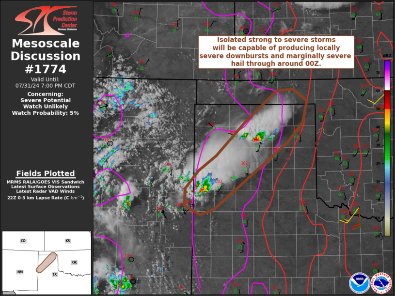
   Areas affected...Portions of the Texas Panhandle into the eastern
   Oklahoma Panhandle

   Concerning...Severe potential...Watch unlikely

   Valid 312232Z - 010000Z

   Probability of Watch Issuance...5 percent

   SUMMARY...Isolated strong to severe storms will be capable of
   producing locally severe downbursts (55-65 mph) and marginally
   severe hail (around 1 inch) through around 00Z.

   DISCUSSION...Isolated thunderstorms are evolving along/immediately
   ahead of a lee trough/dryline feature -- where temperatures have
   warmed into the lower 100s F amid lower 60s dewpoints. Associated
   steep low-level lapse rates and moderate surface-based instability
   will support locally severe downbursts (55-65 mph) and perhaps an
   instance or two of hail around 1 inch. Given around 25 kt of
   deep-layer shear (per AMA VWP and latest mesoanalysis), storm
   longevity should be limited, and the overall severe threat should
   remain fairly isolated.

   ..Weinman/Smith.. 07/31/2024

   ...Please see www.spc.noaa.gov for graphic product...

   ATTN...WFO...LUB...AMA...ABQ...

   LAT...LON   35140292 35440248 36120178 36770096 36800055 36570020
               36110032 35710071 34350253 34240288 34430326 34780325
               35140292
|
|
Top/All Mesoscale Discussions/Forecast Products/Home
|
|


