|
| Mesoscale Discussion 1771 |
|
< Previous MD Next MD >
|

|
   Mesoscale Discussion 1771
   NWS Storm Prediction Center Norman OK
   0444 PM CDT Wed Jul 31 2024

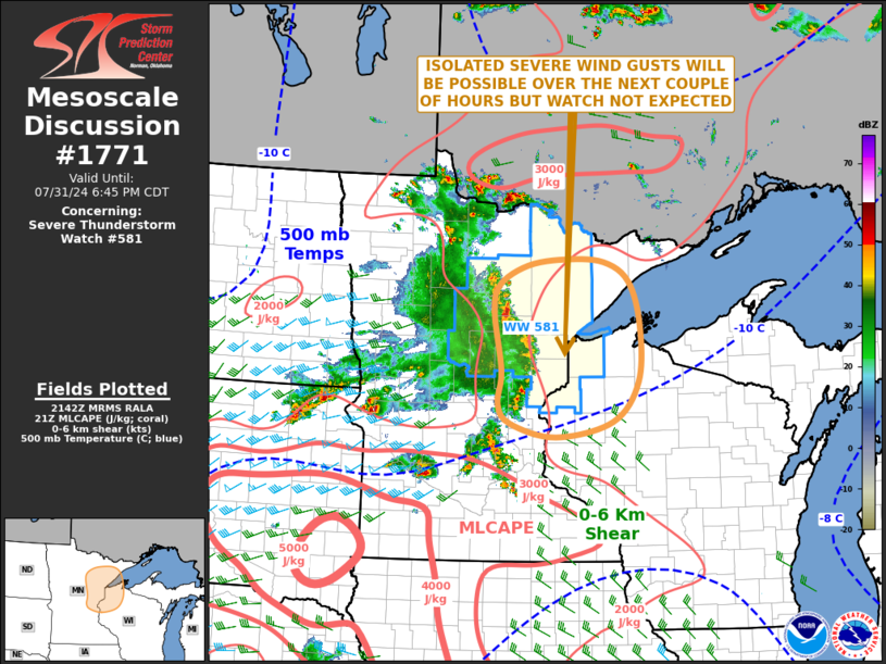
   Areas affected...Eastern Minnesota...Northern Wisconsin

   Concerning...Severe Thunderstorm Watch 581...

   Valid 312144Z - 312345Z

   The severe weather threat for Severe Thunderstorm Watch 581
   continues.

   SUMMARY...An isolated severe threat appears likely to continue for a
   couple more hours across eastern Minnesota. The threat is expected
   to affect parts of northern Wisconsin by early evening. Watch
   issuance is not expected to the east of the current watch.

   DISCUSSION...Latest mosaic radar imagery shows an MCS across eastern
   Minnesota. RAP analysis has MLCAPE in the 2000 to 2500 J/kg range,
   mainly in the area where convection is ongoing. The RAP also has
   moderate deep-layer shear in place over much of this unstable
   airmass, which appears to be due to a mid-level speed max that is
   moving through the eastern Dakotas. A bowing line segment is
   currently ongoing near a surface thermal gradient, to the
   north-northwest of Minneapolis. As this line moves eastward,
   isolated severe gusts will continue to be possible for a couple more
   hours. However, The line will eventually move into much weaker
   instability across northern Wisconsin, where the threat should
   become marginal.

   ..Broyles.. 07/31/2024

   ...Please see www.spc.noaa.gov for graphic product...

   ATTN...WFO...DLH...MPX...

   LAT...LON   47759313 47489371 47099383 46239367 45759373 45479347
               45299254 45509137 46089084 46889079 47529102 47809155
               47839234 47759313
|
|
Top/All Mesoscale Discussions/Forecast Products/Home
|
|


