|
| Mesoscale Discussion 1756 |
|
< Previous MD Next MD >
|

|
   Mesoscale Discussion 1756
   NWS Storm Prediction Center Norman OK
   0809 PM CDT Tue Jul 30 2024

   Areas affected...parts of western and central Kentucky into middle
   Tennessee

   Concerning...Severe potential...Watch possible

   Valid 310109Z - 310315Z

   Probability of Watch Issuance...60 percent

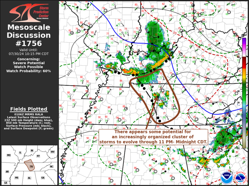
   SUMMARY...Some potential for the evolution of an increasingly
   organized cluster of storms with strong wind gusts exists across
   middle Tennessee late this evening.

   DISCUSSION...Conglomerating convective outflow included notable 2
   hourly surface pressures rises in excess of 4 mb in the 00Z surface
   observation from Owensboro Ky.  There has been some intensification
   of convection on the leading edge of this outflow, which has been
   advancing southeastward around 25-30 kts, in line with the similar
   magnitude northwesterly deep-layer ambient mean flow.

   The most prominent recent cloud top cooling has been focused along
   the southwestern flank of the outflow now approaching the
   Hopkinsville KY vicinity.  This is where stronger
   south-southwesterly system relative low-level inflow of unstable air
   appears focused, and where large-scale forcing for ascent associated
   with low-level convergence and warm advection may be enhanced near
   the intersection of the forward propagating outflow and the stalled
   remnants of prior convective outflow.  It is possible that this
   could still promote the development of a more organized cluster of
   storms accompanied by potentially damaging wind gusts through
   04-05Z, along the stalled boundary extending across the Nashville
   vicinity of middle Tennessee.

   ..Kerr/Hart.. 07/31/2024

   ...Please see www.spc.noaa.gov for graphic product...

   ATTN...WFO...LMK...OHX...HUN...PAH...

   LAT...LON   36978719 37218655 37008634 35578561 35078665 35938734
               36718801 36978719
|
|
Top/All Mesoscale Discussions/Forecast Products/Home
|
|


