|
| Mesoscale Discussion 1753 |
|
< Previous MD Next MD >
|

|
   Mesoscale Discussion 1753
   NWS Storm Prediction Center Norman OK
   0632 PM CDT Tue Jul 30 2024

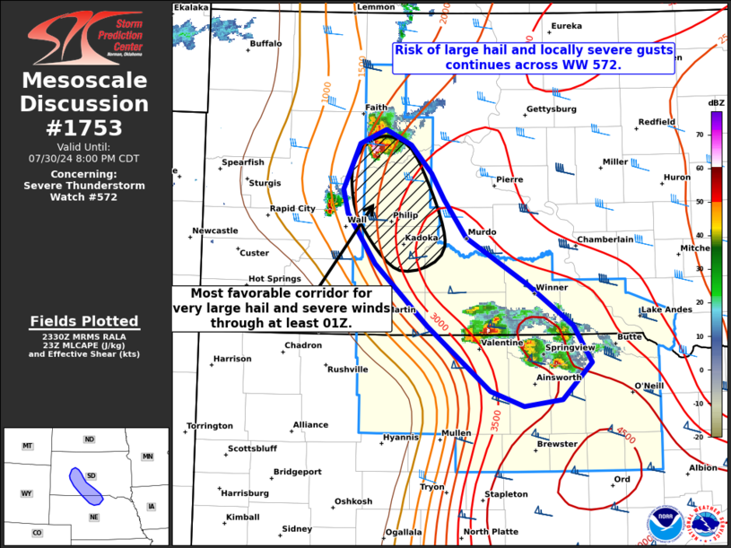
   Areas affected...Portions of western into south-central South Dakota
   and far north-central Nebraska

   Concerning...Severe Thunderstorm Watch 572...

   Valid 302332Z - 310100Z

   The severe weather threat for Severe Thunderstorm Watch 572
   continues.

   SUMMARY...The risk of large hail and locally severe gusts continues
   across Severe Thunderstorm Watch 572.

   DISCUSSION...A few discrete supercells are ongoing from portions of
   west-central SD to north-central NE -- generally focused immediately
   ahead of a north/south-oriented dryline/lee trough. These storms
   have been producing severe hail ranging from 1.25-2.00 inches in
   diameter. Middle/upper 60s to lower 70s dewpoints and steep
   deep-layer lapse rates are contributing to strong surface-based
   instability, which combined with 40-50 kt of effective shear, will
   support a continued increase in updraft intensity during the next
   few hours. Generally weak large-scale and mesoscale ascent will
   likely favor a continued discrete/semi-discrete supercell mode, with
   large to very large hail and locally severe gusts the main concerns.

   Currently, the most intense discrete supercell is turning/deviating
   to the south-southeast across southern Ziebach County, SD. With
   minimal inhibition and the aforementioned shear/instability
   downstream across southwest/south-central SD, this is the most
   favorable corridor for very large hail (up to around 2.5 inches) and
   severe gusts upwards of 75 mph.

   ..Weinman.. 07/30/2024

   ...Please see www.spc.noaa.gov for graphic product...

   ATTN...WFO...FSD...ABR...LBF...UNR...

   LAT...LON   43080119 43650185 44100221 44320226 44750206 44870172
               44740141 44480115 44240099 43890071 43469994 43089936
               42739913 42409950 42349998 42470041 43080119
|
|
Top/All Mesoscale Discussions/Forecast Products/Home
|
|


