|
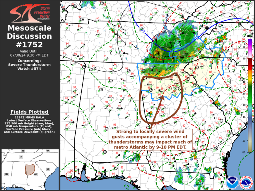
| Mesoscale Discussion 1752 |
|
< Previous MD Next MD >
|

|
   Mesoscale Discussion 1752
   NWS Storm Prediction Center Norman OK
   0627 PM CDT Tue Jul 30 2024

   Areas affected...northern into central Georgia and adjacent portions
   of eastern Alabama

   Concerning...Severe Thunderstorm Watch 574...

   Valid 302327Z - 310130Z

   The severe weather threat for Severe Thunderstorm Watch 574
   continues.

   SUMMARY...A cluster of thunderstorms may overspread much of the
   Greater Atlanta metro area through 9-10 PM EDT, accompanied by
   strong to locally severe wind gusts.

   DISCUSSION...A downburst associated with collapsing convection
   produced wind gusts to 54 kt at Chattanooga Metropolitan airport at
   2216Z, where 2 hourly surface pressure rises up to at least 3.8 mb
   were recorded in the 23Z surface observations.  This is within a
   broader cold pool advancing across the higher terrain of
   southeastern Tennessee, western North Carolina and northeastern
   Georgia.

   Near the leading edge of the outflow associated with the stronger
   downburst, convection has re-intensified some in a small cluster.
   Aided by wind profiles including light westerly low-level flow
   beneath 20-30 kt north-northwesterly mid/upper flow, modest
   southwesterly system relative inflow may continue to support
   strongest renewed convective development south/southwestward across
   much of the Greater Atlanta metro through 01-02Z.  Given the 30 kt
   forward propagation, most peak gusts may remain on the order of
   30-40 kt on the larger-scale, but locally stronger downbursts remain
   possible.

   ..Kerr.. 07/30/2024

   ...Please see www.spc.noaa.gov for graphic product...

   ATTN...WFO...FFC...BMX...

   LAT...LON   34578371 34178347 33548345 33008376 32658443 32628512
               33088544 34318534 34438501 34388460 34448405 34578371
|
|
Top/All Mesoscale Discussions/Forecast Products/Home
|
|


