|
| Mesoscale Discussion 1751 |
|
< Previous MD Next MD >
|
|
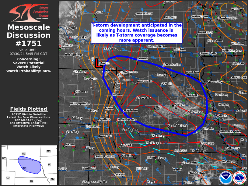
   Mesoscale Discussion 1751
   NWS Storm Prediction Center Norman OK
   0340 PM CDT Tue Jul 30 2024

   Areas affected...Far southern South Dakota into northern and
   northeast Nebraska

   Concerning...Severe potential...Watch likely

   Valid 302040Z - 302245Z

   Probability of Watch Issuance...80 percent

   SUMMARY...Thunderstorm development is anticipated in the next couple
   of hours across north-central Nebraska. Thunderstorms will likely
   intensify, likely into one or more supercells, as they migrate east
   this evening. Watch issuance is likely to address this concern.

   DISCUSSION...Latest GOES visible imagery shows deepening cumulus
   along a weak surface pressure trough and near a subtle surface low.
   A few deeper towers have been noted over the past 20 minutes,
   suggesting that MLCIN is quickly eroding as temperatures climb well
   into the 90s. The remnant outflow from an early-morning MCS lies
   immediately east of the initiation zone with relatively higher
   low-level moisture and east/southeasterly low-level winds. These
   conditions are supporting MLCAPE values upwards of 3000-3500 J/kg
   per recent mesoanalysis estimates. Additionally, the easterly
   low-level flow under 30-40 knot mid-level winds are supporting
   elongated hodographs with effective bulk shear values approaching 50
   knots. As such, this environment should support well-organized
   supercells with an attendant threat for severe winds and very large
   hail (possibly up to 2 inches in diameter). Low-level veering may be
   sufficient for strong low-level mesocyclones, but somewhat high
   dewpoint depressions may limit the overall tornado potential -
   especially with westward extent closer to the initiation zone. Weak
   synoptic-scale forcing for ascent limits confidence in storm
   coverage to some degree, though recent CAM guidance appears to be
   capture observed trends well and suggests one or two supercells will
   become established this evening. Watch issuance will likely be
   needed as this threat materialized.

   ..Moore/Gleason.. 07/30/2024

   ...Please see www.spc.noaa.gov for graphic product...

   ATTN...WFO...FSD...OAX...GID...LBF...UNR...

   LAT...LON   40979933 41280020 41550057 41750074 42480132 42720150
               43160145 43430123 43520080 43500038 43229892 42989799
               42769716 42559669 42029641 41469640 41049661 40779701
               40619744 40979933
|
|
Top/All Mesoscale Discussions/Forecast Products/Home
|
|


 @NWSSPC