|
| Mesoscale Discussion 1749 |
|
< Previous MD Next MD >
|

|
   Mesoscale Discussion 1749
   NWS Storm Prediction Center Norman OK
   0303 PM CDT Tue Jul 30 2024

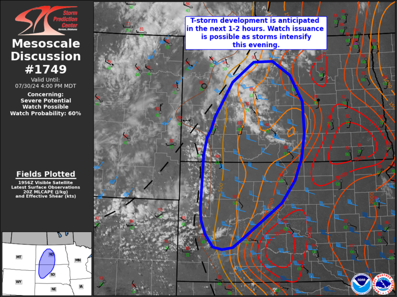
   Areas affected...North and South Dakota

   Concerning...Severe potential...Watch possible

   Valid 302003Z - 302200Z

   Probability of Watch Issuance...60 percent

   SUMMARY...Thunderstorm development is anticipated in the next 1-2
   hours across the western Dakotas. Storms are expected to intensify
   as they migrate east into central North and South Dakota. Watch
   issuance is possible later this afternoon/evening as the severe
   threat becomes more prominent.

   DISCUSSION...Recent GOES visible imagery shows a gradual increase in
   cumulus along a surface trough and within the Black Hills in western
   SD. Mid to upper-level cirrus overspreading the region from the west
   is indicative of gradually increasing synoptic-scale ascent ahead of
   a mid-level shortwave trough over ID/MT. Thunderstorm development
   appears likely in the coming hours as ascent continues to increase
   and continued daytime heating erodes any lingering MLCIN.

   Initial thunderstorms across the western Dakotas will develop within
   a relatively dry/well-mixed environment with LCL heights between 3.0
   to 3.5 km. This environment will favor strong downdraft
   accelerations and rapid cold pool development/expansion with an
   attendant severe wind risk. Convection is expected to intensify as
   it moves east through the evening hours and encounters a reservoir
   of richer low-level moisture (well-sampled by a recent 19 UTC ABR
   sounding). Adequate deep-layer wind shear (around 30-35 knots)
   should support organized convection. Storm coverage remains somewhat
   uncertain given weak forcing for ascent. While the environment may
   support a supercell or two this evening, clustering of initial cells
   is possible and may promote upscale growth and a more robust wind
   threat. Trends will be monitored and watch issuance may be needed
   later this afternoon or evening to address this concern.

   ..Moore/Gleason.. 07/30/2024

   ...Please see www.spc.noaa.gov for graphic product...

   ATTN...WFO...ABR...BIS...UNR...

   LAT...LON   44930049 44030188 43840218 43790254 43850287 44170313
               44510327 44810330 46100323 46540311 46740298 47060283
               47900222 48380147 48400078 48060016 47429973 46649967
               46039979 45490003 44930049
|
|
Top/All Mesoscale Discussions/Forecast Products/Home
|
|


