|
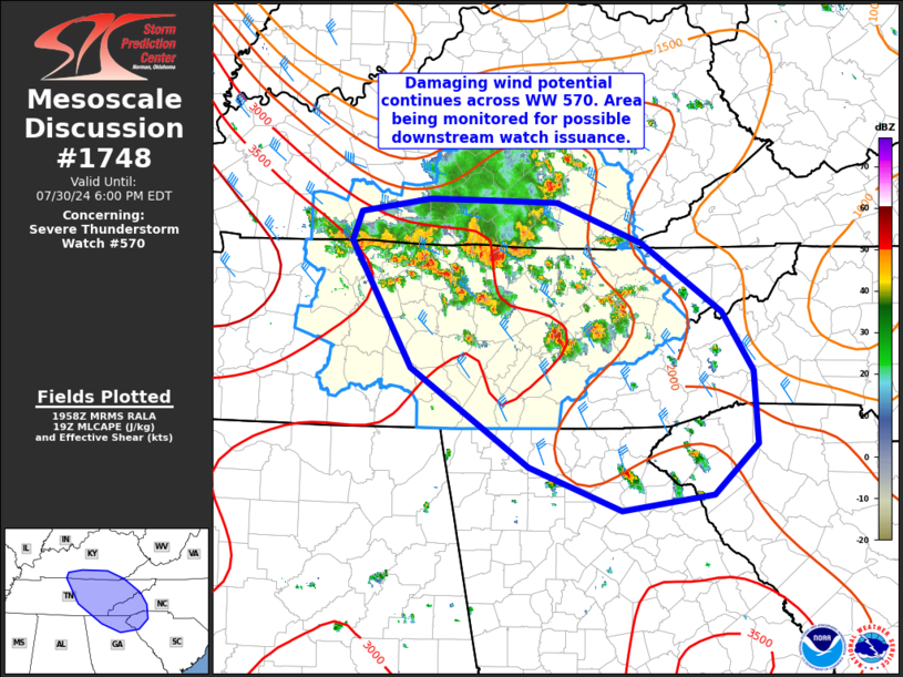
| Mesoscale Discussion 1748 |
|
< Previous MD Next MD >
|

|
   Mesoscale Discussion 1748
   NWS Storm Prediction Center Norman OK
   0301 PM CDT Tue Jul 30 2024

   Areas affected...far southern KY...Middle and eastern TN...western
   NC/SC...and northern GA

   Concerning...Severe Thunderstorm Watch 570...

   Valid 302001Z - 302200Z

   The severe weather threat for Severe Thunderstorm Watch 570
   continues.

   SUMMARY...Damaging wind potential continues across Severe
   Thunderstorm Watch 570. Some severe risk may extend southeast into
   parts of the western Carolinas and northern Georgia. This area is
   being monitored for possible downstream watch issuance.

   DISCUSSION...Ongoing linear cluster near the KY/TN border continues
   to produce sporadic wind damage this afternoon as convection
   develops southeast at around 40-45 kt. Additional more supercellular
   activity over eastern TN also have been sporadically severe. These
   areas of convection are occurring within a moderate to strongly
   unstable airmass within 30-40 kt northwesterly mid/upper flow
   regime. Deep-layer flow weakens with southward extent into SC and
   GA, but an overall favorable environment supporting at least
   sporadic strong to severe storms exists downstream from WW 570.
   Convective trends will continue to be monitored across Middle and
   eastern TN, and some potential for a downstream watch exists over
   parts of western NC/SC and northern GA.

   ..Leitman/Gleason.. 07/30/2024

   ...Please see www.spc.noaa.gov for graphic product...

   ATTN...WFO...GSP...MRX...JKL...FFC...LMK...OHX...

   LAT...LON   36638341 36018253 35488220 34848216 34398264 34248363
               34648464 35518593 36658659 36908650 37028573 37018510
               37008433 36638341
|
|
Top/All Mesoscale Discussions/Forecast Products/Home
|
|


