|
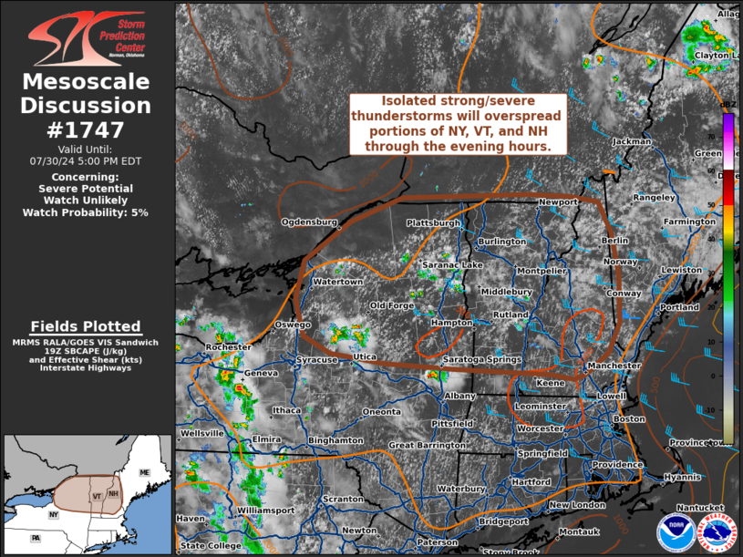
| Mesoscale Discussion 1747 |
|
< Previous MD Next MD >
|

|
   Mesoscale Discussion 1747
   NWS Storm Prediction Center Norman OK
   0206 PM CDT Tue Jul 30 2024

   Areas affected...Northern New York into Vermont and New Hampshire

   Concerning...Severe potential...Watch unlikely

   Valid 301906Z - 302100Z

   Probability of Watch Issuance...5 percent

   SUMMARY...Isolated thunderstorms are beginning to develop across
   portions of north-central New York. Additional storms are
   anticipated through the late afternoon and evening hours and may
   pose a damaging wind and hail threat. Watch issuance is not expected
   given a meager kinematic environment.

   DISCUSSION...Latest regional radar imagery shows isolated
   thunderstorms developing across northern NY within the warm conveyor
   belt ahead of a mid-level shortwave trough. This comes amid gradual
   destabilization with surface temperatures warming into the mid 80s
   with unseasonably high moisture content (dewpoints in the low 70s).
   These warm/moist conditions are promoting SBCAPE values increasing
   from around 1000 J/kg along the international border into the
   2000-2500 J/kg range further south. Buoyancy should continue to
   increase through the early evening within the weak warm advection
   regime, supporting additional thunderstorm development. Latest GOES
   IR imagery and lighting data show periodic, but transient, lightning
   jumps associated with stronger updraft pulses. However, very modest
   mid and upper-level flow (20-25 knots) sampled by regional VWPs is
   limiting hodograph structure and overall deep-layer wind shear
   values. Consequently, convection will likely remain somewhat
   transient with periodic intense updraft pulses. However, somewhat
   steep (7.5-8 C/km) low-level lapse rates may support strong
   downdrafts with the potential for damaging outflow winds (most
   likely between 50-60 mph). Some hail threat may materialize with
   more intense cells given around 25 knots of effective bulk shear,
   but confidence in the development of a robust/organized severe
   threat is low.

   ..Moore/Gleason.. 07/30/2024

   ...Please see www.spc.noaa.gov for graphic product...

   ATTN...WFO...GYX...BTV...ALY...BGM...BUF...

   LAT...LON   43047358 43107470 43207558 43417601 43847616 44307602
               44777528 45067443 45107235 45077166 44997118 44637099
               44147087 43577087 43217107 42957145 42907164 42967201
               43047358
|
|
Top/All Mesoscale Discussions/Forecast Products/Home
|
|


