|
| Mesoscale Discussion 1746 |
|
< Previous MD Next MD >
|

|
   Mesoscale Discussion 1746
   NWS Storm Prediction Center Norman OK
   0156 PM CDT Tue Jul 30 2024

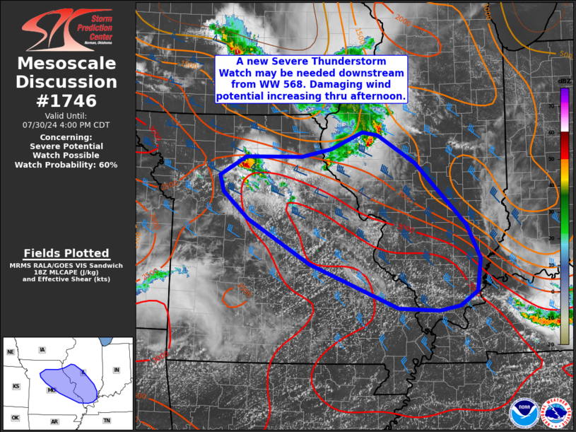
   Areas affected...eastern Missouri into southern Illinois

   Concerning...Severe potential...Watch possible

   Valid 301856Z - 302100Z

   Probability of Watch Issuance...60 percent

   SUMMARY...Severe potential is increasing this afternoon across
   eastern Missouri into southern Illinois. Area is being monitored for
   possible watch issuance downstream from Severe Thunderstorm Watch
   568. Damaging winds may accompany any storms that develop into this
   evening.

   DISCUSSION...While the earlier organized cluster of storms across
   Iowa has largely dissipated, some re-intensification on the southern
   flank has been noted across west-central IL over the past 30 minutes
   or so. Additional convection has developed near the intersection of
   outflow boundaries across northern MO. The downstream airmass across
   east-central MO into southern IL is characterized by temperatures
   near 90 F and dewpoints in the mid/upper 70s F beneath steep
   midlevel lapse rates. This is contributing to a corridor of moderate
   to strong instability, with the gradient of stronger instability
   oriented northwest to southeast from northern MO into southern IL.
   This should support robust thunderstorm updrafts given greater than
   40 kt effective shear magnitudes.

   Uncertainty remains regarding convective coverage and evolution
   given previous rounds of convection. However, the overall
   environment should support severe gust potential with any convection
   that develops. This area is being monitored for watch issuance
   within the next couple of hours.

   ..Leitman/Gleason.. 07/30/2024

   ...Please see www.spc.noaa.gov for graphic product...

   ATTN...WFO...PAH...ILX...LSX...DVN...SGF...EAX...

   LAT...LON   39909307 39919188 40049126 40319060 40279027 39808948
               38788842 38228813 37698819 37448855 37378899 37418985
               38139171 38869301 39319355 39589363 39909307
|
|
Top/All Mesoscale Discussions/Forecast Products/Home
|
|


