|
| Mesoscale Discussion 1745 |
|
< Previous MD Next MD >
|

|
   Mesoscale Discussion 1745
   NWS Storm Prediction Center Norman OK
   1249 PM CDT Tue Jul 30 2024

   Areas affected...far southeast Iowa...northeast Missouri...and
   west-central IL

   Concerning...Severe Thunderstorm Watch 568...

   Valid 301749Z - 301945Z

   The severe weather threat for Severe Thunderstorm Watch 568
   continues.

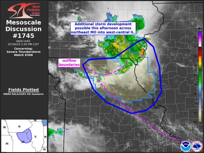
   SUMMARY...Additional storm development is possible across Severe
   Thunderstorm Watch 268 this afternoon.

   DISCUSSION...The earlier bowing cluster of storms across Iowa has
   become disorganized early this afternoon. The strongest cell remains
   on the northern flank crossing into west-central IL. The downstream
   airmass was heavily impacted by early morning convection. Airmass
   recovery is well underway, with MLCAPE around 1000-1500 J/kg, but
   low-level inhibition will likely persist, perhaps limiting severe
   potential with eastward extent.

   Two outflow boundaries are apparent in observed satellite this
   afternoon. A more west to east oriented boundary across northern MO,
   related to the ongoing Iowa cluster. Another boundary is oriented
   northwest to southeast across MO and intersects the northern
   boundary. Deepening cumulus has been noted along both boundaries as
   strong heating and dewpoints increasing into the 70s F has resulted
   in a corridor of moderate to strong instability. Additional
   convection appears likely to develop first near the intersections of
   these outflow boundaries and perhaps re-organize into a
   southeastward-advancing cluster. Given this possibility, Severe
   Thunderstorm Watch 568 continues across northeast MO and
   west-central IL. Depending on convective trends, downstream watch
   issuance may be necessary later this afternoon.

   ..Leitman.. 07/30/2024

   ...Please see www.spc.noaa.gov for graphic product...

   ATTN...WFO...ILX...LSX...DVN...DMX...EAX...

   LAT...LON   40629243 41199134 41289105 40999065 40269038 39579032
               39449029 39009064 38799102 38699165 39069275 39509335
               40359386 40549357 40629243
|
|
Top/All Mesoscale Discussions/Forecast Products/Home
|
|


