|
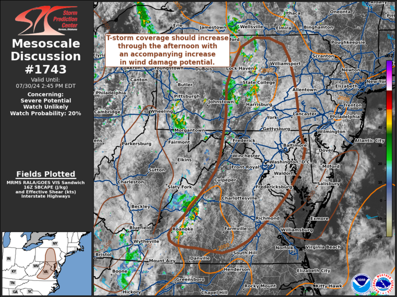
| Mesoscale Discussion 1743 |
|
< Previous MD Next MD >
|

|
   Mesoscale Discussion 1743
   NWS Storm Prediction Center Norman OK
   1139 AM CDT Tue Jul 30 2024

   Areas affected...Pennsylvania...Maryland...and Virginia...including
   Washington D.C.

   Concerning...Severe potential...Watch unlikely

   Valid 301639Z - 301845Z

   Probability of Watch Issuance...20 percent

   SUMMARY...Initially isolated thunderstorms should increase in
   coverage through the afternoon hours with an accompanying increase
   in damaging wind potential. Watch issuance is not anticipated given
   a weak kinematic environment.

   DISCUSSION...GOES imagery and lightning data over the past 30-60
   minutes have shown steadily deepening/intensifying convection along
   a residual outflow boundary and weak surface trough from central PA
   southward into VA. While ongoing convection currently appears to be
   sub-severe based on MRMS hail metrics and regional velocity data,
   temperatures warming into the low 80s should promote SBCAPE values
   up to 2000 J/kg that will likely result in additional thunderstorm
   development as well as some degree of intensification through the
   day with an attendant potential for damaging wind gusts. Given weak
   deep-layer flow over the region, overall convective intensity will
   likely be influenced primarily by low-level heating/destabilization.
   This will be modulated by how quickly residual low-level stratus can
   clear ahead of developing storms. If stronger diurnal heating can be
   achieved (i.e. surface temperatures into the mid/upper 80s) then
   higher SBCAPE (possibly up to 3000 J/kg) and steeper low-level lapse
   rates will likely favor more intense convection with a relatively
   higher damaging wind threat. Regardless, watch issuance is not
   anticipated given the meager deep-layer wind shear and uncertainty
   regarding the thermodynamic environment.

   ..Moore/Gleason.. 07/30/2024

   ...Please see www.spc.noaa.gov for graphic product...

   ATTN...WFO...PHI...BGM...AKQ...CTP...LWX...RNK...

   LAT...LON   36907919 36927952 36977980 37067997 37218002 37357993
               37687957 38087919 38417889 38577878 38787862 39147850
               40067834 40797833 41297813 41727787 41937744 41927699
               41767654 41427634 40847619 40437612 39637603 39267590
               38827602 38167648 37607702 37087765 36907803 36807841
               36847881 36907919
|
|
Top/All Mesoscale Discussions/Forecast Products/Home
|
|


