|
| Mesoscale Discussion 1742 |
|
< Previous MD Next MD >
|

|
   Mesoscale Discussion 1742
   NWS Storm Prediction Center Norman OK
   0909 AM CDT Tue Jul 30 2024

   Areas affected...portions of southern Illinois and southern Indiana
   into north-central Kentucky

   Concerning...Severe Thunderstorm Watch 567...

   Valid 301409Z - 301615Z

   The severe weather threat for Severe Thunderstorm Watch 567
   continues.

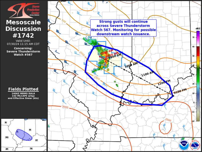
   SUMMARY...Severe thunderstorms posing a damaging wind risk will
   persist across southern Illinois within Severe Thunderstorm Watch
   567. Areas across southern Indiana into adjacent north-central
   Kentucky are being monitored for possible downstream watch issuance.

   DISCUSSION...A small, but well organized bowing cluster of storms
   continues to track east/southeast across south-central Illinois this
   morning. This activity has produced gusts near 50 kt within the past
   hour. Around 30 kt effective shear magnitudes are likely sustaining
   organized activity as convection shifts east/southeast along an
   instability gradient oriented northwest to southeast across the
   lower Ohio Valley vicinity. A very moist downstream airmass is
   evident, with surface dewpoints in the 70s. With continued heating,
   boundary-layer inhibition is expected to quickly erode by midday.
   Damaging gusts may continue downstream of ongoing activity,
   especially if additional convection can develop on the southern
   flank of the ongoing cluster. Visible satellite imagery shows
   deepening cumulus ahead of the southern flank, so this evolution
   appears plausible. A downstream watch may be needed within the next
   hour or so if current trends persist/increase.

   ..Leitman/Gleason.. 07/30/2024

   ...Please see www.spc.noaa.gov for graphic product...

   ATTN...WFO...LMK...IND...PAH...ILX...LSX...

   LAT...LON   39868929 39908894 39748821 39118676 38488582 38088570
               37778619 37818688 37818706 37898751 38188845 38518908
               38968967 39358961 39868929
|
|
Top/All Mesoscale Discussions/Forecast Products/Home
|
|


