|
| Mesoscale Discussion 1741 |
|
< Previous MD Next MD >
|

|
   Mesoscale Discussion 1741
   NWS Storm Prediction Center Norman OK
   0847 AM CDT Tue Jul 30 2024

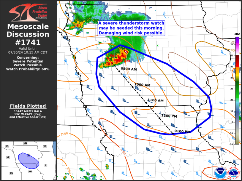
   Areas affected...portions of southern Iowa...northern Missouri...and
   extreme west-central Illinois

   Concerning...Severe potential...Watch possible

   Valid 301347Z - 301515Z

   Probability of Watch Issuance...60 percent

   SUMMARY...Damaging gusts are possible this morning and afternoon as
   a cluster of storms tracks southeast across southern Iowa into
   northern Missouri and extreme west-central Illinois. A watch may be
   needed this morning, though timing is uncertain.

   DISCUSSION...A well organized cluster of storms currently moving
   into central Iowa has produced gusts near 50 kt within the past 30
   minutes or so. This activity may be somewhat elevated in the wake of
   overnight convection. Nevertheless, 35-45 kt effective shear
   magnitudes and MLCAPE around 1000-1500 J/kg will likely maintain
   organization. While outflow from overnight convection has surged
   southward to near I-70 in Missouri, the airmass has shown signs of
   quick recovery, with surface dewpoints in the mid/upper 60s F noted
   in 13z surface obs. Clear skies ahead of the cluster will also allow
   for quick heating through the morning hours. As a result, downstream
   destabilization and erosion of capping is expected.

   The ongoing cluster of storms may continue to gradually intensify
   and pose a risk for damaging gusts into late morning/early afternoon
   as the downstream airmass continue to recover/destabilize. Given the
   effect of overnight convection on the airmass, there is some
   uncertainty in convective evolution and timing of possible watch
   issuance. Nevertheless, it appears possible a severe thunderstorm
   watch could be needed this morning across parts of the discussion
   area.

   ..Leitman/Gleason.. 07/30/2024

   ...Please see www.spc.noaa.gov for graphic product...

   ATTN...WFO...LSX...DVN...DMX...EAX...OAX...

   LAT...LON   42349441 42269405 41809260 41299159 40839101 40509093
               40249100 39839175 39769254 39799287 39929347 40419440
               41129519 41509531 41969529 42349441
|
|
Top/All Mesoscale Discussions/Forecast Products/Home
|
|


