|
| Mesoscale Discussion 1740 |
|
< Previous MD Next MD >
|

|
   Mesoscale Discussion 1740
   NWS Storm Prediction Center Norman OK
   0543 AM CDT Tue Jul 30 2024

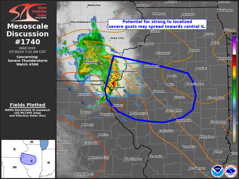
   Areas affected...a part of the Mid-MS Valley to central IL

   Concerning...Severe Thunderstorm Watch 566...

   Valid 301043Z - 301215Z

   The severe weather threat for Severe Thunderstorm Watch 566
   continues.

   SUMMARY...A long-lived short-line segment may continue to produce
   strong to localized severe gusts as it moves east-southeast from the
   Mid-Mississippi Valley towards central Illinois. A downstream severe
   thunderstorm watch issuance is possible pending observational
   trends.

   DISCUSSION...A long-lived short QLCS has steadily progressed
   east-southeast into a portion of the Mid-MS Valley near the IA/IL/MO
   border area. Its forward motion of about 45 kts has been fairly
   consistent, with a bit of recent expansion in length but gradual
   overall warming of IR cloud tops. Intensity in terms of measured
   surface gusts has waned following a relative peak of 64 kts at OTM.
   As such, confidence is low in whether additional strengthening can
   occur given the time of day. But with the presence of 35-kt
   low-level southwesterlies into at least western MO per EAX VWP data,
   and the persistent MLCAPE gradient ahead of the line, some threat
   for strong to localized severe gusts may persist towards central IL.

   ..Grams/Guyer.. 07/30/2024

   ...Please see www.spc.noaa.gov for graphic product...

   ATTN...WFO...LOT...ILX...LSX...DVN...

   LAT...LON   41269138 41089026 40928943 40808888 40618871 40228861
               39868873 39668909 39558971 39579018 39639065 39829122
               40139159 40379167 41269138
|
|
Top/All Mesoscale Discussions/Forecast Products/Home
|
|


