|
| Mesoscale Discussion 1720 |
|
< Previous MD Next MD >
|

|
   Mesoscale Discussion 1720
   NWS Storm Prediction Center Norman OK
   0231 PM CDT Sun Jul 28 2024

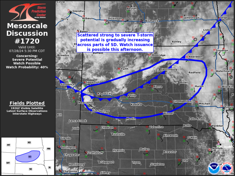
   Areas affected...South Dakota

   Concerning...Severe potential...Watch possible

   Valid 281931Z - 282230Z

   Probability of Watch Issuance...40 percent

   SUMMARY...Thunderstorm coverage is beginning to increase across
   western to northern South Dakota with scattered strong to severe
   storms probable by late afternoon and early evening. Watch issuance
   is possible this afternoon, but timing is uncertain.

   DISCUSSION...Latest GOES imagery shows steady deepening of
   convection along a cold front draped from northeast to western SD as
   well as within the Black Hills. 19 UTC surface observations along
   and south of the front report temperatures in the low 90s -
   considerably warmer than anticipated by recent guidance by this
   time, which implies that boundary-layer mixing (and an accompanying
   erosion of MLCIN) is progressing more rapidly than expected. As
   such, the recent convective trends should continue with additional
   thunderstorm development probable in the coming hours. Although
   moisture quality degrades with westward extent, easterly low-level
   winds on the northern periphery of a surface low are elongating
   hodographs with effective bulk shear values approaching 30-40 knots.
   This will support a window for a supercell or two as initially
   discrete cells develop over the Black Hills and/or along the front
   across western SD. With time, a combination of storm motions largely
   along the front and a 1-2 km deep boundary layer with nearly dry
   adiabatic lapse rates will promote consolidating cold pools and
   upscale growth into one or more clusters as convection propagates to
   the east and into a more moist/buoyant air mass. An organized MCS
   may emerge out of this activity this evening with the potential for
   severe winds, possibly up to 75 mph. Somewhat weak synoptic-scale
   forcing for ascent casts some uncertainty onto overall storm
   coverage, which may favor more isolated cells with limited potential
   for upscale growth and a more localized severe threat. Convective
   trends will be monitored for the need for watch issuance this
   afternoon/evening.

   ..Moore/Gleason.. 07/28/2024

   ...Please see www.spc.noaa.gov for graphic product...

   ATTN...WFO...FSD...ABR...UNR...

   LAT...LON   43550362 43860394 44210404 44410372 44570285 45150051
               45280017 45419983 45459930 45429838 45359777 45279764
               45069753 44829756 44459780 44219801 43939844 43689893
               43509946 43419997 43330052 43270099 43280166 43270224
               43420309 43550362
|
|
Top/All Mesoscale Discussions/Forecast Products/Home
|
|


