|
| Mesoscale Discussion 1721 |
|
< Previous MD Next MD >
|

|
   Mesoscale Discussion 1721
   NWS Storm Prediction Center Norman OK
   0349 PM CDT Sun Jul 28 2024

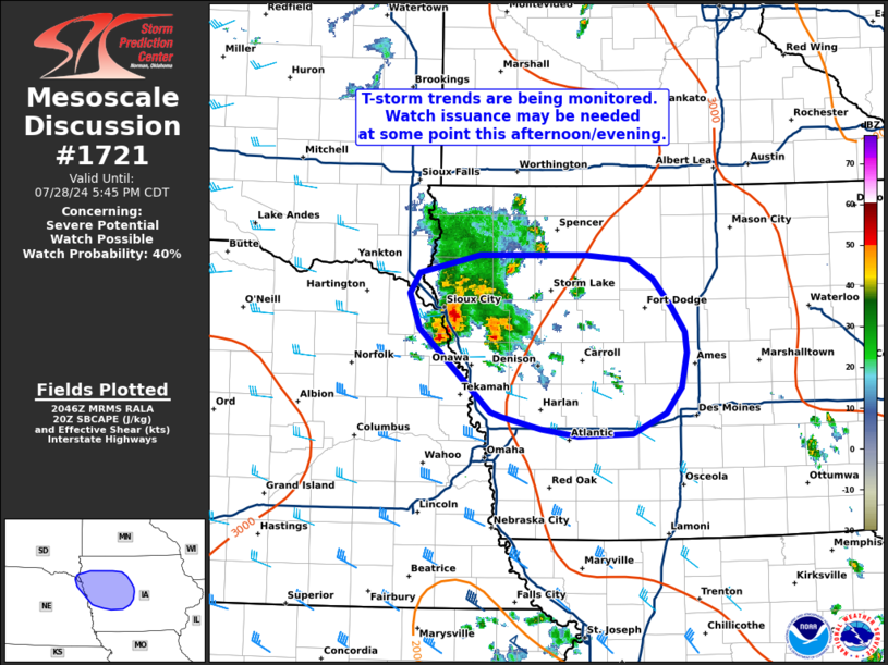
   Areas affected...Northwest to central Iowa

   Concerning...Severe potential...Watch possible

   Valid 282049Z - 282245Z

   Probability of Watch Issuance...40 percent

   SUMMARY...Thunderstorms associated with an MCV across the mid
   Missouri River Valley have shown some signs of intensification over
   the past half hour. Trends will continue to be monitored for the
   need for a watch at some point this afternoon/evening.

   DISCUSSION...Convection has been ongoing for much of the day across
   eastern NE as a residual MCV meanders across the mid-MO River
   Valley. Much of this activity has been driven by a combination of
   ascent associated with the MCV as well as modest warm air advection
   between 850-700 mb. Regional VWPs across eastern KS have shown some
   strengthening of the low-level flow within this warm advection
   regime, suggesting that lift is gradually increasing. Concurrently,
   daytime heating through broken cloud cover has allowed for
   temperatures to climb into the upper 80s across eastern NE into IA
   with a corresponding reduction in surface-based inhibition.
   Consequently, convection has shown some signs of intensification
   over the past 30 minutes, including weak mid-level rotation and
   periodic lightning jumps with the deeper, more intense updrafts.

   Given moderate SBCAPE and sufficient deep-layer shear, organized
   convection appears possible, but storm mode remains uncertain. More
   discrete cells developing on the southern periphery of the MCV
   (where warm advection ascent should be strongest) may pose a large
   hail threat before storm interactions promote gradual upscale growth
   - possibly into an organized cluster later this evening. More recent
   GOES one-minute imagery shows that the more intense updraft pulses
   remain somewhat short lived, possibly indicating that stronger
   forcing for ascent (in the form of an even stronger low-level jet
   this evening) will be required to fully realize the convective
   environment. Trends will continue to be monitored, and watch
   issuance is possible at some point later this afternoon/evening.

   ..Moore/Gleason.. 07/28/2024

   ...Please see www.spc.noaa.gov for graphic product...

   ATTN...WFO...DMX...FSD...OAX...

   LAT...LON   41639587 42319667 42609677 42789667 42929599 42929480
               42889434 42729407 42509387 42299371 42119369 41829376
               41629392 41459429 41439491 41489531 41589575 41639587
|
|
Top/All Mesoscale Discussions/Forecast Products/Home
|
|


