|
| Mesoscale Discussion 1718 |
|
< Previous MD Next MD >
|

|
   Mesoscale Discussion 1718
   NWS Storm Prediction Center Norman OK
   0155 PM CDT Sun Jul 28 2024

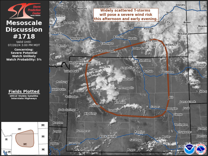
   Areas affected...Northern Wyoming into far southern Montana

   Concerning...Severe potential...Watch unlikely

   Valid 281855Z - 282100Z

   Probability of Watch Issuance...5 percent

   SUMMARY...Widely scattered thunderstorms developing across northern
   Wyoming and far southern Montana will be capable of sporadic severe
   wind gusts this afternoon and early evening. Watch issuance is not
   anticipated given the dispersed nature of the threat.

   DISCUSSION...Isolated and transient thunderstorms have been ongoing
   across parts of northern WY over the past 2-3 hours as
   terrain-driven convection slowly deepens. However, more recent
   visible imagery and lightning data show multiple deep updrafts
   developing within the Absaroka and Wind River ranges. This trend
   will likely persist as temperatures continue to warm into the
   mid/upper 80s in the coming hours and reduce any lingering MLCIN
   across the lower elevations to the east. Buoyancy will remain very
   modest (100-500 J/kg MLCAPE) given the dry environment, but nearly
   dry-adiabatic lapse rates through 2-3 km AGL should facilitate
   efficient downward transfer of stronger mid-level flow as well as
   bolster downdraft acceleration. Additionally, 40 knot winds within
   the CAPE-bearing layer may promote semi-organized cells and/or
   clusters. Severe wind gusts between 60-70 mph appear possible, but
   convective coverage is expected to remain isolated to widely
   scattered and should preclude watch issuance.

   ..Moore/Gleason.. 07/28/2024

   ...Please see www.spc.noaa.gov for graphic product...

   ATTN...WFO...UNR...CYS...BYZ...RIW...

   LAT...LON   42730886 43050943 43570988 44251008 44691001 45030962
               45510732 45750602 45660558 45430537 45170528 44850527
               43240523 42730541 42560563 42470617 42570821 42730886
|
|
Top/All Mesoscale Discussions/Forecast Products/Home
|
|


