|
20250205's Storm Reports (20250205 1200 UTC - 20250206 1159 UTC) (Print Version)
|
< 250204 Reports
250206 Reports >
|
| Note: All Reports Are Considered Preliminary |
|
|
|
|
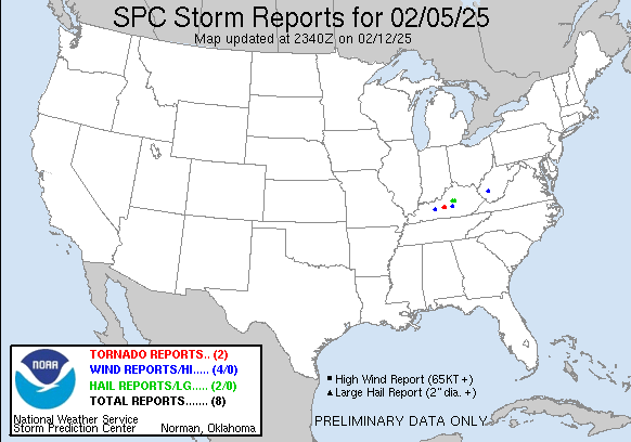
| Tornado Reports (CSV) (Raw Tornado CSV)(?) |
|---|
Time | | Location | County | State | Lat | Lon | Comments |
| 1107 | | 2 E Hammonville | Hart | KY | 3741 | 8576 | An NWS damage survey revealed that a brief EF-1 tornado touched down in NE Hart county. The tornado touched down just southwest of the intersection of US 31E and Levi B (LMK) |
| 1110 | | 4 SE Magnolia | Hart | KY | 3741 | 8571 | The tornado lifted 4 SE of Magnolia along Carl Benningfield Road. (LMK) |
| Hail Reports (CSV) (Raw Hail CSV)(?) |
|---|
Time | Size | Location | County | State | Lat | Lon | Comments |
| 0552 | 175 | Burgin | Mercer | KY | 3775 | 8477 | Multiple reports of ping pong to golfball size hail. Relayed by broadcast media. (LMK) |
| 0557 | 100 | 4 WNW Rose Hill | Mercer | KY | 3777 | 8498 | Quarter size hail reported near Cornishville. (LMK) |
| Wind Reports (CSV) (Raw Wind CSV)(?) |
|---|
Time | Speed | Location | County | State | Lat | Lon | Comments |
| 0920 | UNK | Fosterville | Boone | WV | 3809 | 8160 | Report of several large trees 6-12 inches in diameter and power lines down along Coal River Rd. (RLX) |
| 1054 | UNK | 2 WSW Welchs Creek | Butler | KY | 3733 | 8660 | Trees down on Needmore Road. (LMK) |
| 1056 | UNK | 2 E Hammonville | Hart | KY | 3741 | 8576 | Barn damage and power line damage blown into roadway near intersection of Levi Beams Road and N Jackson Highway near Magnolia. (LMK) |
| 1152 | UNK | 3 SSW Jacktown | Casey | KY | 3741 | 8503 | Carport pole barn rolled over at residence on Button Knob Road. (LMK) |
|
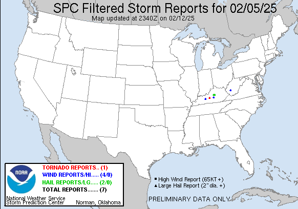
| Filtered Tornado Reports (CSV) (Raw Tornado CSV)(?) |
|---|
Time | | Location | County | State | Lat | Lon | Comments |
| 1107 | | 2 E Hammonville | Hart | KY | 3741 | 8576 | An NWS damage survey revealed that a brief EF-1 tornado touched down in NE Hart county. The tornado touched down just southwest of the intersection of US 31E and Levi B (LMK) |
| Filtered Hail Reports (CSV) (Raw Hail CSV)(?) |
|---|
Time | Size | Location | County | State | Lat | Lon | Comments |
| 0552 | 175 | Burgin | Mercer | KY | 3775 | 8477 | Multiple reports of ping pong to golfball size hail. Relayed by broadcast media. (LMK) |
| 0557 | 100 | 4 WNW Rose Hill | Mercer | KY | 3777 | 8498 | Quarter size hail reported near Cornishville. (LMK) |
| Filtered Wind Reports (CSV) (Raw Wind CSV)(?) |
|---|
Time | Speed | Location | County | State | Lat | Lon | Comments |
| 0920 | UNK | Fosterville | Boone | WV | 3809 | 8160 | Report of several large trees 6-12 inches in diameter and power lines down along Coal River Rd. (RLX) |
| 1054 | UNK | 2 WSW Welchs Creek | Butler | KY | 3733 | 8660 | Trees down on Needmore Road. (LMK) |
| 1056 | UNK | 2 E Hammonville | Hart | KY | 3741 | 8576 | Barn damage and power line damage blown into roadway near intersection of Levi Beams Road and N Jackson Highway near Magnolia. (LMK) |
| 1152 | UNK | 3 SSW Jacktown | Casey | KY | 3741 | 8503 | Carport pole barn rolled over at residence on Button Knob Road. (LMK) |
| The Storm Reports page is organized based on reports received from 1200 UTC to 1159 UTC the next day. For example, storm report page for 20150430 covers reports from 20150430 at 1200 UTC to 20150501 at 1159 UTC. |
| Full report in comma-separated values (CSV) format and in KML format. |
| Full filtered report in comma-separated values (CSV) format and in KML format. |
| KML files are created with time-enabled placemarks compatible with Google Earth Time Slider. |
| Raw full report in comma-separated values (CSV) format. |
| Fields marked UNK are unknown. |
| All Times UTC. |
| Wind Gusts in MPH. |
| Hail Sizes in 1/100 of an Inch (175 = 1.75") |
| LAT/LON in decimal degrees to two decimals, see SPC FAQ for more info. |
| List of Weather Forecast Office 3-letter IDs appear in the report comments section. |
|
|
|
Top/Storm Reports/Home
|
|
|


 @NWSSPC