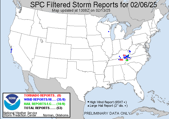
| Tornado Reports (CSV) (Raw Tornado CSV)(?) |
|---|
Time | | Location | County | State | Lat | Lon | Comments |
| 1248 | | Robinet | Rockcastle | KY | 3738 | 8417 | The National Weather Service confirms EF-1 tornado damage in the Robinet Community ... on the eastern side of Rockcastle County ... via storm survey. Time estimated via r (JKL) |
| 1318 | | 1 SE Island City | Owsley | KY | 3735 | 8375 | Corrects previous tornado report from 1 SE Island City. The National Weather Service confirms EF-1 tornado damage near the Island City Community ... on the southwestern (JKL) |
| 0010 | | 6 SSE Gainesboro | Jackson | TN | 3628 | 8561 | The tornado touched down just east of Highway 56 north of Center Grove in Jackson County ... where hundreds of trees were snapped and uprooted as well as some minor roof (OHX) |
| 0020 | | 5 NNW Algood | Putnam | TN | 3627 | 8548 | *** 1 INJ *** Corrects previous tornado report from 5 NNW Algood. This EF1 tornado touched down near Cyphers Drive in northern Putnam County where tree damage was found (OHX) |
| 0041 | | 8 NNE Monterey | Overton | TN | 3625 | 8521 | *** 1 INJ *** This tornado touched down near Coy Phillips Road ... west of Hanging Limb in Overton County. It then tracked east-southeast into Hanging Limb where it snap (OHX) |
| 0053 | | 4 NNW Clarkrange | Fentress | TN | 3623 | 8505 | This tornado touched down northwest of Clarkrange along Baldwin Gulf Road in Fentress County where it caused roofing damage to a residence. The tornado traveled east-so (OHX) |
| 0104 | | 2 SW Deerlodge | Morgan | TN | 3617 | 8479 | *** 2 FATAL ... 2 INJ *** Tornado may have started in southeast Fentress County (pending OHX survey) before tracking into forested areas of Morgan County that were inacc (MRX) |
| 0226 | | 1 WSW Thorn Hill | Grainger | TN | 3635 | 8344 | The tornado began near McAnally Rd and Campground Rd before moving east along Highway 131. There were several barns and outbuildings with roof damage ... and numerous sn (MRX) |
| Hail Reports (CSV) (Raw Hail CSV)(?) |
|---|
Time | Size | Location | County | State | Lat | Lon | Comments |
| 2211 | 175 | Cumberland | Harlan | KY | 3698 | 8299 | NWS Morristown relayed a public report of golf ball sized hail in Cumberland. Time estimated via radar. (JKL) |
| 2220 | 125 | Pennington Gap | Lee | VA | 3677 | 8302 | Corrects previous hail report from 2 S Appalachia. (MRX) |
| 2220 | 125 | 2 S Appalachia | Wise | VA | 3688 | 8279 | (MRX) |
| 2230 | 150 | Dryden | Lee | VA | 3678 | 8294 | (MRX) |
| 2235 | 150 | 2 NNW Wise | Wise | VA | 3701 | 8259 | (MRX) |
| 0102 | 100 | 2 SW Dorton | Pike | KY | 3726 | 8260 | Quarter sized hail reported at Big Branch Hill off of lick fork of Beefhide. Time estimated via radar. (JKL) |
| 0225 | 125 | 1 NW Thorn Hill | Grainger | TN | 3637 | 8344 | Several trees down as well. (MRX) |
| 0240 | 175 | 1 E Kodak | Sevier | TN | 3597 | 8361 | Social media photo of large hail estimated to be at least golf ball sized. Time estimated from radar. (MRX) |
| 0250 | 100 | 2 SE Chestnut Hill | Jefferson | TN | 3592 | 8331 | Time estimated from radar. (MRX) |
| 0300 | 175 | 1 SSW Newport | Cocke | TN | 3595 | 8320 | Social media photo of large hail that caused vehicle damage ... estimated at least golf ball sized and time estimated from radar. (MRX) |
| 0402 | 100 | 5 NNW Hartford | Cocke | TN | 3588 | 8319 | (MRX) |
| Wind Reports (CSV) (Raw Wind CSV)(?) |
|---|
Time | Speed | Location | County | State | Lat | Lon | Comments |
| 1212 | UNK | 4 ENE Monroe | Green | KY | 3725 | 8563 | Tree damage in roadway between Donansburg and New Salem Church along Donansburg New Salem Road. (LMK) |
| 1246 | UNK | 1 WSW Robinet | Rockcastle | KY | 3737 | 8420 | Delayed ... Post-Survey Report. Multiple trees were snapped along Big Cave Road (KY-1004) ... with their trunks blown uniformly to the south. This appears to be related t (JKL) |
| 1248 | UNK | Robinet | Rockcastle | KY | 3738 | 8417 | TOR Possible. Report of a roof off a house on Red Hill Road in Livingston ... KY. Individual contacted the County Emergency Manager about a possible tornado. Time estima (JKL) |
| 1248 | UNK | 2 ESE Hamlin | Lincoln | WV | 3827 | 8207 | Power outage cause by tree damage east of Hamlin. (RLX) |
| 1250 | UNK | 7 S West Hamlin | Lincoln | WV | 3818 | 8218 | Power outage caused by tree damage near WV Route 10. (RLX) |
| 1305 | UNK | 2 SE Madison | Boone | WV | 3804 | 8177 | Power outage caused by tree damage in Uneeda. (RLX) |
| 1318 | UNK | 1 SE Island City | Owsley | KY | 3735 | 8375 | The National Weather Service confirms EF-1 tornado damage near the Island City Community ... on the southwestern side of Owsley County ... via storm survey. Time estimate (JKL) |
| 1325 | UNK | 5 WNW Danville | Boone | WV | 3811 | 8192 | Power outage caused by tree damage. (RLX) |
| 1355 | UNK | 4 NE Mitchell Heights | Logan | WV | 3795 | 8194 | Power outage caused by tree damage along Mill Creek Road and Garrett Fork Road. (RLX) |
| 1437 | UNK | 2 SE Wendover | Leslie | KY | 3711 | 8335 | Corrects previous report from 2 SE Wendover. Tree blown down in the 1800 block of Camp Creek Road. (JKL) |
| 1440 | UNK | 1 SW Marlowe | Letcher | KY | 3713 | 8284 | Abandoned trailer home destroyed by thunderstorm winds. Time estimated as approximately the same time as the Whitesburg ... KY Mesonet reported a 53 mph gust. The mesone (JKL) |
| 2019 | UNK | 2 SE Del Monte Forest | Monterey | CA | 3657 | 12191 | Tree down blocking roadway on Camino del Monte and Serra Avenue. (MTR) |
| 2052 | UNK | 3 SE Del Monte Forest | Monterey | CA | 3656 | 12191 | Tree 1 1/2 feet wide down blocking lanes on Outlook Drive and Greenfield Place. (MTR) |
| 2104 | UNK | 1 N Stockbridge | Calumet | WI | 4407 | 8830 | Report from mPING: 1-inch tree limbs broken; Shingles blown off. (GRB) |
| 2153 | UNK | 1 SE Cupertino | Santa Clara | CA | 3730 | 12203 | Tree branch blocking the slow lane of the onramp from De Anza Boulevard to northbound California Highway 85. (MTR) |
| 2200 | UNK | 2 W Clear Creek Spring | Bell | KY | 3672 | 8376 | Corrects previous tstm wnd dmg report from 1 SSW Wasioto. Tree fell on a power line on road 190. Tree fell at intersection of road 190 and Beckys Branch Road. Time was (JKL) |
| 2237 | UNK | 2 N Scotts Valley | Santa Cruz | CA | 3709 | 12201 | Tree blocking the road at Glenwood Drive and Bean Creek Road. (MTR) |
| 2242 | UNK | 1 SSW Wasioto | Bell | KY | 3674 | 8370 | Tree fell on a power line on road 190. (JKL) |
| 2338 | UNK | 8 N Carthage | Smith | TN | 3637 | 8594 | Debris on Hwy 80 near Pleasant Shade ... road passable. (OHX) |
| 0018 | UNK | 1 E Corbin | Whitley | KY | 3694 | 8410 | Updates previous tstm wnd dmg report from 1 E Corbin. Report of damage along Madison Avenue in Corbin. Large tree was uprooted and fell on a residence and a vehicle. Tr (JKL) |
| 0020 | UNK | Cookeville | Putnam | TN | 3616 | 8551 | Several reports of damage of in north Cookeville ... tree blocking Hwy 293 ... scattered debris ... multiple power flashes. (OHX) |
| 0020 | UNK | 5 NNW Algood | Putnam | TN | 3627 | 8547 | Tree down near house on Cindy Drive in extreme northern Putnam. (OHX) |
| 0020 | UNK | Stinnett | Leslie | KY | 3709 | 8340 | Multiple trees reported down along US-421 between One Stop Gas station and Stinnett Hill Road. (JKL) |
| 0026 | UNK | 1 S Burkesville | Cumberland | KY | 3678 | 8537 | 3 power poles down along highway 90 east of Burkesville ... KY. (LMK) |
| 0035 | UNK | 1 SSW Goldbug | Whitley | KY | 3678 | 8418 | Tree fell over Prewitt Bend Rd ... about 1.5 miles off US-25. Time estimated from radar. (JKL) |
| 0038 | UNK | 8 NE Cookeville | Overton | TN | 3624 | 8540 | Park Rd. in Rickman is blocked. Tree ... power line and transformer are down. (OHX) |
| 0043 | UNK | 3 NW Bledsoe | Leslie | KY | 3696 | 8340 | Updates previous tstm wnd dmg report from 3 NW Bledsoe. Leslie County 911 Center previously reported many tree limbs downed along 2058 before the intersection with 421. (JKL) |
| 0044 | UNK | 12 ENE Cookeville | Overton | TN | 3622 | 8531 | Multiple power flashes in the Crawford community. (OHX) |
| 0044 | UNK | 8 NW Clarkrange | Overton | TN | 3627 | 8512 | Multiple power flashes. (OHX) |
| 0118 | UNK | Deerlodge | Morgan | TN | 3620 | 8476 | Several homes damaged and trees down. Reports of fatalities but number unknown. Possible tornado. (MRX) |
| 0125 | UNK | 1 E Deerlodge | Morgan | TN | 3620 | 8475 | Several homes damaged and trees down. Possible tornado. (MRX) |
| 0127 | UNK | 2 WSW Incline | Harlan | KY | 3691 | 8331 | Delayed Report. NWS Storm Survey team discovered many tree branches snapped along KY-221 in between 421 and 2009 in NW Harlan County. Damage was unidirectional. Time es (JKL) |
| 0140 | UNK | 2 SSE Pound | Wise | VA | 3710 | 8260 | Several trees down. (MRX) |
| 0141 | UNK | Clover Fork | Harlan | KY | 3688 | 8293 | A tree was reportedly blown down onto KY-38 near MM 28. Time estimated. (JKL) |
| 0147 | UNK | Speedwell | Claiborne | TN | 3646 | 8387 | A few trees down. (MRX) |
| 0210 | UNK | Jonesville | Lee | VA | 3669 | 8311 | Several trees down. (MRX) |
| 0235 | UNK | 1 NNW Mount Carmel | Hawkins | TN | 3658 | 8267 | Several trees down. (MRX) |
| 0250 | UNK | 4 NNW Kingsport | Sullivan | TN | 3658 | 8258 | Social media photo of a tree that fell on a car in northern Kingsport. Time is estimated from radar. (MRX) |
| 0255 | UNK | 2 NNE Mohawk | Greene | TN | 3623 | 8304 | Several trees down. (MRX) |
| 0329 | UNK | 1 SSW Bluff City | Sullivan | TN | 3645 | 8228 | A few trees down. (MRX) |


 @NWSSPC