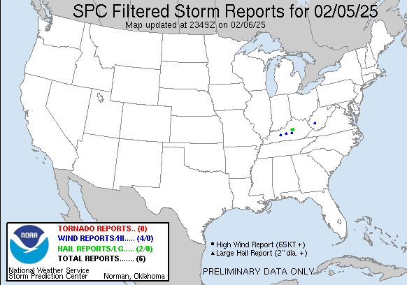
250205's Storm Reports (20250205 1200 UTC - 20250206 1159 UTC)
|
< 250204 Reports
250206 Reports >
|

| Tornado Reports (CSV) (Raw Tornado CSV)(?) |
|---|
| No reports received |
| Hail Reports (CSV) (Raw Hail CSV)(?) |
|---|
Time | Size | Location | County | State | Lat | Lon | Comments |
| 0552 | 175 | Burgin | Mercer | KY | 3775 | 8477 | Multiple reports of ping pong to golfball size hail. Relayed by broadcast media. (LMK) |
| 0557 | 100 | 4 WNW Rose Hill | Mercer | KY | 3777 | 8498 | Quarter size hail reported near Cornishville. (LMK) |
| Wind Reports (CSV) (Raw Wind CSV)(?) |
|---|
Time | Speed | Location | County | State | Lat | Lon | Comments |
| 0920 | UNK | Fosterville | Boone | WV | 3809 | 8160 | Report of several large trees 6-12 inches in diameter and power lines down along Coal River Rd. (RLX) |
| 1054 | UNK | 2 WSW Welchs Creek | Butler | KY | 3733 | 8660 | Trees down on Needmore Road. (LMK) |
| 1056 | UNK | 2 E Hammonville | Hart | KY | 3741 | 8576 | Barn damage and power line damage blown into roadway near intersection of Levi Beams Road and N Jackson Highway near Magnolia. (LMK) |
| 1152 | UNK | 3 SSW Jacktown | Casey | KY | 3741 | 8503 | Carport pole barn rolled over at residence on Button Knob Road. (LMK) |
|
| Filtered Tornado Reports (CSV) (Raw Tornado CSV)(?) |
|---|
| No reports received |
| Filtered Hail Reports (CSV) (Raw Hail CSV)(?) |
|---|
Time | Size | Location | County | State | Lat | Lon | Comments |
| 0552 | 175 | Burgin | Mercer | KY | 3775 | 8477 | Multiple reports of ping pong to golfball size hail. Relayed by broadcast media. (LMK) |
| 0557 | 100 | 4 WNW Rose Hill | Mercer | KY | 3777 | 8498 | Quarter size hail reported near Cornishville. (LMK) |
| Filtered Wind Reports (CSV) (Raw Wind CSV)(?) |
|---|
Time | Speed | Location | County | State | Lat | Lon | Comments |
| 0920 | UNK | Fosterville | Boone | WV | 3809 | 8160 | Report of several large trees 6-12 inches in diameter and power lines down along Coal River Rd. (RLX) |
| 1054 | UNK | 2 WSW Welchs Creek | Butler | KY | 3733 | 8660 | Trees down on Needmore Road. (LMK) |
| 1056 | UNK | 2 E Hammonville | Hart | KY | 3741 | 8576 | Barn damage and power line damage blown into roadway near intersection of Levi Beams Road and N Jackson Highway near Magnolia. (LMK) |
| 1152 | UNK | 3 SSW Jacktown | Casey | KY | 3741 | 8503 | Carport pole barn rolled over at residence on Button Knob Road. (LMK) |
|
| Full report in comma-separated values (CSV) format and in KML format. |
| Full filtered report in comma-separated values (CSV) format and in KML format. |
| Raw full report in comma-separated values (CSV) format |
| Fields marked UNK are unknown |
| All Times UTC |
| Wind Gusts in MPH |
| Hail Sizes in 1/100 of an Inch (175 = 1.75\") |
| LAT/LON in decimal degrees to two decimals, see SPC FAQ for more info |
| List of Weather Forecast Office 3-letter IDs appear in the report comments section |
|
|
|
Top/Storm Reports/Home
|