 Note:
The expiration time in the watch graphic is amended if the watch is
replaced, cancelled or extended.
Note:
Note:
The expiration time in the watch graphic is amended if the watch is
replaced, cancelled or extended.
Note: Click for
Watch Status Reports.
SEL6
URGENT - IMMEDIATE BROADCAST REQUESTED
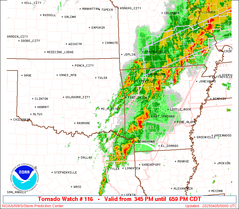
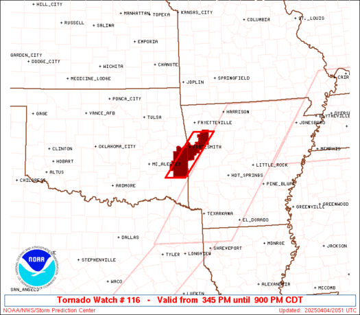
Tornado Watch Number 116
NWS Storm Prediction Center Norman OK
345 PM CDT Fri Apr 4 2025
The NWS Storm Prediction Center has issued a
* Tornado Watch for portions of
Exteme west central Arkansas
Extreme east central Oklahoma
* Effective this Friday afternoon and evening from 345 PM until
900 PM CDT.
* Primary threats include...
A few tornadoes and a couple intense tornadoes possible
Scattered large hail and isolated very large hail events to 2
inches in diameter possible
Scattered damaging wind gusts to 70 mph possible
SUMMARY...Supercells along a stalled front will move into the area
of east central Oklahoma and west central Arkansas (close to Fort
Smith) just to the west of the earlier tornado watch to the east in
Arkansas. A couple of tornadoes, including the chance for a strong
tornado, large hail and wind damage will all be possible this
afternoon/evening before the storms shift farther east into
Arkansas.
The tornado watch area is approximately along and 20 statute miles
east and west of a line from 40 miles northeast of Fort Smith AR to
40 miles south southwest of Poteau OK. For a complete depiction of
the watch see the associated watch outline update (WOUS64 KWNS
WOU6).
PRECAUTIONARY/PREPAREDNESS ACTIONS...
REMEMBER...A Tornado Watch means conditions are favorable for
tornadoes and severe thunderstorms in and close to the watch
area. Persons in these areas should be on the lookout for
threatening weather conditions and listen for later statements
and possible warnings.
&&
OTHER WATCH INFORMATION...CONTINUE...WW 113...WW 114...WW 115...
AVIATION...Tornadoes and a few severe thunderstorms with hail
surface and aloft to 2 inches. Extreme turbulence and surface wind
gusts to 60 knots. A few cumulonimbi with maximum tops to 550. Mean
storm motion vector 22040.
...Thompson

SEL6
URGENT - IMMEDIATE BROADCAST REQUESTED
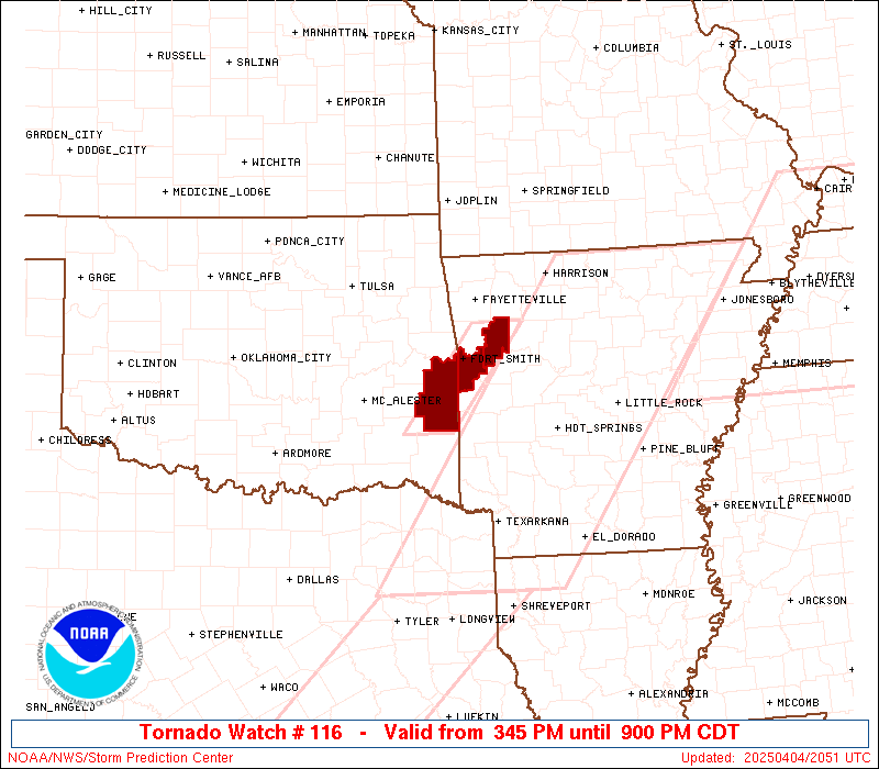
Tornado Watch Number 116
NWS Storm Prediction Center Norman OK
345 PM CDT Fri Apr 4 2025
The NWS Storm Prediction Center has issued a
* Tornado Watch for portions of
Exteme west central Arkansas
Extreme east central Oklahoma
* Effective this Friday afternoon and evening from 345 PM until
900 PM CDT.
* Primary threats include...
A few tornadoes and a couple intense tornadoes possible
Scattered large hail and isolated very large hail events to 2
inches in diameter possible
Scattered damaging wind gusts to 70 mph possible
SUMMARY...Supercells along a stalled front will move into the area
of east central Oklahoma and west central Arkansas (close to Fort
Smith) just to the west of the earlier tornado watch to the east in
Arkansas. A couple of tornadoes, including the chance for a strong
tornado, large hail and wind damage will all be possible this
afternoon/evening before the storms shift farther east into
Arkansas.
The tornado watch area is approximately along and 20 statute miles
east and west of a line from 40 miles northeast of Fort Smith AR to
40 miles south southwest of Poteau OK. For a complete depiction of
the watch see the associated watch outline update (WOUS64 KWNS
WOU6).
PRECAUTIONARY/PREPAREDNESS ACTIONS...
REMEMBER...A Tornado Watch means conditions are favorable for
tornadoes and severe thunderstorms in and close to the watch
area. Persons in these areas should be on the lookout for
threatening weather conditions and listen for later statements
and possible warnings.
&&
OTHER WATCH INFORMATION...CONTINUE...WW 113...WW 114...WW 115...
AVIATION...Tornadoes and a few severe thunderstorms with hail
surface and aloft to 2 inches. Extreme turbulence and surface wind
gusts to 60 knots. A few cumulonimbi with maximum tops to 550. Mean
storm motion vector 22040.
...Thompson
 Note:
The Aviation Watch (SAW) product is an approximation to the watch area.
The actual watch is depicted by the shaded areas.
Note:
The Aviation Watch (SAW) product is an approximation to the watch area.
The actual watch is depicted by the shaded areas.
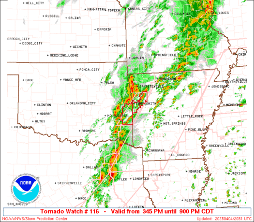
   SAW6
   WW 116 TORNADO AR OK 042045Z - 050200Z
   AXIS..20 STATUTE MILES EAST AND WEST OF LINE..
   40NE FSM/FORT SMITH AR/ - 40SSW RKR/POTEAU OK/
   ..AVIATION COORDS.. 15NM E/W /29NE FSM - 49ESE MLC/
   HAIL SURFACE AND ALOFT..2 INCHES. WIND GUSTS..60 KNOTS.
   MAX TOPS TO 550. MEAN STORM MOTION VECTOR 22040.

   LAT...LON 35749351 34489454 34489524 35749422

   THIS IS AN APPROXIMATION TO THE WATCH AREA.  FOR A
   COMPLETE DEPICTION OF THE WATCH SEE WOUS64 KWNS
   FOR WOU6.
Watch 116 Status Report Messages:
STATUS REPORT #3 ON WW 116

VALID 042305Z - 050040Z

SEVERE WEATHER THREAT CONTINUES RIGHT OF A LINE FROM 30 N DEQ TO
10 N FYV.

..LYONS..04/04/25

ATTN...WFO...TSA...

&&

STATUS REPORT FOR WT 116

SEVERE WEATHER THREAT CONTINUES FOR THE FOLLOWING AREAS

ARC047-131-050040-

AR
.    ARKANSAS COUNTIES INCLUDED ARE

FRANKLIN	     SEBASTIAN
$$


THE WATCH STATUS MESSAGE IS FOR GUIDANCE PURPOSES ONLY.  PLEASE
REFER TO WATCH COUNTY NOTIFICATION STATEMENTS FOR OFFICIAL
INFORMATION ON COUNTIES...INDEPENDENT CITIES AND MARINE ZONES
CLEARED FROM SEVERE THUNDERSTORM AND TORNADO WATCHES.
$$

STATUS REPORT #2 ON WW 116

VALID 042150Z - 042240Z

THE SEVERE WEATHER THREAT CONTINUES ACROSS THE ENTIRE WATCH AREA.

..LYONS..04/04/25

ATTN...WFO...TSA...

&&

STATUS REPORT FOR WT 116

SEVERE WEATHER THREAT CONTINUES FOR THE FOLLOWING AREAS

ARC047-131-042240-

AR
.    ARKANSAS COUNTIES INCLUDED ARE

FRANKLIN	     SEBASTIAN
$$


OKC079-042240-

OK
.    OKLAHOMA COUNTIES INCLUDED ARE

LE FLORE
$$


THE WATCH STATUS MESSAGE IS FOR GUIDANCE PURPOSES ONLY.  PLEASE
REFER TO WATCH COUNTY NOTIFICATION STATEMENTS FOR OFFICIAL
INFORMATION ON COUNTIES...INDEPENDENT CITIES AND MARINE ZONES
CLEARED FROM SEVERE THUNDERSTORM AND TORNADO WATCHES.
$$

STATUS REPORT #1 ON WW 116

VALID 042055Z - 042140Z

THE SEVERE WEATHER THREAT CONTINUES ACROSS THE ENTIRE WATCH AREA.

..LYONS..04/04/25

ATTN...WFO...TSA...

&&

STATUS REPORT FOR WT 116

SEVERE WEATHER THREAT CONTINUES FOR THE FOLLOWING AREAS

ARC047-131-042140-

AR
.    ARKANSAS COUNTIES INCLUDED ARE

FRANKLIN	     SEBASTIAN
$$


OKC079-042140-

OK
.    OKLAHOMA COUNTIES INCLUDED ARE

LE FLORE
$$


THE WATCH STATUS MESSAGE IS FOR GUIDANCE PURPOSES ONLY.  PLEASE
REFER TO WATCH COUNTY NOTIFICATION STATEMENTS FOR OFFICIAL
INFORMATION ON COUNTIES...INDEPENDENT CITIES AND MARINE ZONES
CLEARED FROM SEVERE THUNDERSTORM AND TORNADO WATCHES.
$$
Note:
Click for Complete Product Text.
Tornadoes
Probability of 2 or more tornadoes
|
Mod (50%)
|
Probability of 1 or more strong (EF2-EF5) tornadoes
|
Mod (30%)
|
Wind
Probability of 10 or more severe wind events
|
Mod (40%)
|
Probability of 1 or more wind events > 65 knots
|
Low (20%)
|
Hail
Probability of 10 or more severe hail events
|
Mod (50%)
|
Probability of 1 or more hailstones > 2 inches
|
Mod (30%)
|
Combined Severe Hail/Wind
Probability of 6 or more combined severe hail/wind events
|
High (70%)
|
For each watch, probabilities for particular events inside the watch
(listed above in each table) are determined by the issuing forecaster.
The "Low" category contains probability values ranging from less than 2%
to 20% (EF2-EF5 tornadoes), less than 5% to 20% (all other probabilities),
"Moderate" from 30% to 60%, and "High" from 70% to greater than 95%.
High values are bolded and lighter in color to provide awareness of
an increased threat for a particular event.


 @NWSSPC