 Note:
The expiration time in the watch graphic is amended if the watch is
replaced, cancelled or extended.
Note:
Note:
The expiration time in the watch graphic is amended if the watch is
replaced, cancelled or extended.
Note: Click for
Watch Status Reports.
SEL2
URGENT - IMMEDIATE BROADCAST REQUESTED
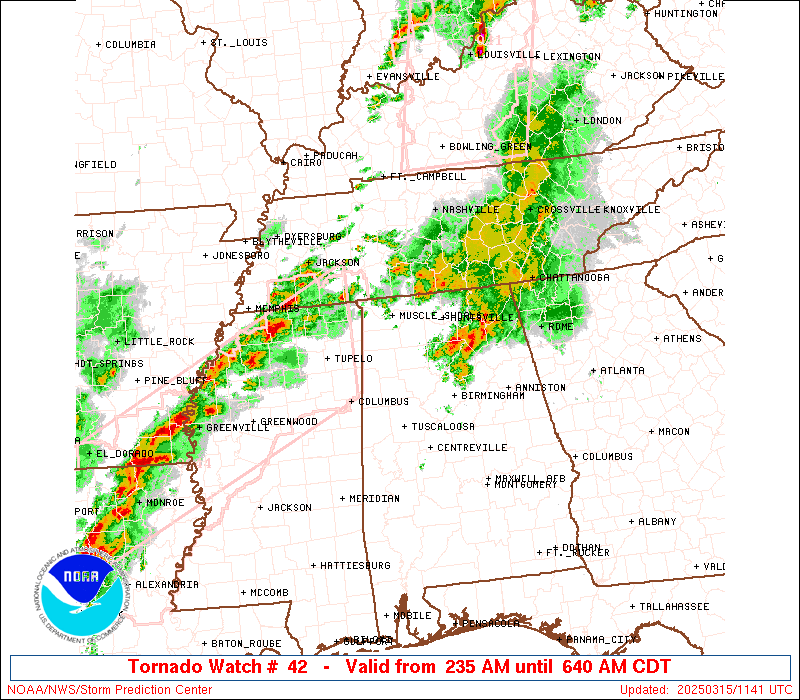
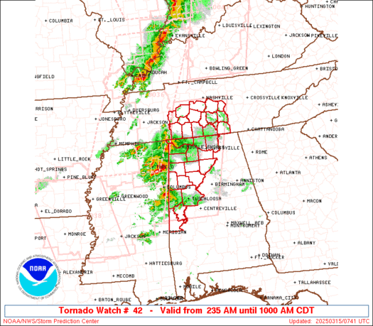
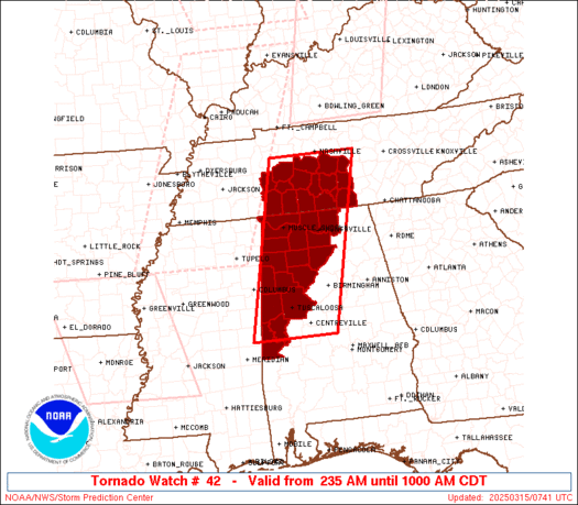
Tornado Watch Number 42
NWS Storm Prediction Center Norman OK
235 AM CDT Sat Mar 15 2025
The NWS Storm Prediction Center has issued a
* Tornado Watch for portions of
Western and Northern Alabama
Southern Middle Tennessee
* Effective this Saturday morning from 235 AM until 1000 AM CDT.
* Primary threats include...
A couple tornadoes possible
Scattered damaging wind gusts to 70 mph possible
Isolated large hail events to 1 inch in diameter possible
SUMMARY...A cluster of severe thunderstorms will continue northeast
on the eastern periphery of a moist and unstable warm sector. A few
supercells will be potentially capable of a tornado risk, as well as
a risk for damaging gusts and perhaps some hail through the early
morning.
The tornado watch area is approximately along and 55 statute miles
east and west of a line from 100 miles north of Huntsville AL to 40
miles south of Tuscaloosa AL. For a complete depiction of the watch
see the associated watch outline update (WOUS64 KWNS WOU2).
PRECAUTIONARY/PREPAREDNESS ACTIONS...
REMEMBER...A Tornado Watch means conditions are favorable for
tornadoes and severe thunderstorms in and close to the watch
area. Persons in these areas should be on the lookout for
threatening weather conditions and listen for later statements
and possible warnings.
&&
OTHER WATCH INFORMATION...CONTINUE...WW 36...WW 37...WW 38...WW
40...WW 41...
AVIATION...Tornadoes and a few severe thunderstorms with hail
surface and aloft to 1 inch. Extreme turbulence and surface wind
gusts to 60 knots. A few cumulonimbi with maximum tops to 450. Mean
storm motion vector 24040.
...Smith

   SEL2

   URGENT - IMMEDIATE BROADCAST REQUESTED
   Tornado Watch Number 42
   NWS Storm Prediction Center Norman OK
   235 AM CDT Sat Mar 15 2025

   The NWS Storm Prediction Center has issued a

   * Tornado Watch for portions of
     Western and Northern Alabama
     Southern Middle Tennessee

   * Effective this Saturday morning from 235 AM until 1000 AM CDT.

   * Primary threats include...
     A couple tornadoes possible
     Scattered damaging wind gusts to 70 mph possible
     Isolated large hail events to 1 inch in diameter possible

   SUMMARY...A cluster of severe thunderstorms will continue northeast
   on the eastern periphery of a moist and unstable warm sector.  A few
   supercells will be potentially capable of a tornado risk, as well as
   a risk for damaging gusts and perhaps some hail through the early
   morning.

   The tornado watch area is approximately along and 55 statute miles
   east and west of a line from 100 miles north of Huntsville AL to 40
   miles south of Tuscaloosa AL. For a complete depiction of the watch
   see the associated watch outline update (WOUS64 KWNS WOU2).

   PRECAUTIONARY/PREPAREDNESS ACTIONS...

   REMEMBER...A Tornado Watch means conditions are favorable for
   tornadoes and severe thunderstorms in and close to the watch
   area. Persons in these areas should be on the lookout for
   threatening weather conditions and listen for later statements
   and possible warnings.

   &&

   OTHER WATCH INFORMATION...CONTINUE...WW 36...WW 37...WW 38...WW
   40...WW 41...

   AVIATION...Tornadoes and a few severe thunderstorms with hail
   surface and aloft to 1 inch. Extreme turbulence and surface wind
   gusts to 60 knots. A few cumulonimbi with maximum tops to 450. Mean
   storm motion vector 24040.

   ...Smith
 Note:
The Aviation Watch (SAW) product is an approximation to the watch area.
The actual watch is depicted by the shaded areas.
Note:
The Aviation Watch (SAW) product is an approximation to the watch area.
The actual watch is depicted by the shaded areas.
SAW2
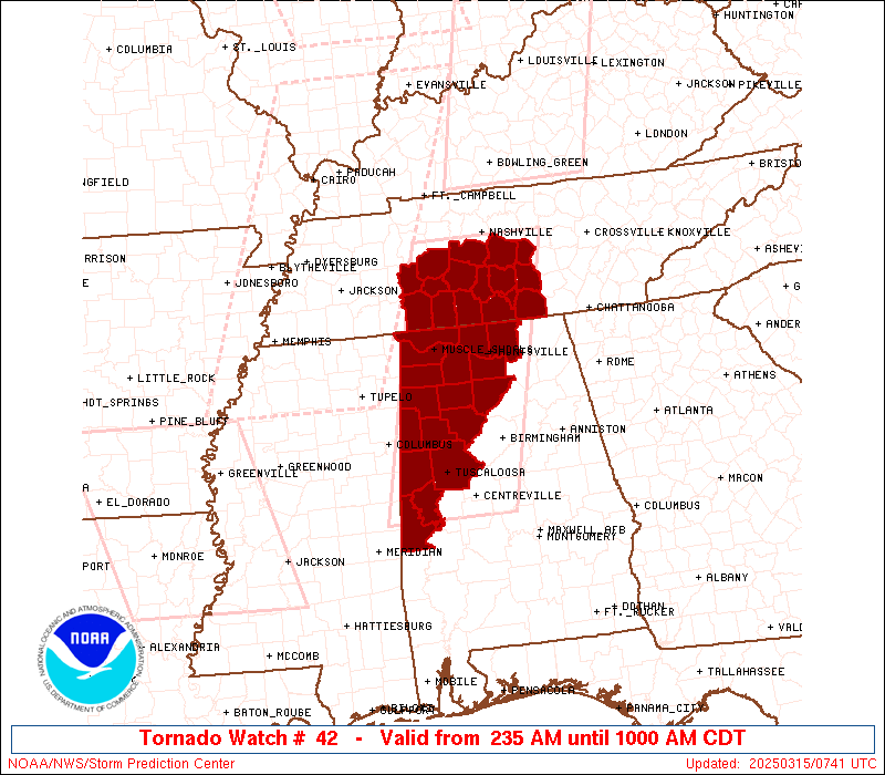
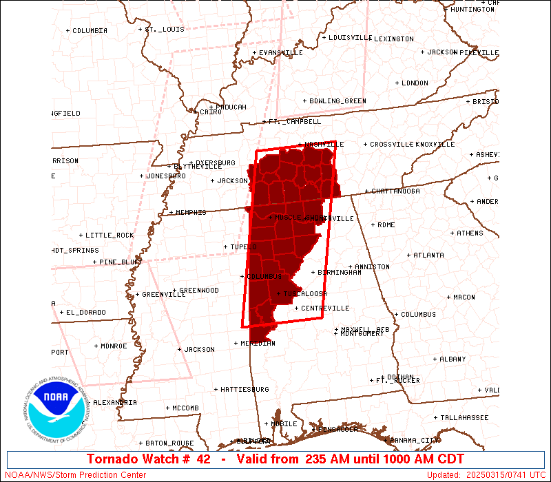
WW 42 TORNADO AL TN 150735Z - 151500Z
AXIS..55 STATUTE MILES EAST AND WEST OF LINE..
100N HSV/HUNTSVILLE AL/ - 40S TCL/TUSCALOOSA AL/
..AVIATION COORDS.. 50NM E/W /5WSW BNA - 62ENE MEI/
HAIL SURFACE AND ALOFT..1 INCH. WIND GUSTS..60 KNOTS.
MAX TOPS TO 450. MEAN STORM MOTION VECTOR 24040.
LAT...LON 36098579 32648667 32648857 36098777
THIS IS AN APPROXIMATION TO THE WATCH AREA. FOR A
COMPLETE DEPICTION OF THE WATCH SEE WOUS64 KWNS
FOR WOU2.
Watch 42 Status Report Messages:
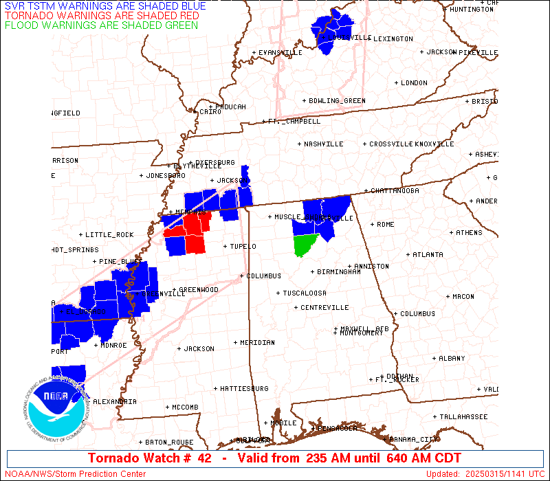
STATUS REPORT #1 ON WW 42

VALID 151135Z - 151500Z

SEVERE WEATHER THREAT CONTINUES RIGHT OF A LINE FROM 30 SE BHM TO
35 NNW BHM TO 25 NE HSV TO 35 WNW CHA.

WW 42 WILL BE ALLOWED TO EXPIRE AT 151500Z.

..SQUITIERI..03/15/25

ATTN...WFO...HUN...BMX...OHX...

&&

STATUS REPORT FOR WT 42

SEVERE WEATHER THREAT CONTINUES FOR THE FOLLOWING AREAS

ALC043-089-151500-

AL
.    ALABAMA COUNTIES INCLUDED ARE

CULLMAN 	     MADISON
$$


THE WATCH STATUS MESSAGE IS FOR GUIDANCE PURPOSES ONLY.  PLEASE
REFER TO WATCH COUNTY NOTIFICATION STATEMENTS FOR OFFICIAL
INFORMATION ON COUNTIES...INDEPENDENT CITIES AND MARINE ZONES
CLEARED FROM SEVERE THUNDERSTORM AND TORNADO WATCHES.
$$
Note:
Click for Complete Product Text.
Tornadoes
Probability of 2 or more tornadoes
|
Mod (40%)
|
Probability of 1 or more strong (EF2-EF5) tornadoes
|
Low (20%)
|
Wind
Probability of 10 or more severe wind events
|
Mod (40%)
|
Probability of 1 or more wind events > 65 knots
|
Low (10%)
|
Hail
Probability of 10 or more severe hail events
|
Mod (30%)
|
Probability of 1 or more hailstones > 2 inches
|
Low (10%)
|
Combined Severe Hail/Wind
Probability of 6 or more combined severe hail/wind events
|
High (70%)
|
For each watch, probabilities for particular events inside the watch
(listed above in each table) are determined by the issuing forecaster.
The "Low" category contains probability values ranging from less than 2%
to 20% (EF2-EF5 tornadoes), less than 5% to 20% (all other probabilities),
"Moderate" from 30% to 60%, and "High" from 70% to greater than 95%.
High values are bolded and lighter in color to provide awareness of
an increased threat for a particular event.


 @NWSSPC