Note:
The expiration time in the watch graphic is amended if the watch is
replaced, cancelled or extended.
Note:
Note:
The expiration time in the watch graphic is amended if the watch is
replaced, cancelled or extended.
Note: Click for
Watch Status Reports.
SEL1
URGENT - IMMEDIATE BROADCAST REQUESTED
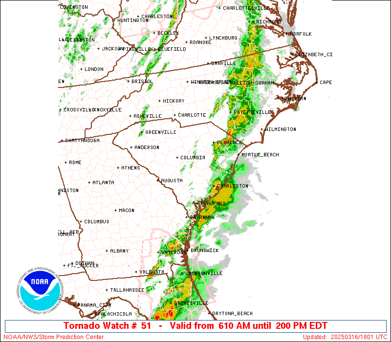
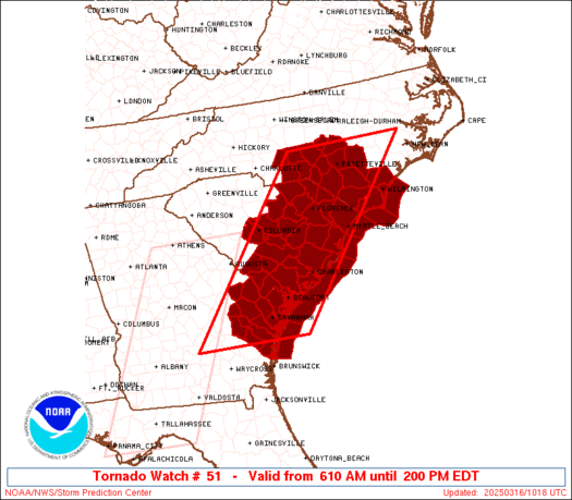
Tornado Watch Number 51
NWS Storm Prediction Center Norman OK
610 AM EDT Sun Mar 16 2025
The NWS Storm Prediction Center has issued a
* Tornado Watch for portions of
Southeast Georgia
Southern North Carolina
Central and Eastern South Carolina
Coastal Waters
* Effective this Sunday morning and afternoon from 610 AM until
200 PM EDT.
* Primary threats include...
A couple tornadoes possible
Scattered damaging wind gusts to 70 mph possible
Isolated large hail events to 0.5 inches in diameter possible
SUMMARY...A broken band of thunderstorms will continue east into the
Watch area this morning within a weakly unstable airmass with very
strong flow aloft. A greater risk for wind damage along with a
threat for a couple of tornadoes, will seemingly focus with
organized bowing segments and perhaps a few embedded circulations
within the band of thunderstorms.
The tornado watch area is approximately along and 80 statute miles
east and west of a line from 35 miles north northeast of
Fayetteville NC to 45 miles southwest of Savannah GA. For a complete
depiction of the watch see the associated watch outline update
(WOUS64 KWNS WOU1).
PRECAUTIONARY/PREPAREDNESS ACTIONS...
REMEMBER...A Tornado Watch means conditions are favorable for
tornadoes and severe thunderstorms in and close to the watch
area. Persons in these areas should be on the lookout for
threatening weather conditions and listen for later statements
and possible warnings.
&&
OTHER WATCH INFORMATION...CONTINUE...WW 50...
AVIATION...Tornadoes and a few severe thunderstorms with hail
surface and aloft to 0.5 inches. Extreme turbulence and surface wind
gusts to 60 knots. A few cumulonimbi with maximum tops to 450. Mean
storm motion vector 25040.
...Smith

   SEL1

   URGENT - IMMEDIATE BROADCAST REQUESTED
   Tornado Watch Number 51
   NWS Storm Prediction Center Norman OK
   610 AM EDT Sun Mar 16 2025

   The NWS Storm Prediction Center has issued a

   * Tornado Watch for portions of
     Southeast Georgia
     Southern North Carolina
     Central and Eastern South Carolina
     Coastal Waters

   * Effective this Sunday morning and afternoon from 610 AM until
     200 PM EDT.

   * Primary threats include...
     A couple tornadoes possible
     Scattered damaging wind gusts to 70 mph possible
     Isolated large hail events to 0.5 inches in diameter possible

   SUMMARY...A broken band of thunderstorms will continue east into the
   Watch area this morning within a weakly unstable airmass with very
   strong flow aloft.  A greater risk for wind damage along with a
   threat for a couple of tornadoes, will seemingly focus with
   organized bowing segments and perhaps a few embedded circulations
   within the band of thunderstorms.

   The tornado watch area is approximately along and 80 statute miles
   east and west of a line from 35 miles north northeast of
   Fayetteville NC to 45 miles southwest of Savannah GA. For a complete
   depiction of the watch see the associated watch outline update
   (WOUS64 KWNS WOU1).

   PRECAUTIONARY/PREPAREDNESS ACTIONS...

   REMEMBER...A Tornado Watch means conditions are favorable for
   tornadoes and severe thunderstorms in and close to the watch
   area. Persons in these areas should be on the lookout for
   threatening weather conditions and listen for later statements
   and possible warnings.

   &&

   OTHER WATCH INFORMATION...CONTINUE...WW 50...

   AVIATION...Tornadoes and a few severe thunderstorms with hail
   surface and aloft to 0.5 inches. Extreme turbulence and surface wind
   gusts to 60 knots. A few cumulonimbi with maximum tops to 450. Mean
   storm motion vector 25040.

   ...Smith
 Note:
The Aviation Watch (SAW) product is an approximation to the watch area.
The actual watch is depicted by the shaded areas.
Note:
The Aviation Watch (SAW) product is an approximation to the watch area.
The actual watch is depicted by the shaded areas.
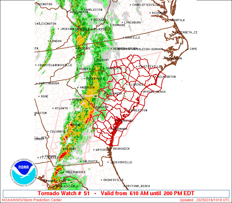
   SAW1
   WW 51 TORNADO GA NC SC CW 161010Z - 161800Z
   AXIS..80 STATUTE MILES EAST AND WEST OF LINE..
   35NNE FAY/FAYETTEVILLE NC/ - 45SW SAV/SAVANNAH GA/
   ..AVIATION COORDS.. 70NM E/W /27SSE RDU - 40ENE AMG/
   HAIL SURFACE AND ALOFT..0.5 INCH. WIND GUSTS..60 KNOTS.
   MAX TOPS TO 450. MEAN STORM MOTION VECTOR 25040.

   LAT...LON 35437722 31668037 31668310 35438006

   THIS IS AN APPROXIMATION TO THE WATCH AREA.  FOR A
   COMPLETE DEPICTION OF THE WATCH SEE WOUS64 KWNS
   FOR WOU1.
Watch 51 Status Report Messages:
STATUS REPORT #4 ON WW 51
VALID 161655Z - 161740Z
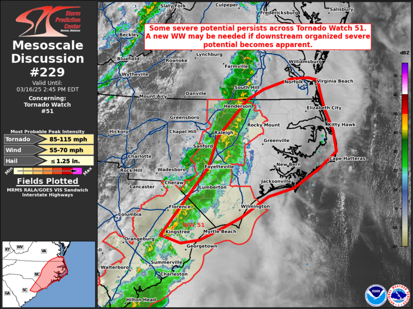
SEVERE WEATHER THREAT CONTINUES RIGHT OF A LINE FROM 40 NE AYS TO
20 SSW FLO TO 10 SSW FAY TO 10 SW RDU.
..LYONS..03/16/25
ATTN...WFO...CHS...RAH...ILM...CAE...
&&
STATUS REPORT FOR WT 51
SEVERE WEATHER THREAT CONTINUES FOR THE FOLLOWING AREAS
GAC029-051-179-191-161740-
GA
. GEORGIA COUNTIES INCLUDED ARE
BRYAN CHATHAM LIBERTY
MCINTOSH
$$
NCC017-019-047-065-069-077-083-101-127-129-141-155-163-181-183-
185-191-195-161740-
NC
. NORTH CAROLINA COUNTIES INCLUDED ARE
BLADEN BRUNSWICK COLUMBUS
EDGECOMBE FRANKLIN GRANVILLE
HALIFAX JOHNSTON NASH
NEW HANOVER PENDER ROBESON
SAMPSON VANCE WAKE
WARREN WAYNE WILSON
$$
SCC013-015-019-027-029-033-035-041-043-051-053-067-089-161740-
SC
. SOUTH CAROLINA COUNTIES INCLUDED ARE
BEAUFORT BERKELEY CHARLESTON
CLARENDON COLLETON DILLON
DORCHESTER FLORENCE GEORGETOWN
HORRY JASPER MARION
WILLIAMSBURG
$$
AMZ250-252-254-256-330-350-352-354-161740-
CW
. ADJACENT COASTAL WATERS INCLUDED ARE
COASTAL WATERS FROM SURF CITY TO CAPE FEAR NC OUT 20 NM
COASTAL WATERS FROM CAPE FEAR NC TO LITTLE RIVER INLET SC OUT 20
NM
COASTAL WATERS FROM LITTLE RIVER INLET TO MURRELLS INLET SC OUT
20 NM
COASTAL WATERS FROM MURRELLS INLET TO SOUTH SANTEE RIVER SC OUT
20 NM
CHARLESTON HARBOR
COASTAL WATERS FROM SOUTH SANTEE RIVER TO EDISTO BEACH SC OUT 20
NM
COASTAL WATERS FROM EDISTO BEACH SC TO SAVANNAH GA OUT 20 NM
COASTAL WATERS FROM SAVANNAH GA TO ALTAMAHA SOUND GA OUT 20 NM
...INCLUDING GRAYS REEF NATIONAL MARINE SANCTUARY
$$
THE WATCH STATUS MESSAGE IS FOR GUIDANCE PURPOSES ONLY. PLEASE
REFER TO WATCH COUNTY NOTIFICATION STATEMENTS FOR OFFICIAL
INFORMATION ON COUNTIES...INDEPENDENT CITIES AND MARINE ZONES
CLEARED FROM SEVERE THUNDERSTORM AND TORNADO WATCHES.
$$
STATUS REPORT #3 ON WW 51
VALID 161550Z - 161640Z
SEVERE WEATHER THREAT CONTINUES RIGHT OF A LINE FROM 40 NE AYS TO
25 ESE SAV TO 35 S OGB TO 35 SSE OGB AND 40 NE AYS TO 20 SSW SAV
TO 30 SSE OGB TO 10 SSW FLO TO 30 NE FLO TO 30 WSW RDU.
..LYONS..03/16/25
ATTN...WFO...CHS...RAH...ILM...CAE...
&&
STATUS REPORT FOR WT 51
SEVERE WEATHER THREAT CONTINUES FOR THE FOLLOWING AREAS
GAC029-051-179-191-161640-
GA
. GEORGIA COUNTIES INCLUDED ARE
BRYAN CHATHAM LIBERTY
MCINTOSH
$$
NCC001-017-019-037-047-051-063-065-069-077-083-085-093-101-105-
125-127-129-135-141-145-155-163-181-183-185-191-195-161640-
NC
. NORTH CAROLINA COUNTIES INCLUDED ARE
ALAMANCE BLADEN BRUNSWICK
CHATHAM COLUMBUS CUMBERLAND
DURHAM EDGECOMBE FRANKLIN
GRANVILLE HALIFAX HARNETT
HOKE JOHNSTON LEE
MOORE NASH NEW HANOVER
ORANGE PENDER PERSON
ROBESON SAMPSON VANCE
WAKE WARREN WAYNE
WILSON
$$
SCC013-015-019-025-027-029-033-035-041-043-051-053-067-069-089-
161640-
SC
. SOUTH CAROLINA COUNTIES INCLUDED ARE
BEAUFORT BERKELEY CHARLESTON
CHESTERFIELD CLARENDON COLLETON
DILLON DORCHESTER FLORENCE
GEORGETOWN HORRY JASPER
MARION MARLBORO WILLIAMSBURG
$$
AMZ250-252-254-256-330-350-352-354-161640-
CW
. ADJACENT COASTAL WATERS INCLUDED ARE
COASTAL WATERS FROM SURF CITY TO CAPE FEAR NC OUT 20 NM
COASTAL WATERS FROM CAPE FEAR NC TO LITTLE RIVER INLET SC OUT 20
NM
COASTAL WATERS FROM LITTLE RIVER INLET TO MURRELLS INLET SC OUT
20 NM
COASTAL WATERS FROM MURRELLS INLET TO SOUTH SANTEE RIVER SC OUT
20 NM
CHARLESTON HARBOR
COASTAL WATERS FROM SOUTH SANTEE RIVER TO EDISTO BEACH SC OUT 20
NM
COASTAL WATERS FROM EDISTO BEACH SC TO SAVANNAH GA OUT 20 NM
COASTAL WATERS FROM SAVANNAH GA TO ALTAMAHA SOUND GA OUT 20 NM
...INCLUDING GRAYS REEF NATIONAL MARINE SANCTUARY
$$
THE WATCH STATUS MESSAGE IS FOR GUIDANCE PURPOSES ONLY. PLEASE
REFER TO WATCH COUNTY NOTIFICATION STATEMENTS FOR OFFICIAL
INFORMATION ON COUNTIES...INDEPENDENT CITIES AND MARINE ZONES
CLEARED FROM SEVERE THUNDERSTORM AND TORNADO WATCHES.
$$
STATUS REPORT #2 ON WW 51
VALID 161405Z - 161540Z
SEVERE WEATHER THREAT CONTINUES RIGHT OF A LINE FROM 45 NW AYS TO
25 S AGS TO 20 WNW OGB TO 5 E CAE TO 40 SSW CLT.
..LYONS..03/16/25
ATTN...WFO...CHS...RAH...ILM...CAE...
&&
STATUS REPORT FOR WT 51
SEVERE WEATHER THREAT CONTINUES FOR THE FOLLOWING AREAS
GAC029-031-043-051-103-109-165-179-183-191-251-267-161540-
GA
. GEORGIA COUNTIES INCLUDED ARE
BRYAN BULLOCH CANDLER
CHATHAM EFFINGHAM EVANS
JENKINS LIBERTY LONG
MCINTOSH SCREVEN TATTNALL
$$
NCC001-007-017-019-037-047-051-057-063-065-067-069-077-081-083-
085-093-101-105-123-125-127-129-135-141-145-151-153-155-163-165-
167-181-183-185-191-195-161540-
NC
. NORTH CAROLINA COUNTIES INCLUDED ARE
ALAMANCE ANSON BLADEN
BRUNSWICK CHATHAM COLUMBUS
CUMBERLAND DAVIDSON DURHAM
EDGECOMBE FORSYTH FRANKLIN
GRANVILLE GUILFORD HALIFAX
HARNETT HOKE JOHNSTON
LEE MONTGOMERY MOORE
NASH NEW HANOVER ORANGE
PENDER PERSON RANDOLPH
RICHMOND ROBESON SAMPSON
SCOTLAND STANLY VANCE
WAKE WARREN WAYNE
WILSON
$$
SCC005-009-011-013-015-017-019-025-027-029-031-033-035-041-043-
049-051-053-061-067-069-075-085-089-161540-
SC
. SOUTH CAROLINA COUNTIES INCLUDED ARE
ALLENDALE BAMBERG BARNWELL
BEAUFORT BERKELEY CALHOUN
CHARLESTON CHESTERFIELD CLARENDON
COLLETON DARLINGTON DILLON
DORCHESTER FLORENCE GEORGETOWN
HAMPTON HORRY JASPER
LEE MARION MARLBORO
ORANGEBURG SUMTER WILLIAMSBURG
$$
AMZ250-252-254-256-330-350-352-354-161540-
CW
. ADJACENT COASTAL WATERS INCLUDED ARE
COASTAL WATERS FROM SURF CITY TO CAPE FEAR NC OUT 20 NM
COASTAL WATERS FROM CAPE FEAR NC TO LITTLE RIVER INLET SC OUT 20
NM
COASTAL WATERS FROM LITTLE RIVER INLET TO MURRELLS INLET SC OUT
20 NM
COASTAL WATERS FROM MURRELLS INLET TO SOUTH SANTEE RIVER SC OUT
20 NM
CHARLESTON HARBOR
COASTAL WATERS FROM SOUTH SANTEE RIVER TO EDISTO BEACH SC OUT 20
NM
COASTAL WATERS FROM EDISTO BEACH SC TO SAVANNAH GA OUT 20 NM
COASTAL WATERS FROM SAVANNAH GA TO ALTAMAHA SOUND GA OUT 20 NM
...INCLUDING GRAYS REEF NATIONAL MARINE SANCTUARY
$$
THE WATCH STATUS MESSAGE IS FOR GUIDANCE PURPOSES ONLY. PLEASE
REFER TO WATCH COUNTY NOTIFICATION STATEMENTS FOR OFFICIAL
INFORMATION ON COUNTIES...INDEPENDENT CITIES AND MARINE ZONES
CLEARED FROM SEVERE THUNDERSTORM AND TORNADO WATCHES.
$$
STATUS REPORT #1 ON WW 51
VALID 161405Z - 161540Z
SEVERE WEATHER THREAT CONTINUES RIGHT OF A LINE FROM 45 NW AYS TO
25 S AGS TO 20 WNW OGB TO 5 E CAE TO 40 SSW CLT.
..LYONS..03/16/25
ATTN...WFO...CHS...RAH...ILM...CAE...
&&
STATUS REPORT FOR WT 51
SEVERE WEATHER THREAT CONTINUES FOR THE FOLLOWING AREAS
GAC029-031-043-051-103-109-165-179-183-191-251-267-161540-
GA
. GEORGIA COUNTIES INCLUDED ARE
BRYAN BULLOCH CANDLER
CHATHAM EFFINGHAM EVANS
JENKINS LIBERTY LONG
MCINTOSH SCREVEN TATTNALL
$$
NCC001-007-017-019-037-047-051-057-063-065-067-069-077-081-083-
085-093-101-105-123-125-127-129-135-141-145-151-153-155-163-165-
167-181-183-185-191-195-161540-
NC
. NORTH CAROLINA COUNTIES INCLUDED ARE
ALAMANCE ANSON BLADEN
BRUNSWICK CHATHAM COLUMBUS
CUMBERLAND DAVIDSON DURHAM
EDGECOMBE FORSYTH FRANKLIN
GRANVILLE GUILFORD HALIFAX
HARNETT HOKE JOHNSTON
LEE MONTGOMERY MOORE
NASH NEW HANOVER ORANGE
PENDER PERSON RANDOLPH
RICHMOND ROBESON SAMPSON
SCOTLAND STANLY VANCE
WAKE WARREN WAYNE
WILSON
$$
SCC005-009-011-013-015-017-019-025-027-029-031-033-035-041-043-
049-051-053-061-067-069-075-085-089-161540-
SC
. SOUTH CAROLINA COUNTIES INCLUDED ARE
ALLENDALE BAMBERG BARNWELL
BEAUFORT BERKELEY CALHOUN
CHARLESTON CHESTERFIELD CLARENDON
COLLETON DARLINGTON DILLON
DORCHESTER FLORENCE GEORGETOWN
HAMPTON HORRY JASPER
LEE MARION MARLBORO
ORANGEBURG SUMTER WILLIAMSBURG
$$
AMZ250-252-254-256-330-350-352-354-161540-
CW
. ADJACENT COASTAL WATERS INCLUDED ARE
COASTAL WATERS FROM SURF CITY TO CAPE FEAR NC OUT 20 NM
COASTAL WATERS FROM CAPE FEAR NC TO LITTLE RIVER INLET SC OUT 20
NM
COASTAL WATERS FROM LITTLE RIVER INLET TO MURRELLS INLET SC OUT
20 NM
COASTAL WATERS FROM MURRELLS INLET TO SOUTH SANTEE RIVER SC OUT
20 NM
CHARLESTON HARBOR
COASTAL WATERS FROM SOUTH SANTEE RIVER TO EDISTO BEACH SC OUT 20
NM
COASTAL WATERS FROM EDISTO BEACH SC TO SAVANNAH GA OUT 20 NM
COASTAL WATERS FROM SAVANNAH GA TO ALTAMAHA SOUND GA OUT 20 NM
...INCLUDING GRAYS REEF NATIONAL MARINE SANCTUARY
$$
THE WATCH STATUS MESSAGE IS FOR GUIDANCE PURPOSES ONLY. PLEASE
REFER TO WATCH COUNTY NOTIFICATION STATEMENTS FOR OFFICIAL
INFORMATION ON COUNTIES...INDEPENDENT CITIES AND MARINE ZONES
CLEARED FROM SEVERE THUNDERSTORM AND TORNADO WATCHES.
$$
Note:
Click for Complete Product Text.
Tornadoes
Probability of 2 or more tornadoes
|
Mod (40%)
|
Probability of 1 or more strong (EF2-EF5) tornadoes
|
Low (20%)
|
Wind
Probability of 10 or more severe wind events
|
Mod (50%)
|
Probability of 1 or more wind events > 65 knots
|
Low (20%)
|
Hail
Probability of 10 or more severe hail events
|
Low (20%)
|
Probability of 1 or more hailstones > 2 inches
|
Low (10%)
|
Combined Severe Hail/Wind
Probability of 6 or more combined severe hail/wind events
|
High (70%)
|
For each watch, probabilities for particular events inside the watch
(listed above in each table) are determined by the issuing forecaster.
The "Low" category contains probability values ranging from less than 2%
to 20% (EF2-EF5 tornadoes), less than 5% to 20% (all other probabilities),
"Moderate" from 30% to 60%, and "High" from 70% to greater than 95%.
High values are bolded and lighter in color to provide awareness of
an increased threat for a particular event.


 @NWSSPC