Note:
The expiration time in the watch graphic is amended if the watch is
replaced, cancelled or extended.
Note:
Note:
The expiration time in the watch graphic is amended if the watch is
replaced, cancelled or extended.
Note: Click for
Watch Status Reports.
SEL6
URGENT - IMMEDIATE BROADCAST REQUESTED
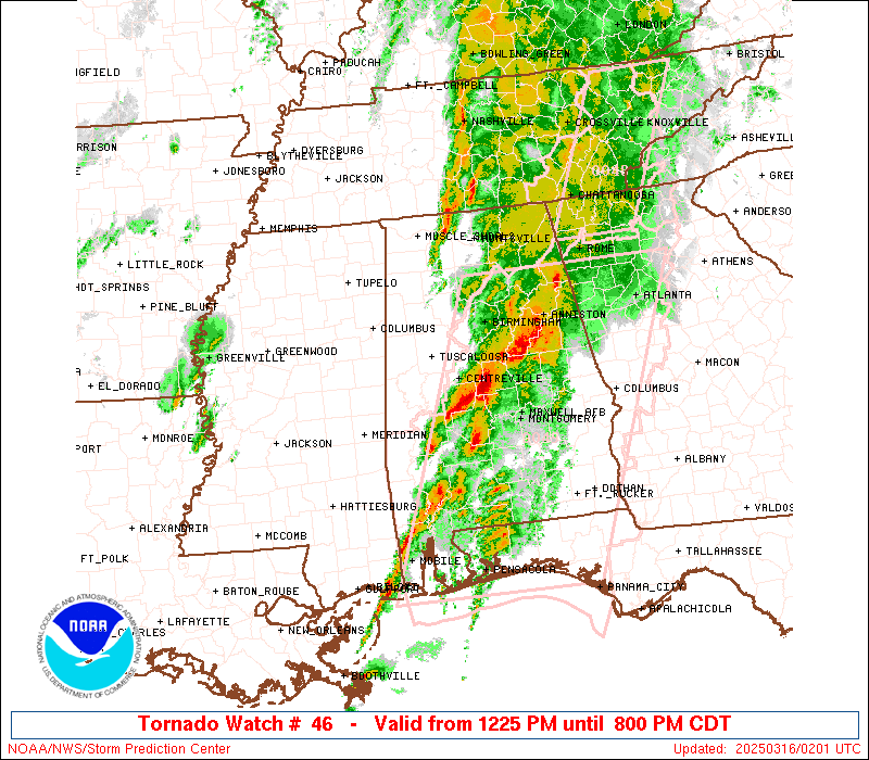
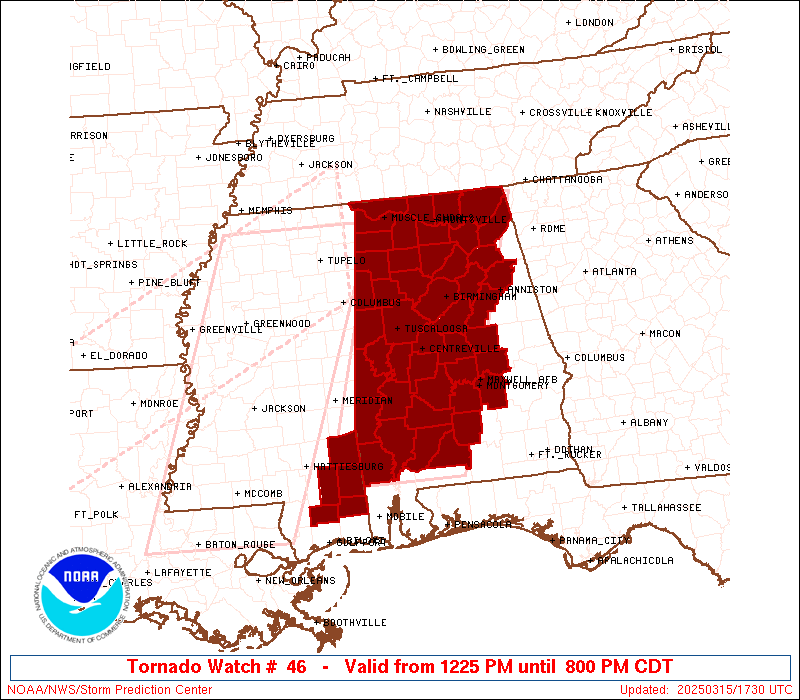
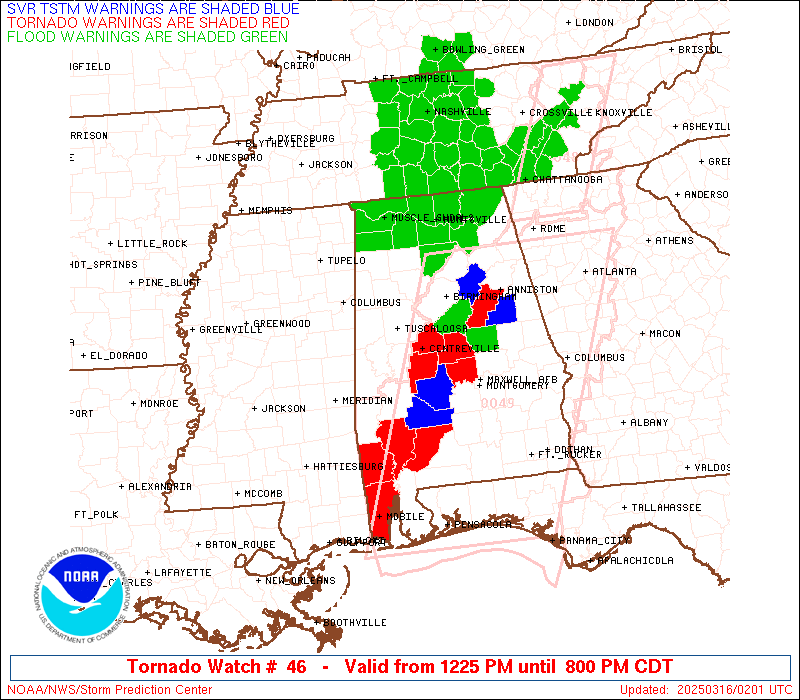
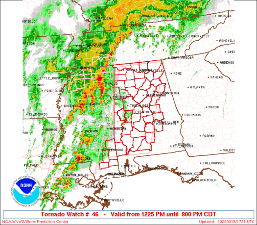
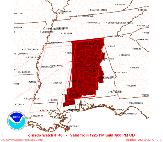
Tornado Watch Number 46
NWS Storm Prediction Center Norman OK
1225 PM CDT Sat Mar 15 2025
The NWS Storm Prediction Center has issued a
* Tornado Watch for portions of
Western, Central, and Northern Alabama
Southeast Mississippi
* Effective this Saturday afternoon and evening from 1225 PM
until 800 PM CDT.
...THIS IS A PARTICULARLY DANGEROUS SITUATION...
* Primary threats include...
Numerous tornadoes and several intense tornadoes expected
Scattered damaging winds and isolated significant gusts to 75
mph likely
Scattered large hail and isolated very large hail events to 2.5
inches in diameter likely
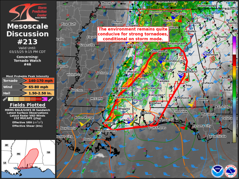
SUMMARY...Intense supercells capable of producing numerous tornadoes
will spread eastward from Mississippi into Alabama this afternoon
and evening. Given the very favorable environment, multiple intense
to potentially violent tornadoes (EF-3/EF-4+) appear possible.
Clusters of thunderstorms and embedded supercells will also pose a
threat for severe/damaging winds of 60-75 mph, and large hail around
1.5-2.5 inches in diameter.
The tornado watch area is approximately along and 65 statute miles
east and west of a line from 20 miles north northeast of Huntsville
AL to 55 miles west southwest of Evergreen AL. For a complete
depiction of the watch see the associated watch outline update
(WOUS64 KWNS WOU6).
PRECAUTIONARY/PREPAREDNESS ACTIONS...
REMEMBER...A Tornado Watch means conditions are favorable for
tornadoes and severe thunderstorms in and close to the watch
area. Persons in these areas should be on the lookout for
threatening weather conditions and listen for later statements
and possible warnings.
&&
OTHER WATCH INFORMATION...CONTINUE...WW 44...WW 45...
AVIATION...Tornadoes and a few severe thunderstorms with hail
surface and aloft to 2.5 inches. Extreme turbulence and surface wind
gusts to 65 knots. A few cumulonimbi with maximum tops to 500. Mean
storm motion vector 23040.
...Gleason
   SEL6

   URGENT - IMMEDIATE BROADCAST REQUESTED
   Tornado Watch Number 46
   NWS Storm Prediction Center Norman OK
   1225 PM CDT Sat Mar 15 2025

   The NWS Storm Prediction Center has issued a

   * Tornado Watch for portions of
     Western, Central, and Northern Alabama
     Southeast Mississippi

   * Effective this Saturday afternoon and evening from 1225 PM
     until 800 PM CDT.

   ...THIS IS A PARTICULARLY DANGEROUS SITUATION...

   * Primary threats include...
     Numerous tornadoes and several intense tornadoes expected
     Scattered damaging winds and isolated significant gusts to 75
       mph likely
     Scattered large hail and isolated very large hail events to 2.5
       inches in diameter likely

   SUMMARY...Intense supercells capable of producing numerous tornadoes
   will spread eastward from Mississippi into Alabama this afternoon
   and evening. Given the very favorable environment, multiple intense
   to potentially violent tornadoes (EF-3/EF-4+) appear possible.
   Clusters of thunderstorms and embedded supercells will also pose a
   threat for severe/damaging winds of 60-75 mph, and large hail around
   1.5-2.5 inches in diameter.

   The tornado watch area is approximately along and 65 statute miles
   east and west of a line from 20 miles north northeast of Huntsville
   AL to 55 miles west southwest of Evergreen AL. For a complete
   depiction of the watch see the associated watch outline update
   (WOUS64 KWNS WOU6).

   PRECAUTIONARY/PREPAREDNESS ACTIONS...

   REMEMBER...A Tornado Watch means conditions are favorable for
   tornadoes and severe thunderstorms in and close to the watch
   area. Persons in these areas should be on the lookout for
   threatening weather conditions and listen for later statements
   and possible warnings.

   &&

   OTHER WATCH INFORMATION...CONTINUE...WW 44...WW 45...

   AVIATION...Tornadoes and a few severe thunderstorms with hail
   surface and aloft to 2.5 inches. Extreme turbulence and surface wind
   gusts to 65 knots. A few cumulonimbi with maximum tops to 500. Mean
   storm motion vector 23040.

   ...Gleason
 Note:
The Aviation Watch (SAW) product is an approximation to the watch area.
The actual watch is depicted by the shaded areas.
Note:
The Aviation Watch (SAW) product is an approximation to the watch area.
The actual watch is depicted by the shaded areas.
   SAW6
   WW 46 TORNADO AL MS 151725Z - 160100Z
   AXIS..65 STATUTE MILES EAST AND WEST OF LINE..
   20NNE HSV/HUNTSVILLE AL/ - 55WSW GZH/EVERGREEN AL/
   ..AVIATION COORDS.. 55NM E/W /43ENE MSL - 33NE SJI/
   HAIL SURFACE AND ALOFT..2.5 INCHES. WIND GUSTS..65 KNOTS.
   MAX TOPS TO 500. MEAN STORM MOTION VECTOR 23040.

   LAT...LON 34918550 31118680 31118900 34918779

   THIS IS AN APPROXIMATION TO THE WATCH AREA.  FOR A
   COMPLETE DEPICTION OF THE WATCH SEE WOUS64 KWNS
   FOR WOU6.
Watch 46 Status Report Messages:
STATUS REPORT #4 ON WW 46

VALID 152150Z - 152240Z

THE SEVERE WEATHER THREAT CONTINUES ACROSS THE ENTIRE WATCH AREA.

..LYONS..03/15/25

ATTN...WFO...BMX...MOB...HUN...

&&

STATUS REPORT FOR WT 46

SEVERE WEATHER THREAT CONTINUES FOR THE FOLLOWING AREAS

ALC001-007-009-013-015-021-023-025-033-035-037-043-047-049-051-
055-057-059-063-065-071-073-075-077-079-083-085-089-091-093-095-
099-101-103-105-107-115-117-119-121-125-127-129-131-133-
152240-

AL
.    ALABAMA COUNTIES INCLUDED ARE

AUTAUGA 	     BIBB		 BLOUNT
BUTLER		     CALHOUN		 CHILTON
CHOCTAW 	     CLARKE		 COLBERT
CONECUH 	     COOSA		 CULLMAN
DALLAS		     DEKALB		 ELMORE
ETOWAH		     FAYETTE		 FRANKLIN
GREENE		     HALE		 JACKSON
JEFFERSON	     LAMAR		 LAUDERDALE
LAWRENCE	     LIMESTONE		 LOWNDES
MADISON 	     MARENGO		 MARION
MARSHALL	     MONROE		 MONTGOMERY
MORGAN		     PERRY		 PICKENS
ST. CLAIR	     SHELBY		 SUMTER
TALLADEGA	     TUSCALOOSA 	 WALKER
WASHINGTON	     WILCOX		 WINSTON
$$


MSC039-041-111-131-153-152240-

MS
.    MISSISSIPPI COUNTIES INCLUDED ARE

GEORGE		     GREENE		 PERRY
STONE		     WAYNE
$$


THE WATCH STATUS MESSAGE IS FOR GUIDANCE PURPOSES ONLY.  PLEASE
REFER TO WATCH COUNTY NOTIFICATION STATEMENTS FOR OFFICIAL
INFORMATION ON COUNTIES...INDEPENDENT CITIES AND MARINE ZONES
CLEARED FROM SEVERE THUNDERSTORM AND TORNADO WATCHES.
$$

STATUS REPORT #3 ON WW 46

VALID 152030Z - 152140Z

THE SEVERE WEATHER THREAT CONTINUES ACROSS THE ENTIRE WATCH AREA.

..GRAMS..03/15/25

ATTN...WFO...BMX...MOB...HUN...

&&

STATUS REPORT FOR WT 46

SEVERE WEATHER THREAT CONTINUES FOR THE FOLLOWING AREAS

ALC001-007-009-013-015-021-023-025-033-035-037-043-047-049-051-
055-057-059-063-065-071-073-075-077-079-083-085-089-091-093-095-
099-101-103-105-107-115-117-119-121-125-127-129-131-133-
152140-

AL
.    ALABAMA COUNTIES INCLUDED ARE

AUTAUGA 	     BIBB		 BLOUNT
BUTLER		     CALHOUN		 CHILTON
CHOCTAW 	     CLARKE		 COLBERT
CONECUH 	     COOSA		 CULLMAN
DALLAS		     DEKALB		 ELMORE
ETOWAH		     FAYETTE		 FRANKLIN
GREENE		     HALE		 JACKSON
JEFFERSON	     LAMAR		 LAUDERDALE
LAWRENCE	     LIMESTONE		 LOWNDES
MADISON 	     MARENGO		 MARION
MARSHALL	     MONROE		 MONTGOMERY
MORGAN		     PERRY		 PICKENS
ST. CLAIR	     SHELBY		 SUMTER
TALLADEGA	     TUSCALOOSA 	 WALKER
WASHINGTON	     WILCOX		 WINSTON
$$


MSC039-041-111-131-153-152140-

MS
.    MISSISSIPPI COUNTIES INCLUDED ARE

GEORGE		     GREENE		 PERRY
STONE		     WAYNE
$$


THE WATCH STATUS MESSAGE IS FOR GUIDANCE PURPOSES ONLY.  PLEASE
REFER TO WATCH COUNTY NOTIFICATION STATEMENTS FOR OFFICIAL
INFORMATION ON COUNTIES...INDEPENDENT CITIES AND MARINE ZONES
CLEARED FROM SEVERE THUNDERSTORM AND TORNADO WATCHES.
$$

STATUS REPORT #2 ON WW 46

VALID 151930Z - 152040Z

THE SEVERE WEATHER THREAT CONTINUES ACROSS THE ENTIRE WATCH AREA.

FOR ADDITIONAL INFORMATION SEE MESOSCALE DISCUSSIONS 0206 AND 0207.

..GRAMS..03/15/25

ATTN...WFO...BMX...MOB...HUN...

&&

STATUS REPORT FOR WT 46

SEVERE WEATHER THREAT CONTINUES FOR THE FOLLOWING AREAS

ALC001-007-009-013-015-021-023-025-033-035-037-043-047-049-051-
055-057-059-063-065-071-073-075-077-079-083-085-089-091-093-095-
099-101-103-105-107-115-117-119-121-125-127-129-131-133-
152040-

AL
.    ALABAMA COUNTIES INCLUDED ARE

AUTAUGA 	     BIBB		 BLOUNT
BUTLER		     CALHOUN		 CHILTON
CHOCTAW 	     CLARKE		 COLBERT
CONECUH 	     COOSA		 CULLMAN
DALLAS		     DEKALB		 ELMORE
ETOWAH		     FAYETTE		 FRANKLIN
GREENE		     HALE		 JACKSON
JEFFERSON	     LAMAR		 LAUDERDALE
LAWRENCE	     LIMESTONE		 LOWNDES
MADISON 	     MARENGO		 MARION
MARSHALL	     MONROE		 MONTGOMERY
MORGAN		     PERRY		 PICKENS
ST. CLAIR	     SHELBY		 SUMTER
TALLADEGA	     TUSCALOOSA 	 WALKER
WASHINGTON	     WILCOX		 WINSTON
$$


MSC039-041-111-131-153-152040-

MS
.    MISSISSIPPI COUNTIES INCLUDED ARE

GEORGE		     GREENE		 PERRY
STONE		     WAYNE
$$


THE WATCH STATUS MESSAGE IS FOR GUIDANCE PURPOSES ONLY.  PLEASE
REFER TO WATCH COUNTY NOTIFICATION STATEMENTS FOR OFFICIAL
INFORMATION ON COUNTIES...INDEPENDENT CITIES AND MARINE ZONES
CLEARED FROM SEVERE THUNDERSTORM AND TORNADO WATCHES.
$$

STATUS REPORT #1 ON WW 46

VALID 151825Z - 151940Z

THE SEVERE WEATHER THREAT CONTINUES ACROSS THE ENTIRE WATCH AREA.

..THORNTON..03/15/25

ATTN...WFO...BMX...MOB...HUN...

&&

STATUS REPORT FOR WT 46

SEVERE WEATHER THREAT CONTINUES FOR THE FOLLOWING AREAS

ALC001-007-009-013-015-021-023-025-033-035-037-043-047-049-051-
055-057-059-063-065-071-073-075-077-079-083-085-089-091-093-095-
099-101-103-105-107-115-117-119-121-125-127-129-131-133-
151940-

AL
.    ALABAMA COUNTIES INCLUDED ARE

AUTAUGA 	     BIBB		 BLOUNT
BUTLER		     CALHOUN		 CHILTON
CHOCTAW 	     CLARKE		 COLBERT
CONECUH 	     COOSA		 CULLMAN
DALLAS		     DEKALB		 ELMORE
ETOWAH		     FAYETTE		 FRANKLIN
GREENE		     HALE		 JACKSON
JEFFERSON	     LAMAR		 LAUDERDALE
LAWRENCE	     LIMESTONE		 LOWNDES
MADISON 	     MARENGO		 MARION
MARSHALL	     MONROE		 MONTGOMERY
MORGAN		     PERRY		 PICKENS
ST. CLAIR	     SHELBY		 SUMTER
TALLADEGA	     TUSCALOOSA 	 WALKER
WASHINGTON	     WILCOX		 WINSTON
$$


MSC039-041-111-131-153-151940-

MS
.    MISSISSIPPI COUNTIES INCLUDED ARE

GEORGE		     GREENE		 PERRY
STONE		     WAYNE
$$


THE WATCH STATUS MESSAGE IS FOR GUIDANCE PURPOSES ONLY.  PLEASE
REFER TO WATCH COUNTY NOTIFICATION STATEMENTS FOR OFFICIAL
INFORMATION ON COUNTIES...INDEPENDENT CITIES AND MARINE ZONES
CLEARED FROM SEVERE THUNDERSTORM AND TORNADO WATCHES.
$$
Note:
Click for Complete Product Text.
Tornadoes
Probability of 2 or more tornadoes
|
High (>95%)
|
Probability of 1 or more strong (EF2-EF5) tornadoes
|
High (>95%)
|
Wind
Probability of 10 or more severe wind events
|
High (70%)
|
Probability of 1 or more wind events > 65 knots
|
Mod (60%)
|
Hail
Probability of 10 or more severe hail events
|
High (70%)
|
Probability of 1 or more hailstones > 2 inches
|
Mod (60%)
|
Combined Severe Hail/Wind
Probability of 6 or more combined severe hail/wind events
|
High (>95%)
|
For each watch, probabilities for particular events inside the watch
(listed above in each table) are determined by the issuing forecaster.
The "Low" category contains probability values ranging from less than 2%
to 20% (EF2-EF5 tornadoes), less than 5% to 20% (all other probabilities),
"Moderate" from 30% to 60%, and "High" from 70% to greater than 95%.
High values are bolded and lighter in color to provide awareness of
an increased threat for a particular event.


 @NWSSPC