 Note:
The expiration time in the watch graphic is amended if the watch is
replaced, cancelled or extended.
Note:
Note:
The expiration time in the watch graphic is amended if the watch is
replaced, cancelled or extended.
Note: Click for
Watch Status Reports.
SEL6
URGENT - IMMEDIATE BROADCAST REQUESTED
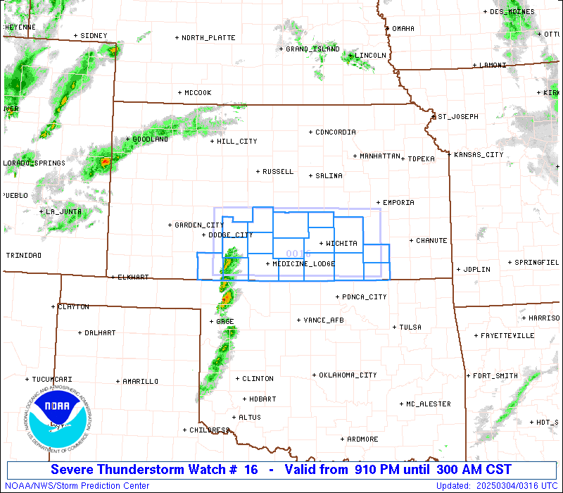
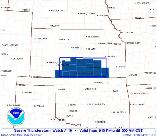
Severe Thunderstorm Watch Number 16
NWS Storm Prediction Center Norman OK
910 PM CST Mon Mar 3 2025
The NWS Storm Prediction Center has issued a
* Severe Thunderstorm Watch for portions of
Southern Kansas
* Effective this Monday night and Tuesday morning from 910 PM
until 300 AM CST.
* Primary threats include...
Scattered large hail events to 1.5 inches in diameter possible
Isolated damaging wind gusts to 60 mph possible
A tornado or two possible
SUMMARY...Storms are expected to increase and develop eastward
across southern Kansas through the late evening and overnight, with
bouts of large hail and locally damaging winds as the primary
hazards.
The severe thunderstorm watch area is approximately along and 40
statute miles north and south of a line from 70 miles west northwest
of Medicine Lodge KS to 70 miles east of Wichita KS. For a complete
depiction of the watch see the associated watch outline update
(WOUS64 KWNS WOU6).
PRECAUTIONARY/PREPAREDNESS ACTIONS...
REMEMBER...A Severe Thunderstorm Watch means conditions are
favorable for severe thunderstorms in and close to the watch area.
Persons in these areas should be on the lookout for threatening
weather conditions and listen for later statements and possible
warnings. Severe thunderstorms can and occasionally do produce
tornadoes.
&&
AVIATION...A few severe thunderstorms with hail surface and aloft to
1.5 inches. Extreme turbulence and surface wind gusts to 50 knots. A
few cumulonimbi with maximum tops to 500. Mean storm motion vector
24030.
...Guyer

   SEL6

   URGENT - IMMEDIATE BROADCAST REQUESTED
   Severe Thunderstorm Watch Number 16
   NWS Storm Prediction Center Norman OK
   910 PM CST Mon Mar 3 2025

   The NWS Storm Prediction Center has issued a

   * Severe Thunderstorm Watch for portions of
     Southern Kansas

   * Effective this Monday night and Tuesday morning from 910 PM
     until 300 AM CST.

   * Primary threats include...
     Scattered large hail events to 1.5 inches in diameter possible
     Isolated damaging wind gusts to 60 mph possible
     A tornado or two possible

   SUMMARY...Storms are expected to increase and develop eastward
   across southern Kansas through the late evening and overnight, with
   bouts of large hail and locally damaging winds as the primary
   hazards.

   The severe thunderstorm watch area is approximately along and 40
   statute miles north and south of a line from 70 miles west northwest
   of Medicine Lodge KS to 70 miles east of Wichita KS. For a complete
   depiction of the watch see the associated watch outline update
   (WOUS64 KWNS WOU6).

   PRECAUTIONARY/PREPAREDNESS ACTIONS...

   REMEMBER...A Severe Thunderstorm Watch means conditions are
   favorable for severe thunderstorms in and close to the watch area.
   Persons in these areas should be on the lookout for threatening
   weather conditions and listen for later statements and possible
   warnings. Severe thunderstorms can and occasionally do produce
   tornadoes.

   &&

   AVIATION...A few severe thunderstorms with hail surface and aloft to
   1.5 inches. Extreme turbulence and surface wind gusts to 50 knots. A
   few cumulonimbi with maximum tops to 500. Mean storm motion vector
   24030.

   ...Guyer
 Note:
The Aviation Watch (SAW) product is an approximation to the watch area.
The actual watch is depicted by the shaded areas.
Note:
The Aviation Watch (SAW) product is an approximation to the watch area.
The actual watch is depicted by the shaded areas.
   SAW6
   WW 16 SEVERE TSTM KS 040310Z - 040900Z
   AXIS..40 STATUTE MILES NORTH AND SOUTH OF LINE..
   70WNW P28/MEDICINE LODGE KS/ - 70E ICT/WICHITA KS/
   ..AVIATION COORDS.. 35NM N/S /48ESE GCK - 54WNW OSW/
   HAIL SURFACE AND ALOFT..1.5 INCHES. WIND GUSTS..50 KNOTS.
   MAX TOPS TO 500. MEAN STORM MOTION VECTOR 24030.

   LAT...LON 38259976 38229615 37069615 37099976

   THIS IS AN APPROXIMATION TO THE WATCH AREA.  FOR A
   COMPLETE DEPICTION OF THE WATCH SEE WOUS64 KWNS
   FOR WOU6.
Watch 16 Status Report Messages:
STATUS REPORT #3 ON WW 16

VALID 040635Z - 040900Z

SEVERE WEATHER THREAT CONTINUES RIGHT OF A LINE FROM 25 NNW PNC
TO 35 WNW CNU.

WW 16 WILL BE ALLOWED TO EXPIRE AT 040900Z.

..JEWELL..03/04/25

ATTN...WFO...DDC...ICT...

&&

STATUS REPORT FOR WS 16

SEVERE WEATHER THREAT CONTINUES FOR THE FOLLOWING AREAS

KSC019-035-049-040900-

KS
.    KANSAS COUNTIES INCLUDED ARE

CHAUTAUQUA	     COWLEY		 ELK
$$


THE WATCH STATUS MESSAGE IS FOR GUIDANCE PURPOSES ONLY.  PLEASE
REFER TO WATCH COUNTY NOTIFICATION STATEMENTS FOR OFFICIAL
INFORMATION ON COUNTIES...INDEPENDENT CITIES AND MARINE ZONES
CLEARED FROM SEVERE THUNDERSTORM AND TORNADO WATCHES.
$$

STATUS REPORT #2 ON WW 16

VALID 040540Z - 040640Z

SEVERE WEATHER THREAT CONTINUES RIGHT OF A LINE FROM 25 ENE AVK
TO 15 NNE HUT.

..LEITMAN..03/04/25

ATTN...WFO...DDC...ICT...

&&

STATUS REPORT FOR WS 16

SEVERE WEATHER THREAT CONTINUES FOR THE FOLLOWING AREAS

KSC015-019-035-049-077-079-095-155-173-191-040640-

KS
.    KANSAS COUNTIES INCLUDED ARE

BUTLER		     CHAUTAUQUA 	 COWLEY
ELK		     HARPER		 HARVEY
KINGMAN 	     RENO		 SEDGWICK
SUMNER
$$


THE WATCH STATUS MESSAGE IS FOR GUIDANCE PURPOSES ONLY.  PLEASE
REFER TO WATCH COUNTY NOTIFICATION STATEMENTS FOR OFFICIAL
INFORMATION ON COUNTIES...INDEPENDENT CITIES AND MARINE ZONES
CLEARED FROM SEVERE THUNDERSTORM AND TORNADO WATCHES.
$$

STATUS REPORT #1 ON WW 16

VALID 040430Z - 040540Z

SEVERE WEATHER THREAT CONTINUES RIGHT OF A LINE FROM 20 NW AVK TO
40 SSE RSL.

..LEITMAN..03/04/25

ATTN...WFO...DDC...ICT...

&&

STATUS REPORT FOR WS 16

SEVERE WEATHER THREAT CONTINUES FOR THE FOLLOWING AREAS

KSC007-015-019-035-049-077-079-095-151-155-173-185-191-040540-

KS
.    KANSAS COUNTIES INCLUDED ARE

BARBER		     BUTLER		 CHAUTAUQUA
COWLEY		     ELK		 HARPER
HARVEY		     KINGMAN		 PRATT
RENO		     SEDGWICK		 STAFFORD
SUMNER
$$


THE WATCH STATUS MESSAGE IS FOR GUIDANCE PURPOSES ONLY.  PLEASE
REFER TO WATCH COUNTY NOTIFICATION STATEMENTS FOR OFFICIAL
INFORMATION ON COUNTIES...INDEPENDENT CITIES AND MARINE ZONES
CLEARED FROM SEVERE THUNDERSTORM AND TORNADO WATCHES.
$$
Note:
Click for Complete Product Text.
Tornadoes
Probability of 2 or more tornadoes
|
Low (20%)
|
Probability of 1 or more strong (EF2-EF5) tornadoes
|
Low (5%)
|
Wind
Probability of 10 or more severe wind events
|
Mod (30%)
|
Probability of 1 or more wind events > 65 knots
|
Low (<5%)
|
Hail
Probability of 10 or more severe hail events
|
Mod (40%)
|
Probability of 1 or more hailstones > 2 inches
|
Low (10%)
|
Combined Severe Hail/Wind
Probability of 6 or more combined severe hail/wind events
|
High (80%)
|
For each watch, probabilities for particular events inside the watch
(listed above in each table) are determined by the issuing forecaster.
The "Low" category contains probability values ranging from less than 2%
to 20% (EF2-EF5 tornadoes), less than 5% to 20% (all other probabilities),
"Moderate" from 30% to 60%, and "High" from 70% to greater than 95%.
High values are bolded and lighter in color to provide awareness of
an increased threat for a particular event.


 @NWSSPC