 Note:
The expiration time in the watch graphic is amended if the watch is
replaced, cancelled or extended.
Note:
Note:
The expiration time in the watch graphic is amended if the watch is
replaced, cancelled or extended.
Note: Click for
Watch Status Reports.
SEL5
URGENT - IMMEDIATE BROADCAST REQUESTED
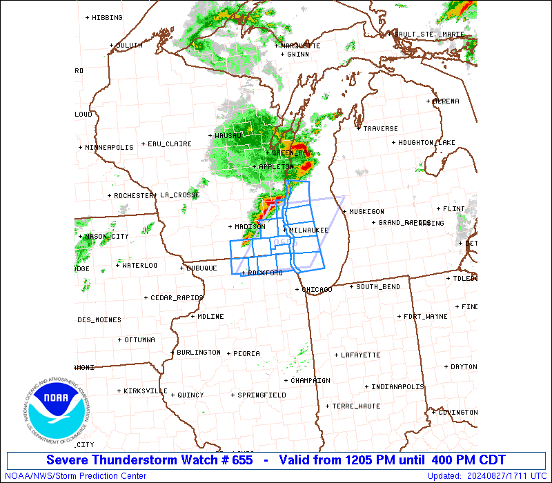
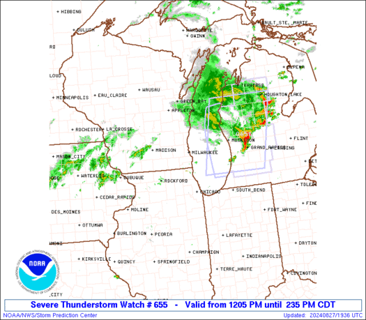
Severe Thunderstorm Watch Number 655
NWS Storm Prediction Center Norman OK
1205 PM CDT Tue Aug 27 2024
The NWS Storm Prediction Center has issued a
* Severe Thunderstorm Watch for portions of
Northern Illinois
Southeast Wisconsin
Lake Michigan
* Effective this Tuesday afternoon from 1205 PM until 400 PM CDT.
* Primary threats include...
Scattered damaging wind gusts to 70 mph possible
Scattered large hail events to 1.5 inches in diameter possible
SUMMARY...Clusters of severe storms will continue to move across
southeast Wisconsin early this afternoon, with additional
development possible into northern Illinois.
The severe thunderstorm watch area is approximately along and 50
statute miles east and west of a line from 50 miles northeast of
Milwaukee WI to 40 miles east of Rockford IL. For a complete
depiction of the watch see the associated watch outline update
(WOUS64 KWNS WOU5).
PRECAUTIONARY/PREPAREDNESS ACTIONS...
REMEMBER...A Severe Thunderstorm Watch means conditions are
favorable for severe thunderstorms in and close to the watch area.
Persons in these areas should be on the lookout for threatening
weather conditions and listen for later statements and possible
warnings. Severe thunderstorms can and occasionally do produce
tornadoes.
&&
AVIATION...A few severe thunderstorms with hail surface and aloft to
1.5 inches. Extreme turbulence and surface wind gusts to 60 knots. A
few cumulonimbi with maximum tops to 550. Mean storm motion vector
28025.
...Guyer
   SEL5

   URGENT - IMMEDIATE BROADCAST REQUESTED
   Severe Thunderstorm Watch Number 655
   NWS Storm Prediction Center Norman OK
   1205 PM CDT Tue Aug 27 2024

   The NWS Storm Prediction Center has issued a

   * Severe Thunderstorm Watch for portions of
     Northern Illinois
     Southeast Wisconsin
     Lake Michigan

   * Effective this Tuesday afternoon from 1205 PM until 400 PM CDT.

   * Primary threats include...
     Scattered damaging wind gusts to 70 mph possible
     Scattered large hail events to 1.5 inches in diameter possible

   SUMMARY...Clusters of severe storms will continue to move across
   southeast Wisconsin early this afternoon, with additional
   development possible into northern Illinois.

   The severe thunderstorm watch area is approximately along and 50
   statute miles east and west of a line from 50 miles northeast of
   Milwaukee WI to 40 miles east of Rockford IL. For a complete
   depiction of the watch see the associated watch outline update
   (WOUS64 KWNS WOU5).

   PRECAUTIONARY/PREPAREDNESS ACTIONS...

   REMEMBER...A Severe Thunderstorm Watch means conditions are
   favorable for severe thunderstorms in and close to the watch area.
   Persons in these areas should be on the lookout for threatening
   weather conditions and listen for later statements and possible
   warnings. Severe thunderstorms can and occasionally do produce
   tornadoes.

   &&

   AVIATION...A few severe thunderstorms with hail surface and aloft to
   1.5 inches. Extreme turbulence and surface wind gusts to 60 knots. A
   few cumulonimbi with maximum tops to 550. Mean storm motion vector
   28025.

   ...Guyer
 Note:
The Aviation Watch (SAW) product is an approximation to the watch area.
The actual watch is depicted by the shaded areas.
Note:
The Aviation Watch (SAW) product is an approximation to the watch area.
The actual watch is depicted by the shaded areas.
SAW5
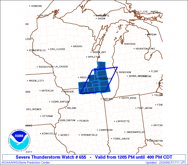
WW 655 SEVERE TSTM IL WI LM 271705Z - 272100Z
AXIS..50 STATUTE MILES EAST AND WEST OF LINE..
50NE MKE/MILWAUKEE WI/ - 40E RFD/ROCKFORD IL/
..AVIATION COORDS.. 45NM E/W /52ENE BAE - 23NW ORD/
HAIL SURFACE AND ALOFT..1.5 INCHES. WIND GUSTS..60 KNOTS.
MAX TOPS TO 550. MEAN STORM MOTION VECTOR 28025.
LAT...LON 43468620 42198734 42198930 43468819
THIS IS AN APPROXIMATION TO THE WATCH AREA. FOR A
COMPLETE DEPICTION OF THE WATCH SEE WOUS64 KWNS
FOR WOU5.
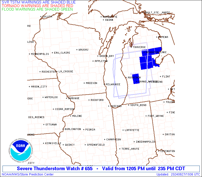
Watch 655 Status Report Messages:
STATUS REPORT #1 ON WW 655

VALID 271900Z - 272040Z

SEVERE WEATHER THREAT CONTINUES RIGHT OF A LINE FROM 10 WSW RFD
TO 15 SSE JVL TO 35 NW BEH.

..JEWELL..08/27/24

ATTN...WFO...LOT...MKX...

&&

STATUS REPORT FOR WS 655

SEVERE WEATHER THREAT CONTINUES FOR THE FOLLOWING AREAS

ILC007-097-111-272040-

IL
.    ILLINOIS COUNTIES INCLUDED ARE

BOONE		     LAKE		 MCHENRY
$$


LMZ740-777-272040-

CW

.    ADJACENT COASTAL WATERS INCLUDED ARE

WINTHROP HARBOR TO WILMETTE HARBOR IL

LAKE MICHIGAN FROM WINTHROP HARBOR TO WILMETTE HARBOR IL 5NM
OFFSHORE TO MID LAKE

$$
THE WATCH STATUS MESSAGE IS FOR GUIDANCE PURPOSES ONLY.  PLEASE
REFER TO WATCH COUNTY NOTIFICATION STATEMENTS FOR OFFICIAL
INFORMATION ON COUNTIES...INDEPENDENT CITIES AND MARINE ZONES
CLEARED FROM SEVERE THUNDERSTORM AND TORNADO WATCHES.
$$
Note:
Click for Complete Product Text.
Tornadoes
Probability of 2 or more tornadoes
|
Low (10%)
|
Probability of 1 or more strong (EF2-EF5) tornadoes
|
Low (10%)
|
Wind
Probability of 10 or more severe wind events
|
Mod (50%)
|
Probability of 1 or more wind events > 65 knots
|
Low (20%)
|
Hail
Probability of 10 or more severe hail events
|
Mod (40%)
|
Probability of 1 or more hailstones > 2 inches
|
Low (20%)
|
Combined Severe Hail/Wind
Probability of 6 or more combined severe hail/wind events
|
High (90%)
|
For each watch, probabilities for particular events inside the watch
(listed above in each table) are determined by the issuing forecaster.
The "Low" category contains probability values ranging from less than 2%
to 20% (EF2-EF5 tornadoes), less than 5% to 20% (all other probabilities),
"Moderate" from 30% to 60%, and "High" from 70% to greater than 95%.
High values are bolded and lighter in color to provide awareness of
an increased threat for a particular event.


 @NWSSPC