 Note:
The expiration time in the watch graphic is amended if the watch is
replaced, cancelled or extended.
Note:
Note:
The expiration time in the watch graphic is amended if the watch is
replaced, cancelled or extended.
Note: Click for
Watch Status Reports.
SEL5
URGENT - IMMEDIATE BROADCAST REQUESTED
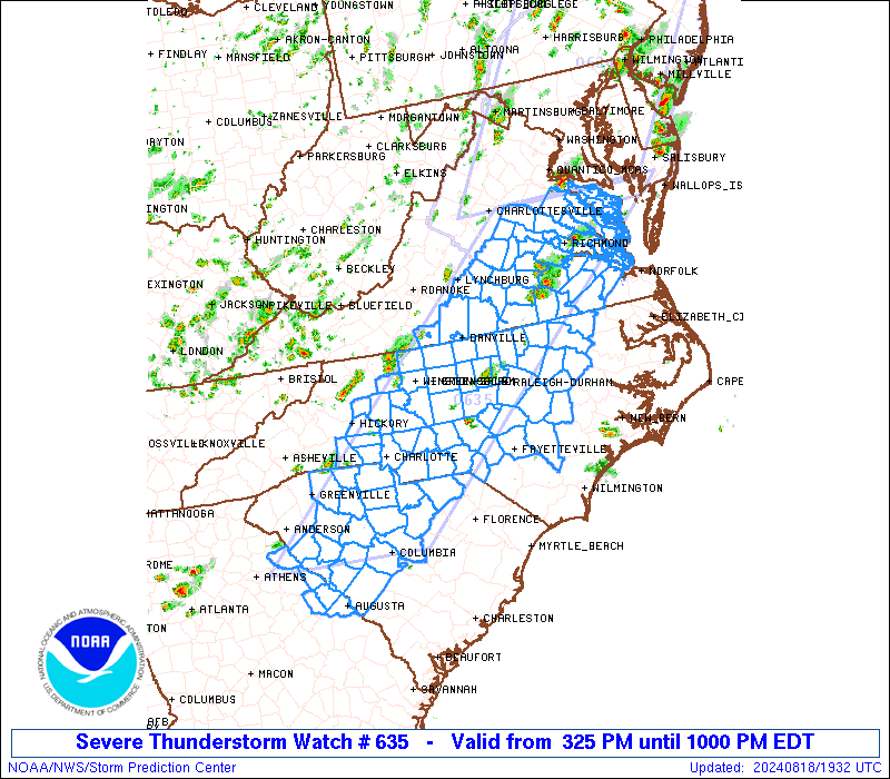
Severe Thunderstorm Watch Number 635
NWS Storm Prediction Center Norman OK
325 PM EDT Sun Aug 18 2024
The NWS Storm Prediction Center has issued a
* Severe Thunderstorm Watch for portions of
Eastern Georgia
Central North Carolina
Central South Carolina
Southern Virginia
Coastal Waters
* Effective this Sunday afternoon and evening from 325 PM until
1000 PM EDT.
* Primary threats include...
Scattered damaging wind gusts to 70 mph possible
Isolated large hail events to 1 inch in diameter possible
SUMMARY...Scattered thunderstorms are forming from central Virginia
into the western Carolinas. These storms will grow in number
through the afternoon, with several strong to severe storms
expected. Damaging winds are the primary threat.
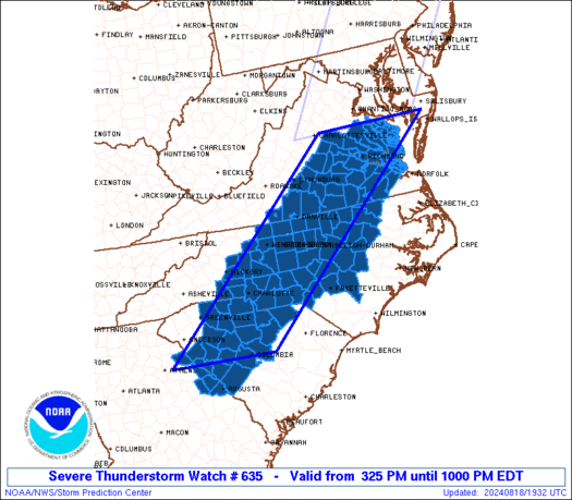
The severe thunderstorm watch area is approximately along and 75
statute miles east and west of a line from 50 miles north northeast
of Richmond VA to 40 miles west of Columbia SC. For a complete
depiction of the watch see the associated watch outline update
(WOUS64 KWNS WOU5).
PRECAUTIONARY/PREPAREDNESS ACTIONS...
REMEMBER...A Severe Thunderstorm Watch means conditions are
favorable for severe thunderstorms in and close to the watch area.
Persons in these areas should be on the lookout for threatening
weather conditions and listen for later statements and possible
warnings. Severe thunderstorms can and occasionally do produce
tornadoes.
&&
OTHER WATCH INFORMATION...CONTINUE...WW 634...
AVIATION...A few severe thunderstorms with hail surface and aloft to
1 inch. Extreme turbulence and surface wind gusts to 60 knots. A few
cumulonimbi with maximum tops to 500. Mean storm motion vector
27025.
...Hart

   SEL5

   URGENT - IMMEDIATE BROADCAST REQUESTED
   Severe Thunderstorm Watch Number 635
   NWS Storm Prediction Center Norman OK
   325 PM EDT Sun Aug 18 2024

   The NWS Storm Prediction Center has issued a

   * Severe Thunderstorm Watch for portions of
     Eastern Georgia
     Central North Carolina
     Central South Carolina
     Southern Virginia
     Coastal Waters

   * Effective this Sunday afternoon and evening from 325 PM until
     1000 PM EDT.

   * Primary threats include...
     Scattered damaging wind gusts to 70 mph possible
     Isolated large hail events to 1 inch in diameter possible

   SUMMARY...Scattered thunderstorms are forming from central Virginia
   into the western Carolinas.  These storms will grow in number
   through the afternoon, with several strong to severe storms
   expected.  Damaging winds are the primary threat.

   The severe thunderstorm watch area is approximately along and 75
   statute miles east and west of a line from 50 miles north northeast
   of Richmond VA to 40 miles west of Columbia SC. For a complete
   depiction of the watch see the associated watch outline update
   (WOUS64 KWNS WOU5).

   PRECAUTIONARY/PREPAREDNESS ACTIONS...

   REMEMBER...A Severe Thunderstorm Watch means conditions are
   favorable for severe thunderstorms in and close to the watch area.
   Persons in these areas should be on the lookout for threatening
   weather conditions and listen for later statements and possible
   warnings. Severe thunderstorms can and occasionally do produce
   tornadoes.

   &&

   OTHER WATCH INFORMATION...CONTINUE...WW 634...

   AVIATION...A few severe thunderstorms with hail surface and aloft to
   1 inch. Extreme turbulence and surface wind gusts to 60 knots. A few
   cumulonimbi with maximum tops to 500. Mean storm motion vector
   27025.

   ...Hart
 Note:
The Aviation Watch (SAW) product is an approximation to the watch area.
The actual watch is depicted by the shaded areas.
Note:
The Aviation Watch (SAW) product is an approximation to the watch area.
The actual watch is depicted by the shaded areas.
   SAW5
   WW 635 SEVERE TSTM GA NC SC VA CW 181925Z - 190200Z
   AXIS..75 STATUTE MILES EAST AND WEST OF LINE..
   50NNE RIC/RICHMOND VA/ - 40W CAE/COLUMBIA SC/
   ..AVIATION COORDS.. 65NM E/W /42S DCA - 22NE IRQ/
   HAIL SURFACE AND ALOFT..1 INCH. WIND GUSTS..60 KNOTS.
   MAX TOPS TO 500. MEAN STORM MOTION VECTOR 27025.

   LAT...LON 38167558 33918051 33918313 38167833

   THIS IS AN APPROXIMATION TO THE WATCH AREA.  FOR A
   COMPLETE DEPICTION OF THE WATCH SEE WOUS64 KWNS
   FOR WOU5.
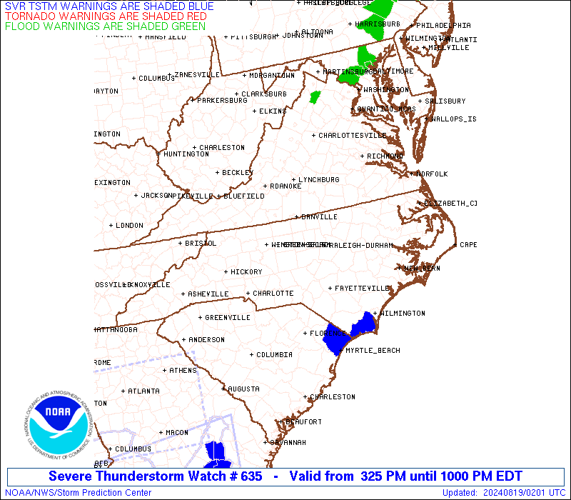
Watch 635 Status Report Messages:
STATUS REPORT #1 ON WW 635

VALID 182140Z - 182240Z

THE SEVERE WEATHER THREAT CONTINUES ACROSS THE ENTIRE WATCH AREA.

..WENDT..08/18/24

ATTN...WFO...CAE...GSP...RAH...RNK...AKQ...

&&

STATUS REPORT FOR WS 635

SEVERE WEATHER THREAT CONTINUES FOR THE FOLLOWING AREAS

GAC073-105-181-189-245-182240-

GA
.    GEORGIA COUNTIES INCLUDED ARE

COLUMBIA	     ELBERT		 LINCOLN
MCDUFFIE	     RICHMOND
$$


NCC001-003-007-025-033-035-037-045-051-057-059-063-065-067-069-
071-077-081-083-085-093-097-101-105-109-119-123-125-127-131-135-
145-151-153-157-159-163-165-167-169-179-181-183-185-191-195-197-
182240-

NC
.    NORTH CAROLINA COUNTIES INCLUDED ARE

ALAMANCE	     ALEXANDER		 ANSON
CABARRUS	     CASWELL		 CATAWBA
CHATHAM 	     CLEVELAND		 CUMBERLAND
DAVIDSON	     DAVIE		 DURHAM
EDGECOMBE	     FORSYTH		 FRANKLIN
GASTON		     GRANVILLE		 GUILFORD
HALIFAX 	     HARNETT		 HOKE
IREDELL 	     JOHNSTON		 LEE
LINCOLN 	     MECKLENBURG	 MONTGOMERY
MOORE		     NASH		 NORTHAMPTON
ORANGE		     PERSON		 RANDOLPH
RICHMOND	     ROCKINGHAM 	 ROWAN
SAMPSON 	     SCOTLAND		 STANLY
STOKES		     UNION		 VANCE
WAKE		     WARREN		 WAYNE
WILSON		     YADKIN
$$


SCC001-003-021-023-025-037-039-047-055-057-059-063-065-071-079-
081-083-087-091-182240-

SC
.    SOUTH CAROLINA COUNTIES INCLUDED ARE

ABBEVILLE	     AIKEN		 CHEROKEE
CHESTER 	     CHESTERFIELD	 EDGEFIELD
FAIRFIELD	     GREENWOOD		 KERSHAW
LANCASTER	     LAURENS		 LEXINGTON
MCCORMICK	     NEWBERRY		 RICHLAND
SALUDA		     SPARTANBURG	 UNION
YORK
$$


VAC007-011-025-029-031-033-036-037-041-049-053-057-065-073-075-
081-083-085-087-089-093-095-097-101-103-109-111-115-117-119-127-
133-135-143-145-147-149-159-175-181-183-193-199-570-590-595-620-
650-670-690-700-730-735-760-830-182240-

VA
.    VIRGINIA COUNTIES INCLUDED ARE

AMELIA		     APPOMATTOX 	 BRUNSWICK
BUCKINGHAM	     CAMPBELL		 CAROLINE
CHARLES CITY	     CHARLOTTE		 CHESTERFIELD
CUMBERLAND	     DINWIDDIE		 ESSEX
FLUVANNA	     GLOUCESTER 	 GOOCHLAND
GREENSVILLE	     HALIFAX		 HANOVER
HENRICO 	     HENRY		 ISLE OF WIGHT
JAMES CITY	     KING AND QUEEN	 KING WILLIAM
LANCASTER	     LOUISA		 LUNENBURG
MATHEWS 	     MECKLENBURG	 MIDDLESEX
NEW KENT	     NORTHUMBERLAND	 NOTTOWAY
PITTSYLVANIA	     POWHATAN		 PRINCE EDWARD
PRINCE GEORGE	     RICHMOND		 SOUTHAMPTON
SURRY		     SUSSEX		 WESTMORELAND
YORK


VIRGINIA INDEPENDENT CITIES INCLUDED ARE

COLONIAL HEIGHTS     DANVILLE		 EMPORIA
FRANKLIN	     HAMPTON		 HOPEWELL
MARTINSVILLE	     NEWPORT NEWS	 PETERSBURG
POQUOSON	     RICHMOND		 WILLIAMSBURG
$$


ANZ635-636-637-182240-

CW

.    ADJACENT COASTAL WATERS INCLUDED ARE

RAPPAHANNOCK RIVER FROM URBANNA TO WINDMILL POINT

YORK RIVER

JAMES RIVER FROM JAMESTOWN TO THE JAMES RIVER BRIDGE

$$
THE WATCH STATUS MESSAGE IS FOR GUIDANCE PURPOSES ONLY.  PLEASE
REFER TO WATCH COUNTY NOTIFICATION STATEMENTS FOR OFFICIAL
INFORMATION ON COUNTIES...INDEPENDENT CITIES AND MARINE ZONES
CLEARED FROM SEVERE THUNDERSTORM AND TORNADO WATCHES.
$$
Note:
Click for Complete Product Text.
Tornadoes
Probability of 2 or more tornadoes
|
Low (10%)
|
Probability of 1 or more strong (EF2-EF5) tornadoes
|
Low (<2%)
|
Wind
Probability of 10 or more severe wind events
|
Mod (50%)
|
Probability of 1 or more wind events > 65 knots
|
Low (20%)
|
Hail
Probability of 10 or more severe hail events
|
Low (20%)
|
Probability of 1 or more hailstones > 2 inches
|
Low (10%)
|
Combined Severe Hail/Wind
Probability of 6 or more combined severe hail/wind events
|
High (70%)
|
For each watch, probabilities for particular events inside the watch
(listed above in each table) are determined by the issuing forecaster.
The "Low" category contains probability values ranging from less than 2%
to 20% (EF2-EF5 tornadoes), less than 5% to 20% (all other probabilities),
"Moderate" from 30% to 60%, and "High" from 70% to greater than 95%.
High values are bolded and lighter in color to provide awareness of
an increased threat for a particular event.


 @NWSSPC