Note:
The expiration time in the watch graphic is amended if the watch is
replaced, cancelled or extended.
Note:
Note:
The expiration time in the watch graphic is amended if the watch is
replaced, cancelled or extended.
Note: Click for
Watch Status Reports.
SEL1
URGENT - IMMEDIATE BROADCAST REQUESTED
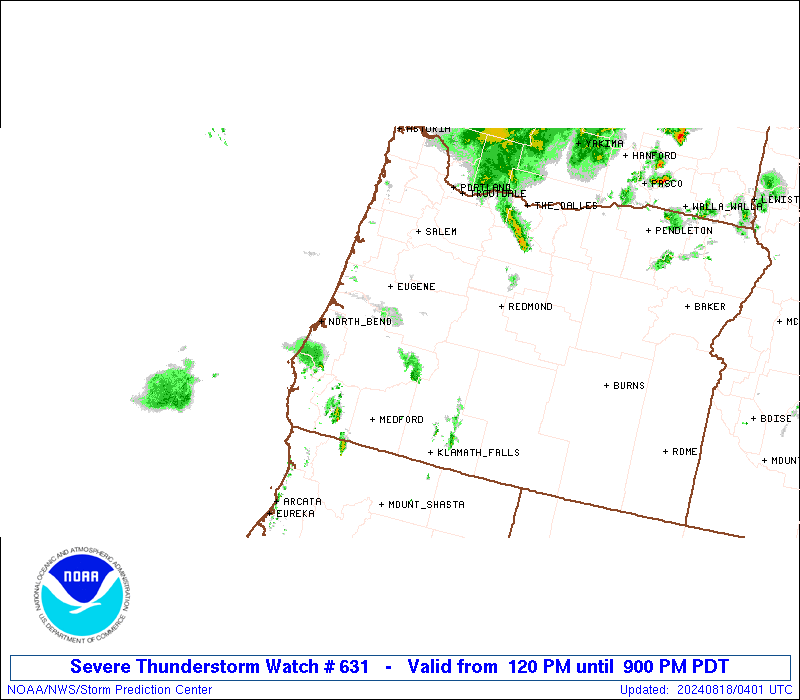
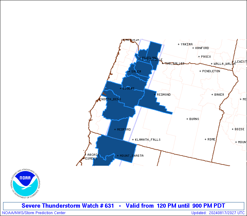
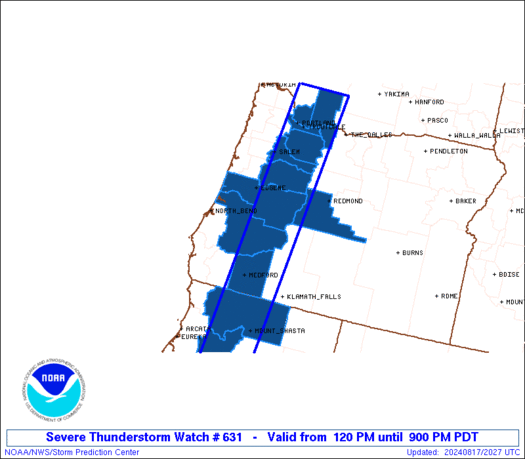
Severe Thunderstorm Watch Number 631
NWS Storm Prediction Center Norman OK
120 PM PDT Sat Aug 17 2024
The NWS Storm Prediction Center has issued a
* Severe Thunderstorm Watch for portions of
Northern California
Western Oregon
Southwest Washington
* Effective this Saturday afternoon and evening from 120 PM until
900 PM PDT.
* Primary threats include...
Scattered damaging wind gusts to 70 mph possible
Scattered large hail events to 1.5 inches in diameter possible
SUMMARY...Thunderstorms will intensify this afternoon along and west
of the Cascade Range, tracking northward across the watch area. A
few severe storms are expected, capable of large hail and locally
damaging wind gusts.
The severe thunderstorm watch area is approximately along and 35
statute miles east and west of a line from 65 miles south southwest
of Mount Shasta CA to 60 miles north northeast of Portland OR. For a
complete depiction of the watch see the associated watch outline
update (WOUS64 KWNS WOU1).
PRECAUTIONARY/PREPAREDNESS ACTIONS...
REMEMBER...A Severe Thunderstorm Watch means conditions are
favorable for severe thunderstorms in and close to the watch area.
Persons in these areas should be on the lookout for threatening
weather conditions and listen for later statements and possible
warnings. Severe thunderstorms can and occasionally do produce
tornadoes.
&&
OTHER WATCH INFORMATION...CONTINUE...WW 630...
AVIATION...A few severe thunderstorms with hail surface and aloft to
1.5 inches. Extreme turbulence and surface wind gusts to 60 knots. A
few cumulonimbi with maximum tops to 500. Mean storm motion vector
20030.
...Hart
   SEL1

   URGENT - IMMEDIATE BROADCAST REQUESTED
   Severe Thunderstorm Watch Number 631
   NWS Storm Prediction Center Norman OK
   120 PM PDT Sat Aug 17 2024

   The NWS Storm Prediction Center has issued a

   * Severe Thunderstorm Watch for portions of
     Northern California
     Western Oregon
     Southwest Washington

   * Effective this Saturday afternoon and evening from 120 PM until
     900 PM PDT.

   * Primary threats include...
     Scattered damaging wind gusts to 70 mph possible
     Scattered large hail events to 1.5 inches in diameter possible

   SUMMARY...Thunderstorms will intensify this afternoon along and west
   of the Cascade Range, tracking northward across the watch area.  A
   few severe storms are expected, capable of large hail and locally
   damaging wind gusts.

   The severe thunderstorm watch area is approximately along and 35
   statute miles east and west of a line from 65 miles south southwest
   of Mount Shasta CA to 60 miles north northeast of Portland OR. For a
   complete depiction of the watch see the associated watch outline
   update (WOUS64 KWNS WOU1).

   PRECAUTIONARY/PREPAREDNESS ACTIONS...

   REMEMBER...A Severe Thunderstorm Watch means conditions are
   favorable for severe thunderstorms in and close to the watch area.
   Persons in these areas should be on the lookout for threatening
   weather conditions and listen for later statements and possible
   warnings. Severe thunderstorms can and occasionally do produce
   tornadoes.

   &&

   OTHER WATCH INFORMATION...CONTINUE...WW 630...

   AVIATION...A few severe thunderstorms with hail surface and aloft to
   1.5 inches. Extreme turbulence and surface wind gusts to 60 knots. A
   few cumulonimbi with maximum tops to 500. Mean storm motion vector
   20030.

   ...Hart
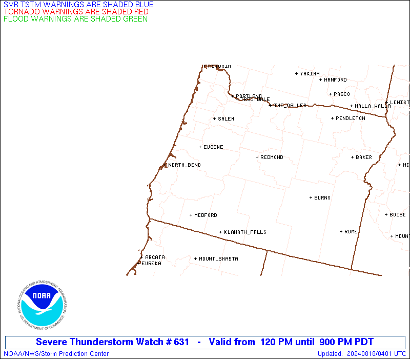
 Note:
The Aviation Watch (SAW) product is an approximation to the watch area.
The actual watch is depicted by the shaded areas.
Note:
The Aviation Watch (SAW) product is an approximation to the watch area.
The actual watch is depicted by the shaded areas.
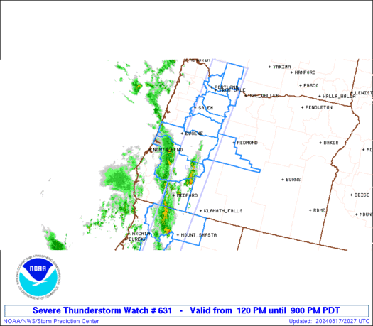
   SAW1
   WW 631 SEVERE TSTM CA OR WA 172020Z - 180400Z
   AXIS..35 STATUTE MILES EAST AND WEST OF LINE..
   65SSW MHS/MOUNT SHASTA CA/ - 60NNE PDX/PORTLAND OR/
   ..AVIATION COORDS.. 30NM E/W /33NW RBL - 43NNE BTG/
   HAIL SURFACE AND ALOFT..1.5 INCHES. WIND GUSTS..60 KNOTS.
   MAX TOPS TO 500. MEAN STORM MOTION VECTOR 20030.

   LAT...LON 40452346 46382285 46382138 40452213

   THIS IS AN APPROXIMATION TO THE WATCH AREA.  FOR A
   COMPLETE DEPICTION OF THE WATCH SEE WOUS64 KWNS
   FOR WOU1.
Watch 631 Status Report Messages:
STATUS REPORT #3 ON WW 631

VALID 180115Z - 180240Z

SEVERE WEATHER THREAT CONTINUES RIGHT OF A LINE FROM 35 NNW RDM
TO 20 SE PDX TO 30 NW PDX.

..SQUITIERI..08/18/24

ATTN...WFO...MFR...EKA...PQR...PDT...

&&

STATUS REPORT FOR WS 631

SEVERE WEATHER THREAT CONTINUES FOR THE FOLLOWING AREAS

ORC017-027-029-180240-

OR
.    OREGON COUNTIES INCLUDED ARE

DESCHUTES	     HOOD RIVER 	 JACKSON
$$


WAC011-059-180240-

WA
.    WASHINGTON COUNTIES INCLUDED ARE

CLARK		     SKAMANIA
$$


THE WATCH STATUS MESSAGE IS FOR GUIDANCE PURPOSES ONLY.  PLEASE
REFER TO WATCH COUNTY NOTIFICATION STATEMENTS FOR OFFICIAL
INFORMATION ON COUNTIES...INDEPENDENT CITIES AND MARINE ZONES
CLEARED FROM SEVERE THUNDERSTORM AND TORNADO WATCHES.
$$

STATUS REPORT #2 ON WW 631

VALID 172230Z - 172340Z

THE SEVERE WEATHER THREAT CONTINUES ACROSS THE ENTIRE WATCH AREA.

..LYONS..08/17/24

ATTN...WFO...MFR...EKA...PQR...PDT...

&&

STATUS REPORT FOR WS 631

SEVERE WEATHER THREAT CONTINUES FOR THE FOLLOWING AREAS

CAC093-105-172340-

CA
.    CALIFORNIA COUNTIES INCLUDED ARE

SISKIYOU	     TRINITY
$$


ORC005-017-019-027-029-039-043-047-051-172340-

OR
.    OREGON COUNTIES INCLUDED ARE

CLACKAMAS	     DESCHUTES		 DOUGLAS
HOOD RIVER	     JACKSON		 LANE
LINN		     MARION		 MULTNOMAH
$$


WAC011-059-172340-

WA
.    WASHINGTON COUNTIES INCLUDED ARE

CLARK		     SKAMANIA
$$


THE WATCH STATUS MESSAGE IS FOR GUIDANCE PURPOSES ONLY.  PLEASE
REFER TO WATCH COUNTY NOTIFICATION STATEMENTS FOR OFFICIAL
INFORMATION ON COUNTIES...INDEPENDENT CITIES AND MARINE ZONES
CLEARED FROM SEVERE THUNDERSTORM AND TORNADO WATCHES.
$$

STATUS REPORT #1 ON WW 631

VALID 172130Z - 172240Z

THE SEVERE WEATHER THREAT CONTINUES ACROSS THE ENTIRE WATCH AREA.

..LYONS..08/17/24

ATTN...WFO...MFR...EKA...PQR...PDT...

&&

STATUS REPORT FOR WS 631

SEVERE WEATHER THREAT CONTINUES FOR THE FOLLOWING AREAS

CAC093-105-172240-

CA
.    CALIFORNIA COUNTIES INCLUDED ARE

SISKIYOU	     TRINITY
$$


ORC005-017-019-027-029-039-043-047-051-172240-

OR
.    OREGON COUNTIES INCLUDED ARE

CLACKAMAS	     DESCHUTES		 DOUGLAS
HOOD RIVER	     JACKSON		 LANE
LINN		     MARION		 MULTNOMAH
$$


WAC011-059-172240-

WA
.    WASHINGTON COUNTIES INCLUDED ARE

CLARK		     SKAMANIA
$$


THE WATCH STATUS MESSAGE IS FOR GUIDANCE PURPOSES ONLY.  PLEASE
REFER TO WATCH COUNTY NOTIFICATION STATEMENTS FOR OFFICIAL
INFORMATION ON COUNTIES...INDEPENDENT CITIES AND MARINE ZONES
CLEARED FROM SEVERE THUNDERSTORM AND TORNADO WATCHES.
$$
Note:
Click for Complete Product Text.
Tornadoes
Probability of 2 or more tornadoes
|
Low (<5%)
|
Probability of 1 or more strong (EF2-EF5) tornadoes
|
Low (<2%)
|
Wind
Probability of 10 or more severe wind events
|
Mod (40%)
|
Probability of 1 or more wind events > 65 knots
|
Low (20%)
|
Hail
Probability of 10 or more severe hail events
|
Mod (40%)
|
Probability of 1 or more hailstones > 2 inches
|
Low (20%)
|
Combined Severe Hail/Wind
Probability of 6 or more combined severe hail/wind events
|
High (70%)
|
For each watch, probabilities for particular events inside the watch
(listed above in each table) are determined by the issuing forecaster.
The "Low" category contains probability values ranging from less than 2%
to 20% (EF2-EF5 tornadoes), less than 5% to 20% (all other probabilities),
"Moderate" from 30% to 60%, and "High" from 70% to greater than 95%.
High values are bolded and lighter in color to provide awareness of
an increased threat for a particular event.


 @NWSSPC