 Note:
The expiration time in the watch graphic is amended if the watch is
replaced, cancelled or extended.
Note:
Note:
The expiration time in the watch graphic is amended if the watch is
replaced, cancelled or extended.
Note: Click for
Watch Status Reports.
SEL4
URGENT - IMMEDIATE BROADCAST REQUESTED
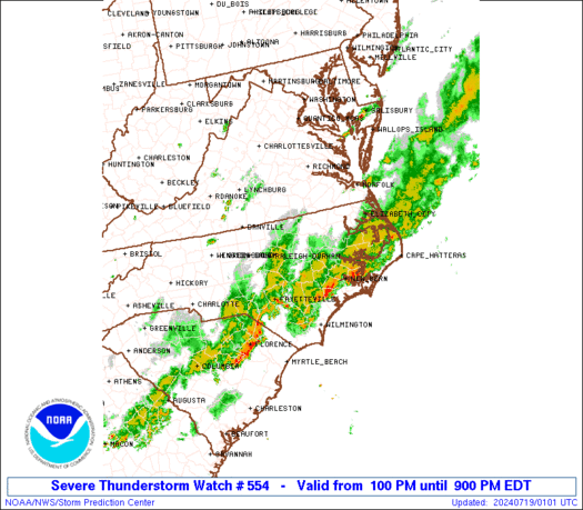
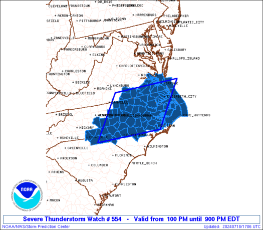
Severe Thunderstorm Watch Number 554
NWS Storm Prediction Center Norman OK
100 PM EDT Thu Jul 18 2024
The NWS Storm Prediction Center has issued a
* Severe Thunderstorm Watch for portions of
Central and Eastern North Carolina
Southeast Virginia
Coastal Waters
* Effective this Thursday afternoon and evening from 100 PM until
900 PM EDT.
* Primary threats include...
Scattered damaging wind gusts to 70 mph likely
Isolated large hail events to 1 inch in diameter possible
SUMMARY...Thunderstorms will continue to intensify across central
North Carolina and central Virginia this afternoon and track
eastward across the watch area. The strongest cells will pose a
risk of locally damaging wind gusts.
The severe thunderstorm watch area is approximately along and 100
statute miles east and west of a line from 15 miles east southeast
of Fayetteville NC to 50 miles northeast of Roanoke Rapids NC. For a
complete depiction of the watch see the associated watch outline
update (WOUS64 KWNS WOU4).
PRECAUTIONARY/PREPAREDNESS ACTIONS...
REMEMBER...A Severe Thunderstorm Watch means conditions are
favorable for severe thunderstorms in and close to the watch area.
Persons in these areas should be on the lookout for threatening
weather conditions and listen for later statements and possible
warnings. Severe thunderstorms can and occasionally do produce
tornadoes.
&&
AVIATION...A few severe thunderstorms with hail surface and aloft to
1 inch. Extreme turbulence and surface wind gusts to 60 knots. A few
cumulonimbi with maximum tops to 500. Mean storm motion vector
28025.
...Hart
 Note:
The Aviation Watch (SAW) product is an approximation to the watch area.
The actual watch is depicted by the shaded areas.
Note:
The Aviation Watch (SAW) product is an approximation to the watch area.
The actual watch is depicted by the shaded areas.
   SAW4
   WW 554 SEVERE TSTM NC VA CW 181700Z - 190100Z
   AXIS..100 STATUTE MILES EAST AND WEST OF LINE..
   15ESE FAY/FAYETTEVILLE NC/ - 50NE RZZ/ROANOKE RAPIDS NC/
   ..AVIATION COORDS.. 85NM E/W /50NW ILM - 35SSE RIC/
   HAIL SURFACE AND ALOFT..1 INCH. WIND GUSTS..60 KNOTS.
   MAX TOPS TO 500. MEAN STORM MOTION VECTOR 28025.

   LAT...LON 34878040 36937887 36937526 34877687

   THIS IS AN APPROXIMATION TO THE WATCH AREA.  FOR A
   COMPLETE DEPICTION OF THE WATCH SEE WOUS64 KWNS
   FOR WOU4.
Watch 554 Status Report Messages:
STATUS REPORT #6 ON WW 554

VALID 182335Z - 190040Z

SEVERE WEATHER THREAT CONTINUES RIGHT OF A LINE FROM 45 WSW SOP
TO 20 WSW RDU TO 25 NW EWN TO 20 SSE ECG.

..GRAMS..07/18/24

ATTN...WFO...RAH...MHX...AKQ...GSP...

&&

STATUS REPORT FOR WS 554

SEVERE WEATHER THREAT CONTINUES FOR THE FOLLOWING AREAS

NCC013-037-049-051-055-061-085-093-095-101-103-105-107-125-137-
153-163-165-177-191-190040-

NC
.    NORTH CAROLINA COUNTIES INCLUDED ARE

BEAUFORT	     CHATHAM		 CRAVEN
CUMBERLAND	     DARE		 DUPLIN
HARNETT 	     HOKE		 HYDE
JOHNSTON	     JONES		 LEE
LENOIR		     MOORE		 PAMLICO
RICHMOND	     SAMPSON		 SCOTLAND
TYRRELL 	     WAYNE
$$


AMZ131-135-136-137-150-152-231-190040-

CW

.    ADJACENT COASTAL WATERS INCLUDED ARE

ALLIGATOR RIVER

PAMLICO SOUND

PAMLICO AND PUNGO RIVERS

NEUSE AND BAY RIVERS

S OF CURRITUCK BEACH LIGHT NC TO OREGON INLET NC OUT TO 20 NM

S OF OREGON INLET NC TO CAPE HATTERAS NC OUT TO 20 NM

CROATAN AND ROANOKE SOUNDS

$$
THE WATCH STATUS MESSAGE IS FOR GUIDANCE PURPOSES ONLY.  PLEASE
REFER TO WATCH COUNTY NOTIFICATION STATEMENTS FOR OFFICIAL
INFORMATION ON COUNTIES...INDEPENDENT CITIES AND MARINE ZONES
CLEARED FROM SEVERE THUNDERSTORM AND TORNADO WATCHES.
$$

STATUS REPORT #5 ON WW 554

VALID 182235Z - 182340Z

SEVERE WEATHER THREAT CONTINUES RIGHT OF A LINE FROM 25 ESE GSO
TO 10 WNW GSB TO 50 N EWN TO 35 ENE ECG.

FOR ADDITIONAL INFORMATION SEE MESOSCALE DISCUSSION 1680.

..GRAMS..07/18/24

ATTN...WFO...RAH...MHX...AKQ...GSP...

&&

STATUS REPORT FOR WS 554

SEVERE WEATHER THREAT CONTINUES FOR THE FOLLOWING AREAS

NCC007-013-037-049-051-055-061-079-085-093-095-101-103-105-107-
123-125-137-147-151-153-163-165-177-179-187-191-182340-

NC
.    NORTH CAROLINA COUNTIES INCLUDED ARE

ANSON		     BEAUFORT		 CHATHAM
CRAVEN		     CUMBERLAND 	 DARE
DUPLIN		     GREENE		 HARNETT
HOKE		     HYDE		 JOHNSTON
JONES		     LEE		 LENOIR
MONTGOMERY	     MOORE		 PAMLICO
PITT		     RANDOLPH		 RICHMOND
SAMPSON 	     SCOTLAND		 TYRRELL
UNION		     WASHINGTON 	 WAYNE
$$


AMZ131-135-136-137-150-152-230-231-ANZ658-182340-

CW

.    ADJACENT COASTAL WATERS INCLUDED ARE

ALLIGATOR RIVER

PAMLICO SOUND

PAMLICO AND PUNGO RIVERS

NEUSE AND BAY RIVERS

S OF CURRITUCK BEACH LIGHT NC TO OREGON INLET NC OUT TO 20 NM

S OF OREGON INLET NC TO CAPE HATTERAS NC OUT TO 20 NM

ALBEMARLE SOUND

CROATAN AND ROANOKE SOUNDS

COASTAL WATERS FROM NC VA BORDER TO CURRITUCK BEACH LIGHT NC OUT
20 NM

$$
THE WATCH STATUS MESSAGE IS FOR GUIDANCE PURPOSES ONLY.  PLEASE
REFER TO WATCH COUNTY NOTIFICATION STATEMENTS FOR OFFICIAL
INFORMATION ON COUNTIES...INDEPENDENT CITIES AND MARINE ZONES
CLEARED FROM SEVERE THUNDERSTORM AND TORNADO WATCHES.
$$

STATUS REPORT #4 ON WW 554

VALID 182135Z - 182240Z

SEVERE WEATHER THREAT CONTINUES RIGHT OF A LINE FROM 20 ESE GSO
TO 30 ESE RWI TO 5 NE ORF.

FOR ADDITIONAL INFORMATION SEE MESOSCALE DISCUSSION 1680.

..GRAMS..07/18/24

ATTN...WFO...RAH...MHX...AKQ...GSP...

&&

STATUS REPORT FOR WS 554

SEVERE WEATHER THREAT CONTINUES FOR THE FOLLOWING AREAS

NCC007-013-015-025-029-037-041-049-051-053-055-057-061-079-085-
093-095-101-103-105-107-117-119-123-125-137-139-143-147-151-153-
163-165-167-177-179-183-187-191-195-182240-

NC
.    NORTH CAROLINA COUNTIES INCLUDED ARE

ANSON		     BEAUFORT		 BERTIE
CABARRUS	     CAMDEN		 CHATHAM
CHOWAN		     CRAVEN		 CUMBERLAND
CURRITUCK	     DARE		 DAVIDSON
DUPLIN		     GREENE		 HARNETT
HOKE		     HYDE		 JOHNSTON
JONES		     LEE		 LENOIR
MARTIN		     MECKLENBURG	 MONTGOMERY
MOORE		     PAMLICO		 PASQUOTANK
PERQUIMANS	     PITT		 RANDOLPH
RICHMOND	     SAMPSON		 SCOTLAND
STANLY		     TYRRELL		 UNION
WAKE		     WASHINGTON 	 WAYNE
WILSON
$$


VAC550-710-740-810-182240-

VA
.    VIRGINIA COUNTIES INCLUDED ARE


VIRGINIA INDEPENDENT CITIES INCLUDED ARE

CHESAPEAKE	     NORFOLK		 PORTSMOUTH
VIRGINIA BEACH
$$


AMZ131-135-136-137-150-152-230-231-ANZ633-634-656-658-182240-

CW

.    ADJACENT COASTAL WATERS INCLUDED ARE

ALLIGATOR RIVER

PAMLICO SOUND

PAMLICO AND PUNGO RIVERS

NEUSE AND BAY RIVERS

S OF CURRITUCK BEACH LIGHT NC TO OREGON INLET NC OUT TO 20 NM

S OF OREGON INLET NC TO CAPE HATTERAS NC OUT TO 20 NM

ALBEMARLE SOUND

CROATAN AND ROANOKE SOUNDS

CURRITUCK SOUND

CHESAPEAKE BAY FROM LITTLE CREEK VA TO CAPE HENRY VA INCLUDING
THE CHESAPEAKE BAY BRIDGE TUNNEL

COASTAL WATERS FROM CAPE CHARLES LIGHT TO VIRGINIA-NORTH CAROLINA
BORDER OUT TO 20 NM

COASTAL WATERS FROM NC VA BORDER TO CURRITUCK BEACH LIGHT NC OUT
20 NM

$$
THE WATCH STATUS MESSAGE IS FOR GUIDANCE PURPOSES ONLY.  PLEASE
REFER TO WATCH COUNTY NOTIFICATION STATEMENTS FOR OFFICIAL
INFORMATION ON COUNTIES...INDEPENDENT CITIES AND MARINE ZONES
CLEARED FROM SEVERE THUNDERSTORM AND TORNADO WATCHES.
$$

STATUS REPORT #3 ON WW 554

VALID 182000Z - 182140Z

SEVERE WEATHER THREAT CONTINUES RIGHT OF A LINE FROM 20 E GSO TO
25 NNW RWI TO 35 SSW RIC.

..HALBERT..07/18/24

ATTN...WFO...RAH...MHX...AKQ...GSP...

&&

STATUS REPORT FOR WS 554

SEVERE WEATHER THREAT CONTINUES FOR THE FOLLOWING AREAS

NCC001-007-013-015-025-029-037-041-049-051-053-055-057-061-063-
065-069-073-079-083-085-091-093-095-101-103-105-107-117-119-123-
125-127-131-135-137-139-143-147-151-153-163-165-167-177-179-183-
187-191-195-182140-

NC
.    NORTH CAROLINA COUNTIES INCLUDED ARE

ALAMANCE	     ANSON		 BEAUFORT
BERTIE		     CABARRUS		 CAMDEN
CHATHAM 	     CHOWAN		 CRAVEN
CUMBERLAND	     CURRITUCK		 DARE
DAVIDSON	     DUPLIN		 DURHAM
EDGECOMBE	     FRANKLIN		 GATES
GREENE		     HALIFAX		 HARNETT
HERTFORD	     HOKE		 HYDE
JOHNSTON	     JONES		 LEE
LENOIR		     MARTIN		 MECKLENBURG
MONTGOMERY	     MOORE		 NASH
NORTHAMPTON	     ORANGE		 PAMLICO
PASQUOTANK	     PERQUIMANS 	 PITT
RANDOLPH	     RICHMOND		 SAMPSON
SCOTLAND	     STANLY		 TYRRELL
UNION		     WAKE		 WASHINGTON
WAYNE		     WILSON
$$


VAC081-093-095-175-181-183-199-550-595-620-650-700-710-735-740-
800-810-830-182140-

VA
.    VIRGINIA COUNTIES INCLUDED ARE

GREENSVILLE	     ISLE OF WIGHT	 JAMES CITY
SOUTHAMPTON	     SURRY		 SUSSEX
YORK


VIRGINIA INDEPENDENT CITIES INCLUDED ARE

CHESAPEAKE	     EMPORIA		 FRANKLIN
HAMPTON 	     NEWPORT NEWS	 NORFOLK
POQUOSON	     PORTSMOUTH 	 SUFFOLK
VIRGINIA BEACH	     WILLIAMSBURG
$$


AMZ131-135-136-137-150-152-230-231-ANZ632-633-634-637-638-656-658-
182140-

CW

.    ADJACENT COASTAL WATERS INCLUDED ARE

ALLIGATOR RIVER

PAMLICO SOUND

PAMLICO AND PUNGO RIVERS

NEUSE AND BAY RIVERS

S OF CURRITUCK BEACH LIGHT NC TO OREGON INLET NC OUT TO 20 NM

S OF OREGON INLET NC TO CAPE HATTERAS NC OUT TO 20 NM

ALBEMARLE SOUND

CROATAN AND ROANOKE SOUNDS

CHESAPEAKE BAY FROM NEW POINT COMFORT TO LITTLE CREEK VA

CURRITUCK SOUND

CHESAPEAKE BAY FROM LITTLE CREEK VA TO CAPE HENRY VA INCLUDING
THE CHESAPEAKE BAY BRIDGE TUNNEL

JAMES RIVER FROM JAMESTOWN TO THE JAMES RIVER BRIDGE

JAMES RIVER FROM JAMES RIVER BRIDGE TO HAMPTON ROADS
BRIDGE-TUNNEL

COASTAL WATERS FROM CAPE CHARLES LIGHT TO VIRGINIA-NORTH CAROLINA
BORDER OUT TO 20 NM

COASTAL WATERS FROM NC VA BORDER TO CURRITUCK BEACH LIGHT NC OUT
20 NM

$$
THE WATCH STATUS MESSAGE IS FOR GUIDANCE PURPOSES ONLY.  PLEASE
REFER TO WATCH COUNTY NOTIFICATION STATEMENTS FOR OFFICIAL
INFORMATION ON COUNTIES...INDEPENDENT CITIES AND MARINE ZONES
CLEARED FROM SEVERE THUNDERSTORM AND TORNADO WATCHES.
$$

STATUS REPORT #2 ON WW 554

VALID 181915Z - 182040Z

THE SEVERE WEATHER THREAT CONTINUES ACROSS THE ENTIRE WATCH AREA.

..HALBERT..07/18/24

ATTN...WFO...RAH...MHX...AKQ...GSP...

&&

STATUS REPORT FOR WS 554

SEVERE WEATHER THREAT CONTINUES FOR THE FOLLOWING AREAS

NCC001-007-013-015-025-029-037-041-049-051-053-055-057-061-063-
065-069-073-077-079-083-085-091-093-095-101-103-105-107-117-119-
123-125-127-131-135-137-139-143-145-147-151-153-163-165-167-177-
179-181-183-185-187-191-195-182040-

NC
.    NORTH CAROLINA COUNTIES INCLUDED ARE

ALAMANCE	     ANSON		 BEAUFORT
BERTIE		     CABARRUS		 CAMDEN
CHATHAM 	     CHOWAN		 CRAVEN
CUMBERLAND	     CURRITUCK		 DARE
DAVIDSON	     DUPLIN		 DURHAM
EDGECOMBE	     FRANKLIN		 GATES
GRANVILLE	     GREENE		 HALIFAX
HARNETT 	     HERTFORD		 HOKE
HYDE		     JOHNSTON		 JONES
LEE		     LENOIR		 MARTIN
MECKLENBURG	     MONTGOMERY 	 MOORE
NASH		     NORTHAMPTON	 ORANGE
PAMLICO 	     PASQUOTANK 	 PERQUIMANS
PERSON		     PITT		 RANDOLPH
RICHMOND	     SAMPSON		 SCOTLAND
STANLY		     TYRRELL		 UNION
VANCE		     WAKE		 WARREN
WASHINGTON	     WAYNE		 WILSON
$$


VAC025-081-093-095-111-117-175-181-183-199-550-595-620-650-700-
710-735-740-800-810-830-182040-

VA
.    VIRGINIA COUNTIES INCLUDED ARE

BRUNSWICK	     GREENSVILLE	 ISLE OF WIGHT
JAMES CITY	     LUNENBURG		 MECKLENBURG
SOUTHAMPTON	     SURRY		 SUSSEX
YORK


VIRGINIA INDEPENDENT CITIES INCLUDED ARE

CHESAPEAKE	     EMPORIA		 FRANKLIN
HAMPTON 	     NEWPORT NEWS	 NORFOLK
POQUOSON	     PORTSMOUTH 	 SUFFOLK
VIRGINIA BEACH	     WILLIAMSBURG
$$


AMZ131-135-136-137-150-152-230-231-ANZ632-633-634-637-638-656-658-
182040-

CW

.    ADJACENT COASTAL WATERS INCLUDED ARE

ALLIGATOR RIVER

PAMLICO SOUND

PAMLICO AND PUNGO RIVERS

NEUSE AND BAY RIVERS

S OF CURRITUCK BEACH LIGHT NC TO OREGON INLET NC OUT TO 20 NM

S OF OREGON INLET NC TO CAPE HATTERAS NC OUT TO 20 NM

ALBEMARLE SOUND

CROATAN AND ROANOKE SOUNDS

CHESAPEAKE BAY FROM NEW POINT COMFORT TO LITTLE CREEK VA

CURRITUCK SOUND

CHESAPEAKE BAY FROM LITTLE CREEK VA TO CAPE HENRY VA INCLUDING
THE CHESAPEAKE BAY BRIDGE TUNNEL

JAMES RIVER FROM JAMESTOWN TO THE JAMES RIVER BRIDGE

JAMES RIVER FROM JAMES RIVER BRIDGE TO HAMPTON ROADS
BRIDGE-TUNNEL

COASTAL WATERS FROM CAPE CHARLES LIGHT TO VIRGINIA-NORTH CAROLINA
BORDER OUT TO 20 NM

COASTAL WATERS FROM NC VA BORDER TO CURRITUCK BEACH LIGHT NC OUT
20 NM

$$
THE WATCH STATUS MESSAGE IS FOR GUIDANCE PURPOSES ONLY.  PLEASE
REFER TO WATCH COUNTY NOTIFICATION STATEMENTS FOR OFFICIAL
INFORMATION ON COUNTIES...INDEPENDENT CITIES AND MARINE ZONES
CLEARED FROM SEVERE THUNDERSTORM AND TORNADO WATCHES.
$$

STATUS REPORT #1 ON WW 554

VALID 181810Z - 181940Z

THE SEVERE WEATHER THREAT CONTINUES ACROSS THE ENTIRE WATCH AREA.

..HALBERT..07/18/24

ATTN...WFO...RAH...MHX...AKQ...GSP...

&&

STATUS REPORT FOR WS 554

SEVERE WEATHER THREAT CONTINUES FOR THE FOLLOWING AREAS

NCC001-007-013-015-025-029-037-041-049-051-053-055-057-061-063-
065-069-073-077-079-083-085-091-093-095-101-103-105-107-117-119-
123-125-127-131-135-137-139-143-145-147-151-153-163-165-167-177-
179-181-183-185-187-191-195-181940-

NC
.    NORTH CAROLINA COUNTIES INCLUDED ARE

ALAMANCE	     ANSON		 BEAUFORT
BERTIE		     CABARRUS		 CAMDEN
CHATHAM 	     CHOWAN		 CRAVEN
CUMBERLAND	     CURRITUCK		 DARE
DAVIDSON	     DUPLIN		 DURHAM
EDGECOMBE	     FRANKLIN		 GATES
GRANVILLE	     GREENE		 HALIFAX
HARNETT 	     HERTFORD		 HOKE
HYDE		     JOHNSTON		 JONES
LEE		     LENOIR		 MARTIN
MECKLENBURG	     MONTGOMERY 	 MOORE
NASH		     NORTHAMPTON	 ORANGE
PAMLICO 	     PASQUOTANK 	 PERQUIMANS
PERSON		     PITT		 RANDOLPH
RICHMOND	     SAMPSON		 SCOTLAND
STANLY		     TYRRELL		 UNION
VANCE		     WAKE		 WARREN
WASHINGTON	     WAYNE		 WILSON
$$


VAC025-081-093-095-111-117-175-181-183-199-550-595-620-650-700-
710-735-740-800-810-830-181940-

VA
.    VIRGINIA COUNTIES INCLUDED ARE

BRUNSWICK	     GREENSVILLE	 ISLE OF WIGHT
JAMES CITY	     LUNENBURG		 MECKLENBURG
SOUTHAMPTON	     SURRY		 SUSSEX
YORK


VIRGINIA INDEPENDENT CITIES INCLUDED ARE

CHESAPEAKE	     EMPORIA		 FRANKLIN
HAMPTON 	     NEWPORT NEWS	 NORFOLK
POQUOSON	     PORTSMOUTH 	 SUFFOLK
VIRGINIA BEACH	     WILLIAMSBURG
$$


AMZ131-135-136-137-150-152-230-231-ANZ632-633-634-637-638-656-658-
181940-

CW

.    ADJACENT COASTAL WATERS INCLUDED ARE

ALLIGATOR RIVER

PAMLICO SOUND

PAMLICO AND PUNGO RIVERS

NEUSE AND BAY RIVERS

S OF CURRITUCK BEACH LIGHT NC TO OREGON INLET NC OUT TO 20 NM

S OF OREGON INLET NC TO CAPE HATTERAS NC OUT TO 20 NM

ALBEMARLE SOUND

CROATAN AND ROANOKE SOUNDS

CHESAPEAKE BAY FROM NEW POINT COMFORT TO LITTLE CREEK VA

CURRITUCK SOUND

CHESAPEAKE BAY FROM LITTLE CREEK VA TO CAPE HENRY VA INCLUDING
THE CHESAPEAKE BAY BRIDGE TUNNEL

JAMES RIVER FROM JAMESTOWN TO THE JAMES RIVER BRIDGE

JAMES RIVER FROM JAMES RIVER BRIDGE TO HAMPTON ROADS
BRIDGE-TUNNEL

COASTAL WATERS FROM CAPE CHARLES LIGHT TO VIRGINIA-NORTH CAROLINA
BORDER OUT TO 20 NM

COASTAL WATERS FROM NC VA BORDER TO CURRITUCK BEACH LIGHT NC OUT
20 NM

$$
THE WATCH STATUS MESSAGE IS FOR GUIDANCE PURPOSES ONLY.  PLEASE
REFER TO WATCH COUNTY NOTIFICATION STATEMENTS FOR OFFICIAL
INFORMATION ON COUNTIES...INDEPENDENT CITIES AND MARINE ZONES
CLEARED FROM SEVERE THUNDERSTORM AND TORNADO WATCHES.
$$
Note:
Click for Complete Product Text.
Tornadoes
Probability of 2 or more tornadoes
|
Low (<5%)
|
Probability of 1 or more strong (EF2-EF5) tornadoes
|
Low (<2%)
|
Wind
Probability of 10 or more severe wind events
|
Mod (60%)
|
Probability of 1 or more wind events > 65 knots
|
Low (20%)
|
Hail
Probability of 10 or more severe hail events
|
Low (20%)
|
Probability of 1 or more hailstones > 2 inches
|
Low (10%)
|
Combined Severe Hail/Wind
Probability of 6 or more combined severe hail/wind events
|
High (80%)
|
For each watch, probabilities for particular events inside the watch
(listed above in each table) are determined by the issuing forecaster.
The "Low" category contains probability values ranging from less than 2%
to 20% (EF2-EF5 tornadoes), less than 5% to 20% (all other probabilities),
"Moderate" from 30% to 60%, and "High" from 70% to greater than 95%.
High values are bolded and lighter in color to provide awareness of
an increased threat for a particular event.


 @NWSSPC


