|
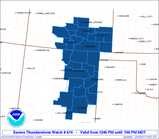
Initial List of Counties in SPC Severe Thunderstorm Watch 674 (WOU)
|
Back to Watch 674
|
 |
   WOUS64 KWNS 171844
   WOU4

   BULLETIN - IMMEDIATE BROADCAST REQUESTED
   SEVERE THUNDERSTORM WATCH OUTLINE UPDATE FOR WS 674
   NWS STORM PREDICTION CENTER NORMAN OK
   1245 PM MDT TUE SEP 17 2024

   SEVERE THUNDERSTORM WATCH 674 IS IN EFFECT UNTIL 700 PM MDT
   FOR THE FOLLOWING LOCATIONS

   COC003-009-011-021-023-025-027-041-043-055-061-071-089-099-101-
   109-119-180100-
   /O.NEW.KWNS.SV.A.0674.240917T1845Z-240918T0100Z/

   CO
   .    COLORADO COUNTIES INCLUDED ARE

   ALAMOSA              BACA                BENT
   CONEJOS              COSTILLA            CROWLEY
   CUSTER               EL PASO             FREMONT
   HUERFANO             KIOWA               LAS ANIMAS
   OTERO                PROWERS             PUEBLO
   SAGUACHE             TELLER


   NMC005-007-009-011-019-021-027-033-037-041-047-055-059-180100-
   /O.NEW.KWNS.SV.A.0674.240917T1845Z-240918T0100Z/

   NM
   .    NEW MEXICO COUNTIES INCLUDED ARE

   CHAVES               COLFAX              CURRY
   DE BACA              GUADALUPE           HARDING
   LINCOLN              MORA                QUAY
   ROOSEVELT            SAN MIGUEL          TAOS
   UNION


   ATTN...WFO...PUB...ABQ...
|
| Aviation Watch (SAW) for WW674 |
|---|
 |
| Note:
The Aviation Watch (SAW) product is an approximation to the watch area.
The actual watch is depicted by the shaded areas. |
   SAW4
   WW 674 SEVERE TSTM CO NM 171845Z - 180100Z
   AXIS..60 STATUTE MILES EAST AND WEST OF LINE..
   35ENE PUB/PUEBLO CO/ - 5SW ROW/ROSWELL NM/
   ..AVIATION COORDS.. 50NM E/W /27ENE PUB - 6SSE CME/
   HAIL SURFACE AND ALOFT..1.5 INCHES. WIND GUSTS..65 KNOTS.
   MAX TOPS TO 500. MEAN STORM MOTION VECTOR 24040.

   LAT...LON 38470279 33230355 33230563 38470501

   THIS IS AN APPROXIMATION TO THE WATCH AREA.  FOR A
   COMPLETE DEPICTION OF THE WATCH SEE WOUS64 KWNS
   FOR WOU4.
|
|


 @NWSSPC
