|
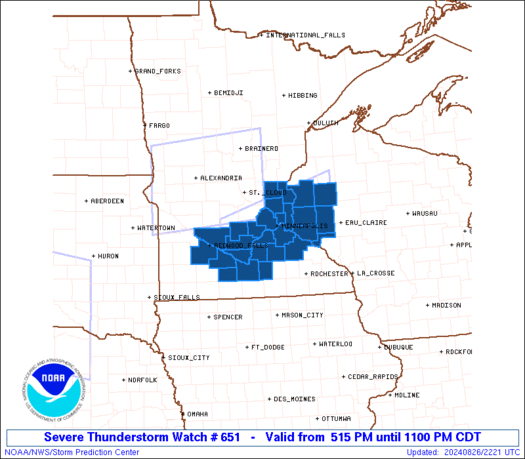
Initial List of Counties in SPC Severe Thunderstorm Watch 651 (WOU)
|
Back to Watch 651
|
 |
   WOUS64 KWNS 262214
   WOU1

   BULLETIN - IMMEDIATE BROADCAST REQUESTED
   SEVERE THUNDERSTORM WATCH OUTLINE UPDATE FOR WS 651
   NWS STORM PREDICTION CENTER NORMAN OK
   515 PM CDT MON AUG 26 2024

   SEVERE THUNDERSTORM WATCH 651 IS IN EFFECT UNTIL 1100 PM CDT
   FOR THE FOLLOWING LOCATIONS

   MNC003-013-015-019-025-037-049-053-059-079-085-103-123-127-129-
   131-139-143-161-163-165-270400-
   /O.NEW.KWNS.SV.A.0651.240826T2215Z-240827T0400Z/

   MN
   .    MINNESOTA COUNTIES INCLUDED ARE

   ANOKA                BLUE EARTH          BROWN
   CARVER               CHISAGO             DAKOTA
   GOODHUE              HENNEPIN            ISANTI
   LE SUEUR             MCLEOD              NICOLLET
   RAMSEY               REDWOOD             RENVILLE
   RICE                 SCOTT               SIBLEY
   WASECA               WASHINGTON          WATONWAN


   WIC005-033-091-093-095-109-270400-
   /O.NEW.KWNS.SV.A.0651.240826T2215Z-240827T0400Z/

   WI
   .    WISCONSIN COUNTIES INCLUDED ARE

   BARRON               DUNN                PEPIN
   PIERCE               POLK                ST. CROIX


   ATTN...WFO...MPX...
|
| Aviation Watch (SAW) for WW651 |
|---|
 |
| Note:
The Aviation Watch (SAW) product is an approximation to the watch area.
The actual watch is depicted by the shaded areas. |
   SAW1
   WW 651 SEVERE TSTM MN WI 262215Z - 270400Z
   AXIS..40 STATUTE MILES NORTH AND SOUTH OF LINE..
   45WNW MKT/MANKATO MN/ - 80ENE MSP/MINNEAPOLIS MN/
   ..AVIATION COORDS.. 35NM N/S /16E RWF - 26NNW EAU/
   HAIL SURFACE AND ALOFT..2 INCHES. WIND GUSTS..65 KNOTS.
   MAX TOPS TO 500. MEAN STORM MOTION VECTOR 28025.

   LAT...LON 45059476 45899170 44739170 43899476

   THIS IS AN APPROXIMATION TO THE WATCH AREA.  FOR A
   COMPLETE DEPICTION OF THE WATCH SEE WOUS64 KWNS
   FOR WOU1.
|
|


 @NWSSPC
