|
| Mesoscale Discussion 2252 |
|
< Previous MD Next MD >
|

|
   Mesoscale Discussion 2252
   NWS Storm Prediction Center Norman OK
   0859 PM CST Sun Dec 08 2024

   Areas affected...Eastern Montana and far western North Dakota

   Concerning...Blizzard

   Valid 090259Z - 090900Z

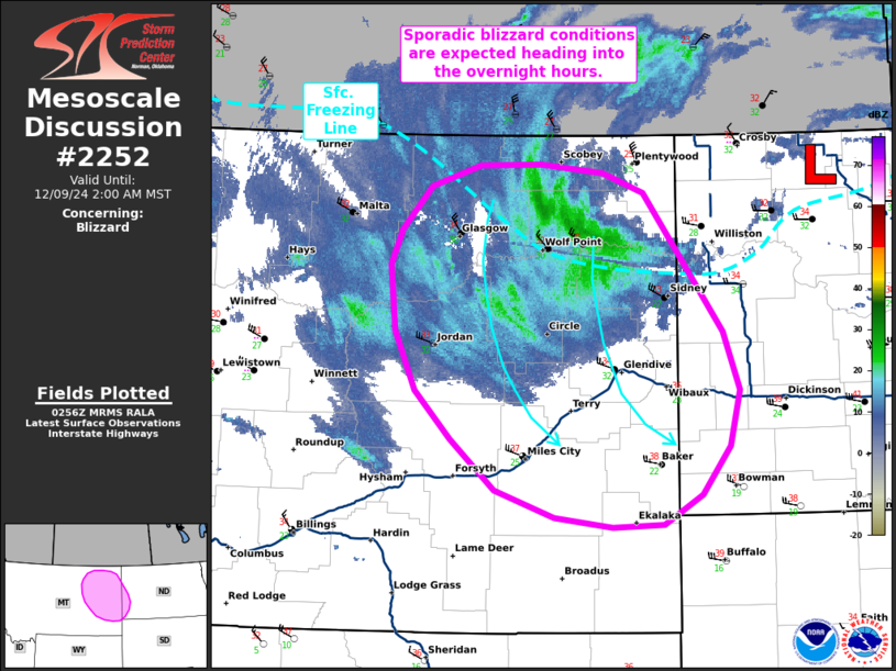
   SUMMARY...Sporadic blizzard conditions are likely through the
   overnight hours across eastern Montana and into far western North
   Dakota. Conditions are expected to deteriorate steadily between
   06-12 UTC as light to moderate snow fall rates coincide with 30-35
   mph winds.

   DISCUSSION...Temperatures across eastern MT have been steadily
   falling to below freezing as a cold front begins to push south into
   the northern Plains. This has been promoting a change over from a
   wintry mix to predominantly snow, which is expected to gradually
   spread southeast through early Monday morning as a surface low
   translates east along the international border. Sustained gradient
   winds between 30-35 mph are being observed with gusts upwards of
   40-45 mph. Blowing snow model output suggests that with light to
   moderate snow fall rates (0.25-0.5 in/hour) and temperatures in the
   low 30s, these sustained winds will result in sporadic/transient
   blizzard conditions with more significant/widespread visibility
   reductions likely where gusts exceed 40 mph. Early indications of
   this trend have already been noted across northeast MT where
   periodic visibility reductions down to 1/2 mile have been coincident
   with gusts over 40 mph. Such conditions should become more common
   across eastern MT/far western ND as the surface freezing line pushes
   south and supports snow as the primary precipitation type. Recent
   HRRR solutions suggest sporadic blizzard conditions will begin to
   impact the I-94 corridor as early as 05-06 UTC.

   ..Moore.. 12/09/2024

   ...Please see www.spc.noaa.gov for graphic product...

   ATTN...WFO...BIS...BYZ...GGW...

   LAT...LON   48760638 48770564 48700492 48540444 47410350 46950331
               46500343 46100377 45860421 45840482 45930550 46150620
               46550671 46950713 47420737 47950743 48230730 48590696
               48760638
|
|
Top/All Mesoscale Discussions/Forecast Products/Home
|
|


