|
| Mesoscale Discussion 2251 |
|
< Previous MD Next MD >
|

|
   Mesoscale Discussion 2251
   NWS Storm Prediction Center Norman OK
   0214 PM CST Fri Dec 06 2024

   Areas affected...portions of western New York

   Concerning...Heavy snow

   Valid 062014Z - 070115Z

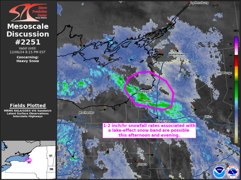
   SUMMARY...Lake-effect snow rates approaching 2 inches an hour are
   possible into the evening hours.

   DISCUSSION...A lake-effect snow band is ongoing across portions of
   Lake Ontario, which is impinging on Oswego County NY and is
   producing heavy snow based on the Fulton/Oswego County Airport ASOS.
   Some slight backing of the low-level winds from northwesterly to
   westerly, as shown by surface observations, will support a longer
   fetch of moisture across Lake Ontario. These backing winds may help
   intensify the ongoing snow band, as well as encourage this band to
   take on a slightly more west-to-east orientation over the next
   several hours. While at least one inch/hr rates are likely in the
   immediate term, snowfall rates approaching 2 inches/hr may be
   possible later this afternoon and evening.

   ..Squitieri.. 12/06/2024

   ...Please see www.spc.noaa.gov for graphic product...

   ATTN...WFO...BGM...BUF...

   LAT...LON   43517674 43677667 43747647 43757625 43637594 43467581
               43407581 43277585 43227599 43277632 43317654 43517674
|
|
Top/All Mesoscale Discussions/Forecast Products/Home
|
|


