|
| Mesoscale Discussion 222 |
|
< Previous MD Next MD >
|
|
Mesoscale Discussion 0222
NWS Storm Prediction Center Norman OK
0628 AM CDT Sun Mar 16 2025
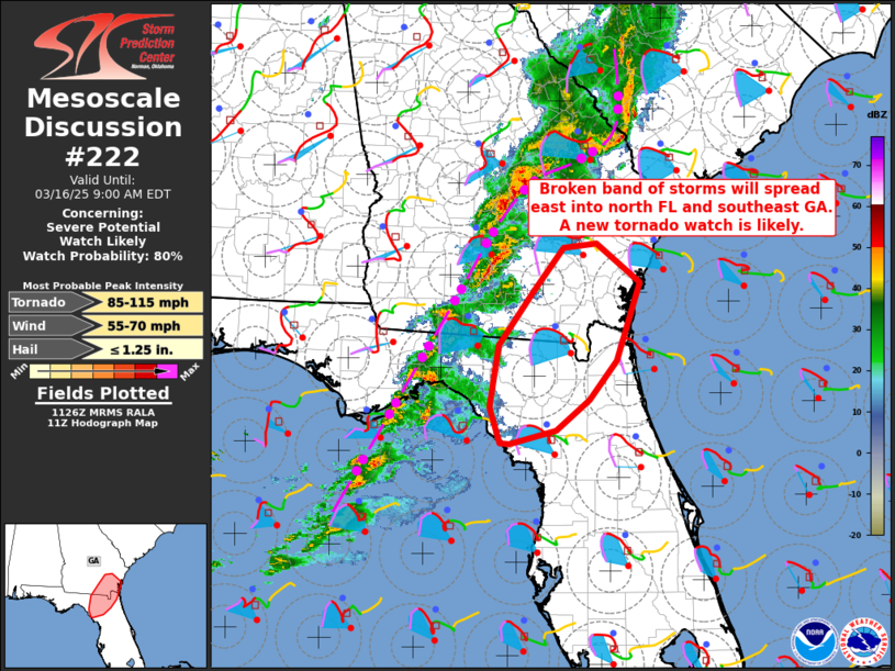
Areas affected...North Florida and southeast Georgia
Concerning...Severe potential...Watch likely
Valid 161128Z - 161300Z
Probability of Watch Issuance...80 percent
SUMMARY...A broken band of storms will spread eastward into
southeast Georgia and north Florida through late morning. A new
tornado watch appears likely.
DISCUSSION...A broken band of storms has persisted overnight from
south central GA into the eastern FL Panhandle, with
occasional/embedded supercell structures. Low-level moistening over
the next few hours and the onset of diurnal heating will drive
destabilization across north FL/southeast GA later this morning.
Though the low-level jet core will develop northeastward toward the
Carolinas through the day, low-level flow/shear will remain
sufficiently strong to support additional supercells through the
morning across north FL/southeast GA. The storms will remain
capable of producing occasional damaging winds and possibly a couple
of tornadoes, and a new tornado watch will likely be needed from
12-13z.
..Thompson/Smith.. 03/16/2025
...Please see www.spc.noaa.gov for graphic product...
ATTN...WFO...CHS...TBW...JAX...TAE...
LAT...LON 31288133 30368164 29908202 29548247 29388309 29388323
29808337 30538324 31158280 31698236 31748192 31288133
|
|
Top/All Mesoscale Discussions/Forecast Products/Home
|
|


 @NWSSPC