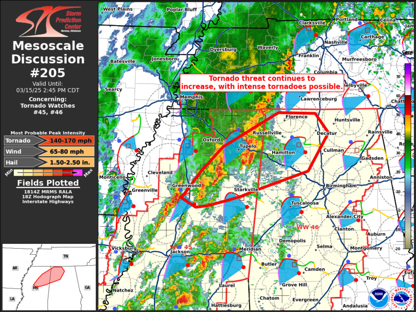
   Mesoscale Discussion 0205
   NWS Storm Prediction Center Norman OK
   0116 PM CDT Sat Mar 15 2025

   Areas affected...portions of northern Mississippi into northwestern
   Alabama

   Concerning...Tornado Watch 45...46...

   Valid 151816Z - 151945Z

   The severe weather threat for Tornado Watch 45, 46 continues.

   SUMMARY...The risk for tornadoes continues across northern MS into
   northwestern AL, particularly with a supercell in Montgomery County.
   Intense tornadoes (EF3+) are possible.

   DISCUSSION...A QLCS has evolved into more discrete supercells, some
   of which have become dominant relative to other convective elements
   in the area. Some of these storms have a history of tornadoes, and a
   supercell in Montgomery County, MS has a persistent mesocyclone that
   continues to intensify per KDGX and KGWX NEXRAD data. The GWX VAD
   shows an impressively large and curved hodograph, with nearly 500
   m2/s2 effective SRH in just the surface-500 m layer, with about 1000
   m2/s2 SRH in the sfc-3 km layer. As such, the ambient environment
   supports intense tornadoes (EF3+). However, this is contingent on
   storms benefiting from minimal interference by other nearby storms,
   including the absorption of smaller storms. If one of the more
   dominant storms (especially the Montgomery County storm) can obtain
   a pristine inflow environment, the chance for intense tornado
   development is high. Damaging gusts are possible, especially with
   any linear segments that materialize.

   ..Squitieri.. 03/15/2025

   ...Please see www.spc.noaa.gov for graphic product...

   ATTN...WFO...BMX...HUN...MEG...JAN...

   LAT...LON   33368995 33878950 34318904 34948780 34928698 34568670
               33858716 33488837 33408862 33318894 33228937 33198963
               33368995
|


 @NWSSPC