|
| Mesoscale Discussion 193 |
|
< Previous MD Next MD >
|
|
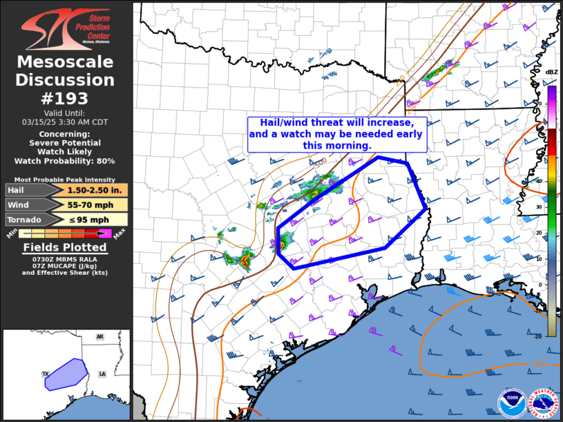
   Mesoscale Discussion 0193
   NWS Storm Prediction Center Norman OK
   0232 AM CDT Sat Mar 15 2025

   Areas affected...Parts of southeast and east central Texas

   Concerning...Severe potential...Watch likely

   Valid 150732Z - 150830Z

   Probability of Watch Issuance...80 percent

   SUMMARY...Thunderstorms will likely increase in coverage/intensity
   the next few hours, with an increasing threat for large hail and
   wind damage.  A severe thunderstorm watch may be needed by 08z.

   DISCUSSION...The leading edge of ascent in the left-exit region of
   an upper jet streak is impinging on a slow-moving cold front and the
   northwest edge of the richer low-level moisture across southeast TX.
   Steep midlevel lapse rates and strong deep-layer shear will favor
   organized/supercell storms as convection increases through the early
   morning, with large hail and damaging gusts the primary threats.  A
   new severe thunderstorm watch is likely in the next hour.

   ..Thompson/Smith.. 03/15/2025

   ...Please see www.spc.noaa.gov for graphic product...

   ATTN...WFO...LCH...SHV...HGX...FWD...EWX...

   LAT...LON   31179363 30469451 30069645 30349678 30829680 31349603
               32159465 32039401 31179363
|
|
Top/All Mesoscale Discussions/Forecast Products/Home
|
|


 @NWSSPC