|
| Mesoscale Discussion 184 |
|
< Previous MD Next MD >
|
|
Mesoscale Discussion 0184
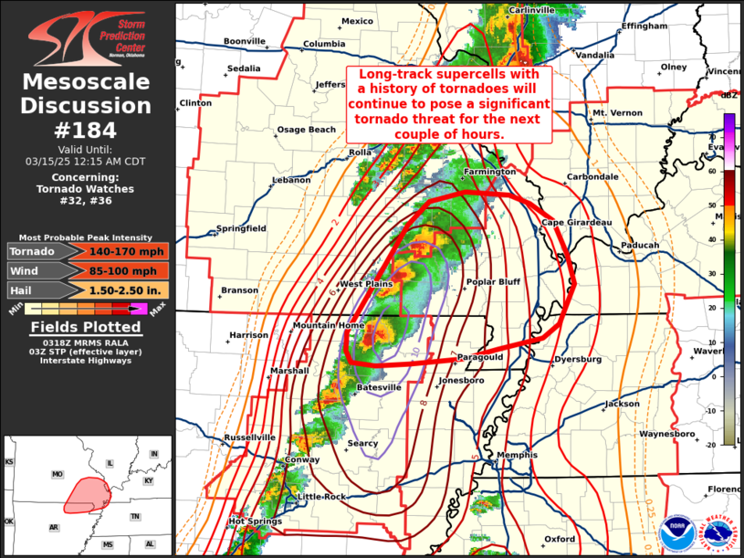
NWS Storm Prediction Center Norman OK
1020 PM CDT Fri Mar 14 2025
Areas affected...Northeast Arkansas into the Missouri Bootheel
Concerning...Tornado Watch 32...36...
Valid 150320Z - 150515Z
The severe weather threat for Tornado Watch 32, 36 continues.
SUMMARY...Supercells with a history of producing tornadoes will
continue to pose a tornado threat (including significant tornadoes)
for the next couple of hours as they move into northeast Arkansas
and southeast Missouri.
DISCUSSION...Two long-lived supercells moving across north-central
AR and south-central MO have had a history of producing tornadoes
per dual-pol data and spotter reports. Based on rotational velocity
estimates and the magnitude of the convective environment
(characterized by STP values up to 10), one or more of these
tornadoes were likely significant (EF-2+). These cells will continue
to reside in this exceptionally rare STP environment for the next
1-2 hours as they move into far northeast AR and southeast MO.
Consequently, the potential for additional long-track and
significant (possibly intense) tornadoes will continue across this
region.
..Moore.. 03/15/2025
...Please see www.spc.noaa.gov for graphic product...
ATTN...WFO...PAH...MEG...LSX...LZK...SGF...
LAT...LON 36288949 36199000 36109040 36059102 36039140 36059169
36169174 36349174 37349105 37569080 37659037 37618987
37538962 37378936 37068920 36788911 36428929 36288949
|
|
Top/All Mesoscale Discussions/Forecast Products/Home
|
|


 @NWSSPC