|
| Mesoscale Discussion 180 |
|
< Previous MD Next MD >
|

|
   Mesoscale Discussion 0180
   NWS Storm Prediction Center Norman OK
   0843 PM CDT Fri Mar 14 2025

   Areas affected...Central Arkansas into far south-central Missouri

   Concerning...Tornado Watch 32...

   Valid 150143Z - 150345Z

   The severe weather threat for Tornado Watch 32 continues.

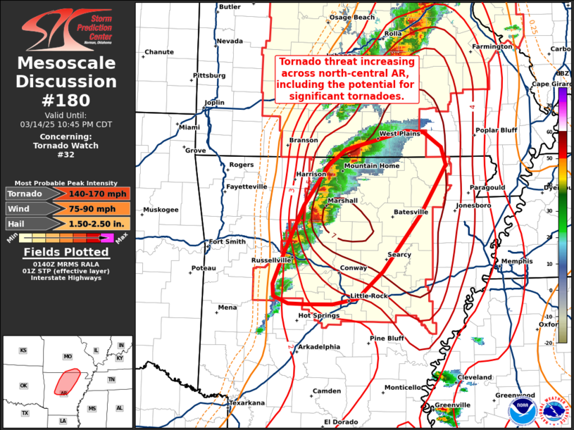
   SUMMARY...Multiple supercells across central/north-central AR will
   pose an increasing tornado threat as they migrate eastward through
   the next couple of hours, including the potential for a significant
   tornado.

   DISCUSSION...Supercells moving out of northwest AR are becoming
   increasingly organized with several well-defined mid-level
   mesocyclones evident in KLZK and KSGF velocity imagery. These storms
   are moving into an environment characterized by STP values on the
   order of 3-5, which is largely being driven by a corridor of warm
   air advection between 925-850 mb over north-central AR. This diffuse
   warm frontal zone is supporting veering winds through the lowest 2
   km with a 0-1 km SRH value of 300 m2/s2 sampled by the 00z LZK
   sounding and around 450 m2/s2 recently sampled by the KLZK VWP. This
   environment is typically supportive of robust, long-lived supercells
   with an attendant threat for tornadoes, including significant
   (EF-2+) tornadoes. The aforementioned convective trends suggest that
   cells are beginning to realize this environment and that the
   downstream tornado threat is likely increasing across central to
   north-central AR.

   ..Moore.. 03/15/2025

   ...Please see www.spc.noaa.gov for graphic product...

   ATTN...WFO...PAH...LZK...SGF...

   LAT...LON   34949341 35369323 35919296 36399258 36599234 36819141
               36799115 36629090 36399083 36139100 35809120 35109178
               34769215 34699252 34699289 34719318 34799340 34949341
|
|
Top/All Mesoscale Discussions/Forecast Products/Home
|
|


