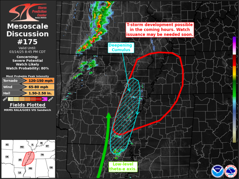
   Mesoscale Discussion 0175
   NWS Storm Prediction Center Norman OK
   0650 PM CDT Fri Mar 14 2025

   Areas affected...Eastern Arkansas into northwest
   Mississippi...western Tennessee...and the Missouri Bootheel

   Concerning...Severe potential...Watch likely

   Valid 142350Z - 150145Z

   Probability of Watch Issuance...80 percent

   SUMMARY...Thunderstorm development appears possible in the next 1-2
   hours across eastern Arkansas. Storms are expected to intensify as
   they migrate east/northeast into adjacent portions of Mississippi,
   Missouri, and Tennessee. Watch issuance is likely as the severe
   threat becomes apparent (though timing is slightly uncertain).

   DISCUSSION...Recent GOES visible and low-level water-vapor imagery
   show a band of gradually deepening cumulus across eastern AR on the
   eastern fringe of a low-level theta-e axis where isentropic ascent
   is regionally greatest. A few orphan anvils and occasional lightning
   flashes have been noted within the last 10-30 minutes, suggesting
   that this may be the early stages of convective initiation that has
   been consistently depicted in recent HRRR solutions over the past
   few hours. However, thunderstorms further south across eastern LA
   that developed in a similar, if not a better from a thermodynamic
   perspective, convective environment have struggled to maintain
   intensity and organization over the past hour. Consequently, it
   remains somewhat uncertain whether robust convective initiation is
   imminent and how widespread storm coverage will be in the next few
   hours. Closer proximity to the primary upper trough may support
   stronger forcing for ascent and perhaps higher probability for
   successful convective initiation. If storms can develop and
   intensify, they will likely pose a threat for all convective
   hazards, including the potential for a strong tornado, given
   favorable buoyancy, deep-layer shear, and low-level SRH observed
   from KLZK and KNQA VWPs (the environment is also characterized by
   SCP values between 12-16 and STP values of 2-4, suggesting a robust
   convective environment). Convective trends will continue to be
   monitored, and watch issuance is likely if/when a severe threat
   begins to materialize.

   ..Moore/Mosier.. 03/14/2025

   ...Please see www.spc.noaa.gov for graphic product...

   ATTN...WFO...PAH...MEG...JAN...LZK...

   LAT...LON   33509186 33669196 34169183 34959151 36369085 36589025
               36638981 36618915 36438878 35928864 35348868 34748897
               34378929 33988977 33549121 33429155 33449171 33509186
|


 @NWSSPC