|
| Mesoscale Discussion 152 |
|
< Previous MD Next MD >
|
|
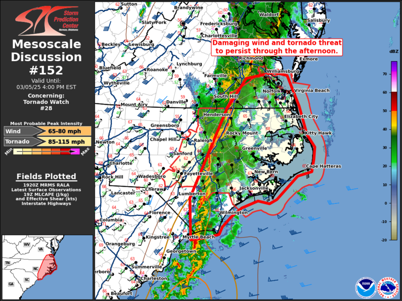
   Mesoscale Discussion 0152
   NWS Storm Prediction Center Norman OK
   0123 PM CST Wed Mar 05 2025

   Areas affected...eastern North Carolina and southeast Virginia

   Concerning...Tornado Watch 28...

   Valid 051923Z - 052100Z

   The severe weather threat for Tornado Watch 28 continues.

   SUMMARY...A damaging wind and tornado threat will persist through
   the afternoon across eastern North Carolina and southeast Virginia.

   DISCUSSION...Low 60s dewpoints have now advected northward ahead of
   the line across eastern North Carolina to near the Virginia border.
   This has resulted in weak surface based instability ahead of the
   squall line. As a result, convection has intensified (evidenced by
   increasing lightning activity) along the line early this afternoon.
   Expect additional strengthening of this line as the downstream
   environment continues to destabilize. Expect widespread damaging
   wind gusts and perhaps a few embedded tornadoes through the
   afternoon and into the early evening. Some discrete convection tried
   to form across eastern South Carolina and southeast North Carolina
   where mid 60s dewpoints are present. However, in the uncapped
   environment, cell interactions quickly resulted in a messy mode
   which has now congealed into part of the greater squall line. Given
   this trend over the past hour, do not anticipate any pre-squall line
   supercells. However, given the strength of the shear, a few embedded
   supercells could be possible through the afternoon and evening,
   particularly across southern North Carolina where greater
   instability is present.

   ..Bentley/Mosier.. 03/05/2025

   ...Please see www.spc.noaa.gov for graphic product...

   ATTN...WFO...AKQ...MHX...RAH...ILM...

   LAT...LON   33707864 34597869 36537774 37187723 37317648 37257612
               36587581 35967561 35697542 35447544 35177551 35077587
               34577643 34497662 34557691 34407734 34207761 33997784
               33837791 33757821 33707864
|
|
Top/All Mesoscale Discussions/Forecast Products/Home
|
|


 @NWSSPC