|
| Mesoscale Discussion 151 |
|
< Previous MD Next MD >
|
|
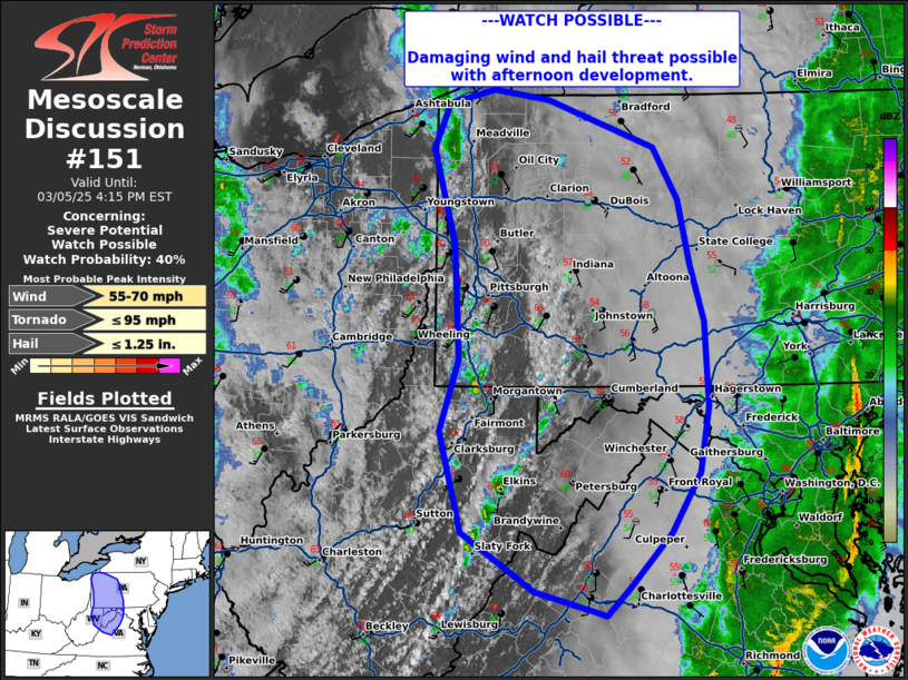
   Mesoscale Discussion 0151
   NWS Storm Prediction Center Norman OK
   0119 PM CST Wed Mar 05 2025

   Areas affected...Northeastern West Virginia...northern
   Virginia...western Pennsylvania

   Concerning...Severe potential...Watch possible

   Valid 051919Z - 052115Z

   Probability of Watch Issuance...40 percent

   SUMMARY...Damaging wind and hail threat may increase with
   thunderstorm development this afternoon.

   DISCUSSION...Diurnal heating along a secondary cold frontal boundary
   located across West Virginia into western Pennsylvania has allowed
   for convective development over the last 30-60 minutes. Temperatures
   have warmed into the 60s ahead of this boundary, yielding around 500
   J/kg of SBCAPE to develop. Looking at the mid-levels, a 500 mb
   90-100 kt jet continues to move northward across the area,
   supporting 0-6 km shear around 90-100 kts. CAM guidance suggests
   further development is possible along the boundary through the
   afternoon. Given strong shear profiles, some loosely organized cells
   may pose a risk for damaging wind and hail. Convective trends will
   be monitored over the next couple of hours for potential watch
   issuance.

   ..Thornton/Mosier.. 03/05/2025

   ...Please see www.spc.noaa.gov for graphic product...

   ATTN...WFO...BUF...CTP...LWX...RNK...PBZ...RLX...CLE...

   LAT...LON   39938027 40838032 41578055 41928038 42037992 41967936
               41587829 41187804 40667792 40227778 39567774 39047784
               38577812 38147854 37937878 38127951 38578025 39368046
               39938027
|
|
Top/All Mesoscale Discussions/Forecast Products/Home
|
|


 @NWSSPC