|
| Mesoscale Discussion 146 |
|
< Previous MD Next MD >
|

|
   Mesoscale Discussion 0146
   NWS Storm Prediction Center Norman OK
   0622 AM CST Wed Mar 05 2025

   Areas affected...much of central South and North Carolina

   Concerning...Severe potential...Watch likely

   Valid 051222Z - 051445Z

   Probability of Watch Issuance...80 percent

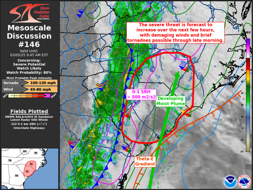
   SUMMARY...The environment is beginning to rapidly change, and a ramp
   up in severe storm potential is likely. Damaging winds and brief
   tornadoes may develop through midday.

   DISCUSSION...A strongly forced line of convection continues to push
   east across the western Carolinas and southeast GA this morning,
   with strong gusts on the order of 40 kt common with this wind shift.
   Although bulk CAPE values are currently low, this will likely change
   over the next few hours, as low-level moisture streams in from the
   south. Local radar indeed shows showers now evident in a north-south
   streamer off the ocean.

   As the front interacts with the moistening air mass, conditions will
   continually become more favorable for rotation within the line, with
   brief tornadoes and damaging winds expected.  Shear is extremely
   strong with 0-1 SRH over 500 m2/s2 over the entire region.

   Further, as pockets of heating develop, additional more discrete
   supercells may develop, most likely during the afternoon and perhaps
   to the east of this early day regime.

   ..Jewell/Smith.. 03/05/2025

   ...Please see www.spc.noaa.gov for graphic product...

   ATTN...WFO...RAH...ILM...CHS...CAE...GSP...

   LAT...LON   32927939 32628000 32578028 32578076 32648110 32868143
               33028151 33388149 34528122 34998106 35258089 35708042
               35927965 35917891 35767846 35297828 33917836 33837847
               33757865 33437903 33137912 32927939
|
|
Top/All Mesoscale Discussions/Forecast Products/Home
|
|


