|
| Mesoscale Discussion 143 |
|
< Previous MD Next MD >
|
|
Mesoscale Discussion 0143
NWS Storm Prediction Center Norman OK
1117 PM CST Tue Mar 04 2025
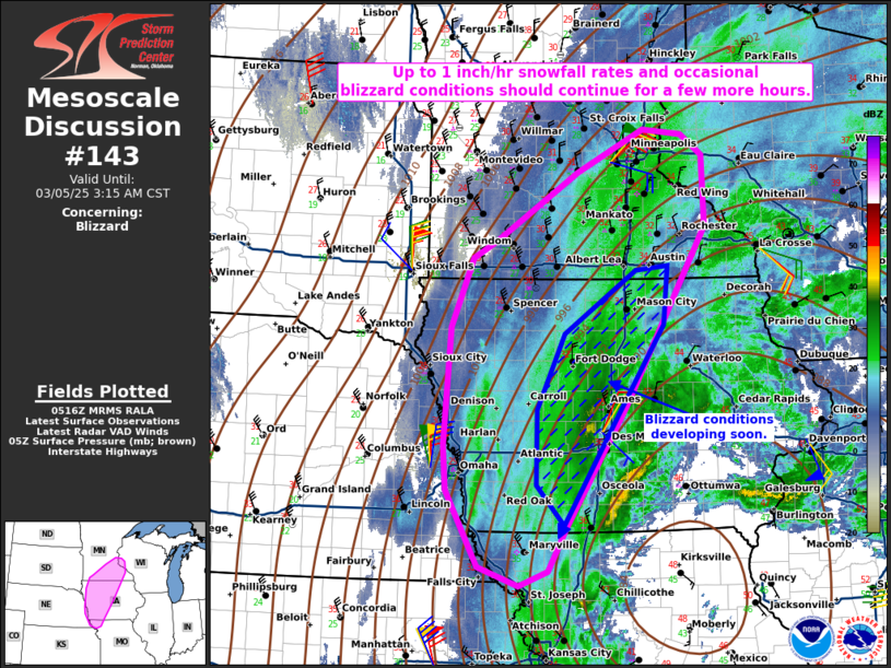
Areas affected...portions of western and central Iowa into southern
Minnesota
Concerning...Blizzard
Valid 050517Z - 050915Z
SUMMARY...Heavy snow should occur for at least a few more hours.
Occasional blizzard conditions remain possible.
DISCUSSION...A surface low over northern MO continues to deepen
while tracking toward the Great Lakes. Across the northwest quadrant
of the surface low, surface observations from western IA into
southern MN have shown north-northwesterly surface winds exceeding
35 kts amid heavy snow and visibility reduced to at least a half
mile in spots. These conditions should continue across the
northwestern quadrant of the surface low for at least a few more
hours, as also suggested by the latest high-resolution model
guidance.
..Squitieri.. 03/05/2025
...Please see www.spc.noaa.gov for graphic product...
ATTN...WFO...ARX...MPX...DMX...EAX...FSD...OAX...
LAT...LON 44109207 42059332 40649425 40119454 39959500 40169562
41069612 41569616 42939607 43749573 43949535 44739408
45219303 45169243 44919209 44109207
|
|
Top/All Mesoscale Discussions/Forecast Products/Home
|
|


 @NWSSPC