|
| Mesoscale Discussion 142 |
|
< Previous MD Next MD >
|
|
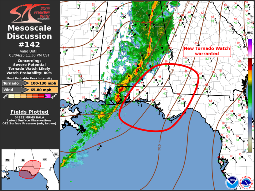
   Mesoscale Discussion 0142
   NWS Storm Prediction Center Norman OK
   1028 PM CST Tue Mar 04 2025

   Areas affected...Florida Panhandle...Southeast Alabama...Southwest
   Georgia

   Concerning...Severe potential...Tornado Watch likely

   Valid 050428Z - 050530Z

   Probability of Watch Issuance...80 percent

   SUMMARY...New Tornado Watch appears warranted.

   DISCUSSION...Mid 60s surface dew points have nosed inland ahead of
   the squall line across the western Florida Panhandle. This air mass
   is providing a bit more buoyancy along southern portions of the MCS,
   which may enhance updraft strength and potential severe. Forecast
   soundings suggest near-surface based convection with 65 dew point,
   but lifted parcels are still likely a bit elevated. Latest buoy data
   suggests 67 dew point is just offshore and this may advance inland
   ahead of the line. Given the very strong shear, there is increasing
   concern for damaging winds, and perhaps a few tornadoes. New Tornado
   watch will likely be issued soon.

   ..Darrow/Guyer.. 03/05/2025

   ...Please see www.spc.noaa.gov for graphic product...

   ATTN...WFO...TAE...BMX...MOB...

   LAT...LON   29758745 31828581 31428368 29258512 29758745
|
|
Top/All Mesoscale Discussions/Forecast Products/Home
|
|


 @NWSSPC