|
| Mesoscale Discussion 105 |
|
< Previous MD Next MD >
|
|
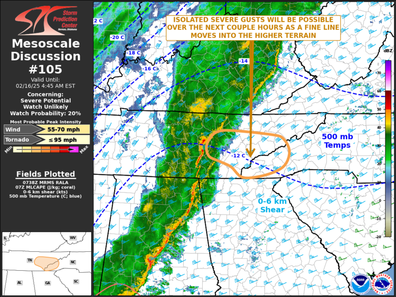
   Mesoscale Discussion 0105
   NWS Storm Prediction Center Norman OK
   0140 AM CST Sun Feb 16 2025

   Areas affected...Eastern Tennessee...Far Western North Carolina

   Concerning...Severe potential...Watch unlikely

   Valid 160740Z - 160945Z

   Probability of Watch Issuance...20 percent

   SUMMARY...Isolated severe gusts will be possible over parts of
   eastern Tennessee and far western North Carolina over the next
   couple of hours. New weather watch issuance appears unlikely.

   DISCUSSION...According to mosaic radar imagery, the northern end of
   a squall line is currently moving through middle Tennessee. Very
   little instability is analyzed ahead of the line. However, the
   latest WSR-88D VWP at Morristown has 0-6 km shear near 75 knots with
   30 to 40 knots of flow in the lowest 1 km. As the squall line moves
   eastward into the higher terrain over the next hour or two, isolated
   damaging gusts will be possible along the leading edge of the line.
   Although a severe threat will likely persist, the threat is expected
   to remain too localized for weather watch issuance.

   ..Broyles/Gleason.. 02/16/2025

   ...Please see www.spc.noaa.gov for graphic product...

   ATTN...WFO...GSP...MRX...OHX...

   LAT...LON   36088332 35978299 35688282 35378293 35178321 35048374
               35028428 35288462 35428498 35538530 35778538 36008526
               36158505 36188463 36088332
|
|
Top/All Mesoscale Discussions/Forecast Products/Home
|
|


 @NWSSPC