|
| Mesoscale Discussion 39 |
|
< Previous MD Next MD >
|
|
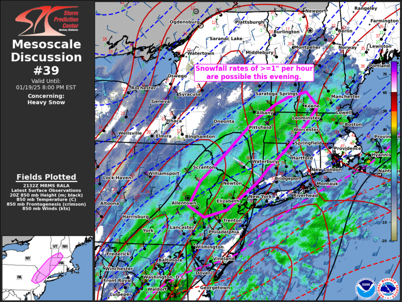
   Mesoscale Discussion 0039
   NWS Storm Prediction Center Norman OK
   0334 PM CST Sun Jan 19 2025

   Areas affected...Portions of the Mid-Atlantic and Northeast

   Concerning...Heavy snow

   Valid 192134Z - 200100Z

   SUMMARY...Heavy snowfall will continue to shift northeastward this
   evening across portions of the Mid-Atlantic and Northeast with rates
   of >=1" per hour possible.

   DISCUSSION...The latest water vapor imagery indicates that the
   mid/upper-level speed max is exiting the coast.  As a result, the
   surface low is deepening off of Delmarva and is forecast to continue
   strengthening offshore and move quickly to the northeast.  Low-level
   frontogenesis will continue to support upward vertical motion and
   precipitation banding.  Precipitation type is more uncertain near
   the coast where strong low-level warm air advection will act to
   offset cooling by evaporation and melting over the next few hours.
   Thus, the corridor with the highest confidence of 1"+ snowfall rates
   over the next few hours has been highlighted.

   ..Jirak/Mosier.. 01/19/2025

   ...Please see www.spc.noaa.gov for graphic product...

   ATTN...WFO...GYX...BOX...OKX...ALY...PHI...BGM...

   LAT...LON   41857286 41487335 41127372 40807419 40527458 40357527
               40617574 41167540 41777467 42177422 42537378 42897315
               43077272 43187218 42867184 42477217 42307238 41857286
|
|
Top/All Mesoscale Discussions/Forecast Products/Home
|
|


 @NWSSPC