|
| Mesoscale Discussion 38 |
|
< Previous MD Next MD >
|
|
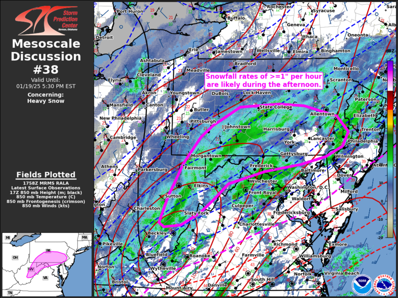
   Mesoscale Discussion 0038
   NWS Storm Prediction Center Norman OK
   1200 PM CST Sun Jan 19 2025

   Areas affected...Portions of Mid-Atlantic States

   Concerning...Heavy snow

   Valid 191800Z - 192230Z

   SUMMARY...Snowfall will continue to increase from southwest to
   northeast across portions of West Virginia, Maryland, and
   Pennsylvania this afternoon with rates exceeding 1" per hour.

   DISCUSSION...An upper-level trough and associated speed max rotating
   around a low near Hudson Bay are moving toward the East Coast this
   afternoon.  In response at the surface, a low over North Carolina is
   forecast to deepen and shift northeastward through the afternoon.
   To the north to northwest of the surface low, low-level
   frontogenesis will promote upward vertical motion and precipitation
   banding.  Given these favorable factors and cold vertical profiles,
   snowfall rates of >=1" per hour are likely this afternoon with
   higher rates possible in banded structures.

   ..Jirak/Mosier.. 01/19/2025

   ...Please see www.spc.noaa.gov for graphic product...

   ATTN...WFO...PHI...CTP...LWX...RNK...PBZ...RLX...

   LAT...LON   39687582 39517657 39347767 39067877 38717917 38377961
               38078019 38018068 38168091 38788077 39448031 40117977
               40437925 40867841 40947721 40887643 40637544 40257509
               39927529 39687582
|
|
Top/All Mesoscale Discussions/Forecast Products/Home
|
|


 @NWSSPC