|
| Mesoscale Discussion 15 |
|
< Previous MD Next MD >
|
|
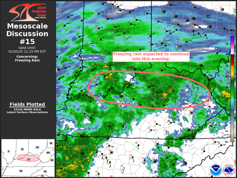
   Mesoscale Discussion 0015
   NWS Storm Prediction Center Norman OK
   0512 PM CST Sun Jan 05 2025

   Areas affected...Portions of southern Indiana and northern Kentucky

   Concerning...Freezing rain

   Valid 052312Z - 060415Z

   SUMMARY...Additional freezing rain, moderate to heavy at times, is
   possible through about midnight to 1 AM EST.

   DISCUSSION...Freezing rain continues to be observed in portions of
   southern Indiana and northern Kentucky. Continued ascent from
   low-level warm advection and the approach of the upstream trough
   will promote continued precipitation into this evening. Regional
   radar shows some heavier pockets of precipitation moving eastward
   from western Kentucky/southern Indiana. Dual-pol radar and surface
   observations indicate that a transition to snow is roughly along the
   Ohio River and should remain in that general vicinity. By midnight
   to 1 AM EST, weakening ascent and drier air moving in aloft will
   likely begin to limit overall precipitation rates and potential for
   ice accumulations.

   ..Wendt.. 01/05/2025

   ...Please see www.spc.noaa.gov for graphic product...

   ATTN...WFO...RLX...JKL...ILN...LMK...IND...PAH...

   LAT...LON   38158726 38648664 38558409 38218279 37848256 37628298
               37548379 37548469 37768671 37938710 38158726
|
|
Top/All Mesoscale Discussions/Forecast Products/Home
|
|


 @NWSSPC