|
| Mesoscale Discussion 14 |
|
< Previous MD Next MD >
|
|
Mesoscale Discussion 0014
NWS Storm Prediction Center Norman OK
0319 PM CST Sun Jan 05 2025
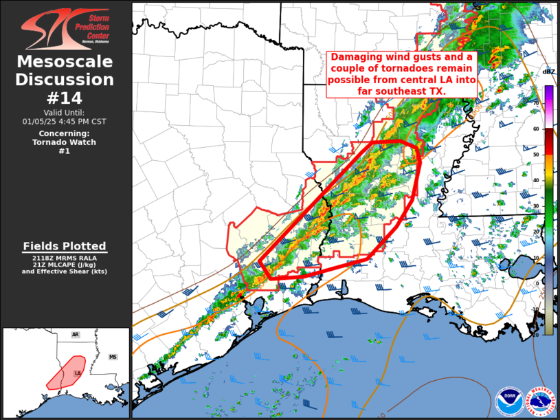
Areas affected...central Louisiana into far southeast Texas
Concerning...Tornado Watch 1...
Valid 052119Z - 052245Z
The severe weather threat for Tornado Watch 1 continues.
SUMMARY...Strong to severe thunderstorms will continue to pose a
risk for damaging wind gusts and a couple tornadoes from central
Louisiana into far southeast Texas the remainder of the afternoon.
DISCUSSION...A QLCS just ahead of an eastward-advancing cold front
will continue to pose a risk for isolated damaging gusts and a
couple of tornadoes, especially across central Louisiana, over the
next few hours. Additional more semi-discrete cells have developed
across the modestly unstable warm sector ahead of the QLCS. This
activity is occurring in a strongly sheared environment, supporting
organized convection with intermittent rotation. However, stronger
surface pressure falls and large-scale ascent will continue to shift
northeast of this area. This may ultimately result in a somewhat
suppressed severe risk compared to areas to the northeast across
northeast LA into western MS.
..Leitman.. 01/05/2025
...Please see www.spc.noaa.gov for graphic product...
ATTN...WFO...JAN...LCH...SHV...HGX...
LAT...LON 31989299 32149279 32159229 32059201 31839194 31269210
30859237 30369289 30109400 30069458 30329477 31989299
|
|
Top/All Mesoscale Discussions/Forecast Products/Home
|
|


 @NWSSPC